



Super El Nino Weakens Over Odisha, Stays Strong Over India: How IMD’s Monsoon Forecast Flipped in State| Exclusive
Key Points
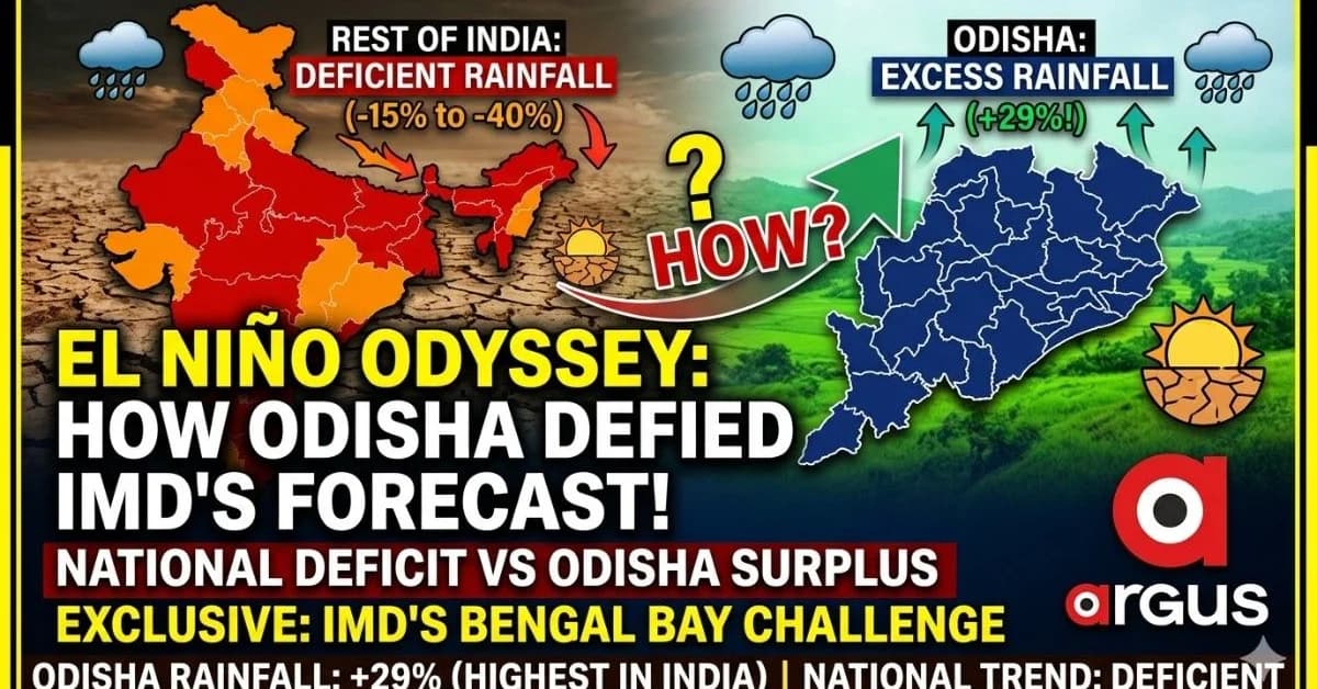
Bhubaneswar: The super El Nino seems to have whimpered in Odisha. Even as its impact is becoming increasingly visible across the country, with state after state recording deficient or less-than-normal rainfall, Odisha has emerged as the biggest outlier – recording a staggering 29% excess rainfall from June 1 to August 18, the highest surplus among all states so far this monsoon.
The contrast is striking. Bihar is staring at a 40% rainfall deficit, Andhra Pradesh 38%, Punjab 36%, Kerala 23%, Karnataka 22%, Rajasthan 16%, Jharkhand 15% and Uttar Pradesh 17%. Madhya Pradesh is 11% deficient, Chhattisgarh 6% deficient and Maharashtra 5% deficient.
Against this backdrop, Odisha's +29% rainfall departure is not merely an exception; it represents a dramatic local reversal of the broader El Nino signal.
Odisha Defies Super El Nino

📱 Get Argus News App
✨The comparative rainfall picture makes Odisha's divergence from the national trend even more pronounced.
|
State |
Rainfall departure, June 1-August 18 |
|
Odisha |
+29% |
|
West Bengal |
+6%
Delhi
+12%
Uttarakhand
0%
Chhattisgarh
-6%
Maharashtra
-5%
Gujarat
-1%
Himachal Pradesh
-4%
Madhya Pradesh
-11%
Haryana
-14%
Jharkhand
-15%
Rajasthan
-16%
Uttar Pradesh
-17%
Karnataka
-22%
Kerala
-23%
Punjab
-36%
Andhra Pradesh
-38%
Bihar
-40%
In other words, Odisha is the only state in this comparison with a surplus as high as 29%. West Bengal, at +6%, and Delhi, at +12%, are the other states on the positive side, but neither comes remotely close to Odisha's surplus. Even, Assam has also recorded around 24% deficit from June 1 to Aug18.
This is precisely where the El Nino paradox emerges. The Pacific warming episode may have exerted a suppressing influence on the Indian monsoon at the macro level, but over Odisha, the Bay of Bengal appears to have repeatedly supplied the moisture and weather systems needed to overpower that larger signal.
A succession of low-pressure systems and depressions over the Bay of Bengal, followed by tracks across north and central Odisha, has effectively created a local atmospheric regime that is behaving very differently from the broader national monsoon pattern.
IMD Rain Forecast Flipped Up In Odisha
This is where the story becomes particularly significant.
IMD's long-range probabilistic outlook had carried a below-normal rainfall signal over large parts of the country, with probabilities rather than a certainty of deficient rainfall. The forecast was based on the larger-scale atmospheric and oceanic signals, including the influence of El Nino.
And for much
of India, that broad signal has begun to materialise.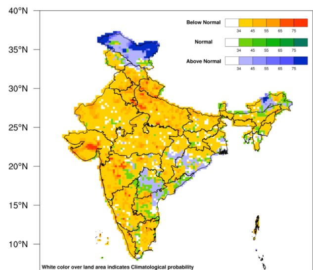
The rainfall numbers from Bihar, Andhra Pradesh, Karnataka, Kerala, Punjab and several central and northern states show how the El Nino-linked suppression has translated into substantial deficits.
But Odisha has moved in the opposite direction.
The IMD forecast map itself needs to be read as a probability forecast, not a deterministic prediction. A 55% or 65% probability of below-normal rainfall does not mean that rainfall must turn deficient. It means there remains a significant probability of the opposite outcome.
That statistical window is precisely where Odisha has escaped.
As the monsoon season progressed, repeated Bay of Bengal low-pressure systems became the game changer.
Instead of allowing the larger El Nino signal to dominate, these systems repeatedly transported moisture towards Odisha and generated heavy rainfall across large parts of the state.
The result: the IMD's broad-scale rainfall signal has held across much of India, but Odisha has emerged as a major forecast outlier.
The state's +29% cumulative surplus is therefore less a rejection of the science behind the long-range forecast and more a demonstration of the limits of a large-scale probabilistic forecast when intense regional weather systems repeatedly alter the rainfall distribution.
District-Wise Rainfall: Odisha's Surplus Is Broad-Based
The most striking aspect is that Odisha's excess rainfall is not confined to one or two pockets.
Of the state's 30 districts, only a handful are in deficit.
Kalahandi (-21%), Nabarangpur (-32%), Malkangiri (-20%), Ganjam (-8%), Rayagada (-15%) and Koraput (-18%) are the principal deficit pockets.
The rest of the state has largely remained on the positive side.
Some districts have recorded exceptionally high cumulative surpluses:
- Boudh: +74%
- Balasore: +67%
- Kendrapara: +64%
- Keonjhar: +62%
- Puri: +45%
- Cuttack: +52%
- Angul: +44%
- Deogarh: +49%
- Sambalpur: +40%
- Sundargarh: +30%
Four districts – Boudh, Balasore, Kendrapara and Keonjhar – have already crossed the +60% mark, placing them in IMD's Large Excess rainfall category.
The geographical spread is important. The surplus stretches from the coastal belt into central and northern Odisha, suggesting that the rainfall anomaly cannot be explained merely by isolated coastal showers.
The weather systems have repeatedly moved inland, dumping substantial rainfall along their tracks.
For Odisha, therefore, the El Nino story has been modified by a much more immediate weather driver: the frequency, strength and trajectory of Bay of Bengal low-pressure systems.
IMD's Odisha Exception
The 2026 monsoon is exposing an important distinction between climate-scale signals and weather-scale events.
El Nino operates at a much larger spatial and temporal scale. It can alter the Walker circulation and influence the overall monsoon environment. But an individual low-pressure system forming over the Bay of Bengal can, within days, redistribute enormous quantities of moisture over a relatively small geographical region.
Odisha has repeatedly been on the receiving end of those systems.
That has created what can effectively be described as an atmospheric decoupling – the national rainfall signal is weak, but Odisha's local monsoon machinery remains highly active.
The result is a state recording the country's highest rainfall surplus at a time when El Nino should theoretically have been a major adverse factor.
How 2026 Differs From 2019 And 2022 El Nino Years
The closest comparisons are 2019 and 2022, two years when Odisha also witnessed powerful low-pressure systems during the August monsoon phase.
But the cumulative rainfall story is markedly different this year.
2019: Heavy August Rain Could Only Erase The Deficit
By August 18, 2019, Odisha's cumulative rainfall departure was around 0% – effectively normal.
The state had experienced a slow start during June and July. A series of low-pressure systems in the first half of August brought a dramatic recovery.
But those systems were essentially repairing the earlier deficit.
By August 18, 23 districts were in the normal category and seven remained deficient, while no district had crossed the +60% Large Excess threshold.
The 2019 August deluge therefore acted as a recovery mechanism rather than creating a massive cumulative surplus.
2022: A Powerful August Flood Pulse
2022 provides a closer physical comparison.
Around August 14-19, a deep depression moved across north-central Odisha, producing intense rainfall and flooding in several districts.
By around August 18, Odisha's cumulative rainfall surplus was in the broad +10% to +14% range.
Individual districts such as Boudh, Sambalpur and Sonepur experienced extraordinary short-term rainfall spikes, but the cumulative June-to-August rainfall picture remained substantially below what Odisha is witnessing in 2026.
2026: Heavy Rainfall On An Already Wet Base
This is the crucial difference.
In 2019, August rainfall had to compensate for a weak start.
In 2022, the August systems generated a major flood pulse.
But in 2026, the repeated heavy-rainfall events are falling on an already well-hydrated monsoon base.
That is why the cumulative number has climbed to +29%.
The current season is therefore not simply an August deluge. It is the compounding effect of successive rainfall events through the monsoon season, amplified by repeated Bay of Bengal systems.
That makes the 2026 Odisha rainfall anomaly structurally different from both 2019 and 2022.
Bottomline
The 2026 monsoon has produced a remarkable El Nino paradox for Odisha.
The El Nino signal is visible across India, but its rainfall suppression has been largely neutralised over Odisha.
With +29% rainfall from June 1 to August 18, Odisha has emerged as India's biggest rainfall-surplus state in the current comparison. At the same time, Bihar is at -40%, Andhra Pradesh at -38%, Punjab at -36% and Karnataka at -22%.
Inside Odisha, only six districts remain in deficit, while Boudh, Balasore, Kendrapara and Keonjhar have crossed +60% excess.
The bigger lesson is that an El Nino year does not automatically translate into a uniform drought-like monsoon across every region. Large-scale climate signals can be overwhelmed locally when the Bay of Bengal repeatedly produces favourable low-pressure systems.
For Odisha
in 2026, El Nino may be strong over India – but over the state, it has so
far been reduced to a whimper.
Also Read: 28% Excess Rainfall in Odisha This Monsoon May Cut Rice Production by 4 LMT | Exclusive