Rare WMO Warning: Will India, Odisha's July Rain Spell End Early? Strong El Niño May Overpower Even Positive IOD, Putting State's Monsoon at Risk| Exclusive
Key Points
Bhubaneswar: A major global climate warning issued by the World Meteorological Organization (WMO) on Friday has raised fresh concerns over the fate of India's monsoon after the ongoing wet spell.
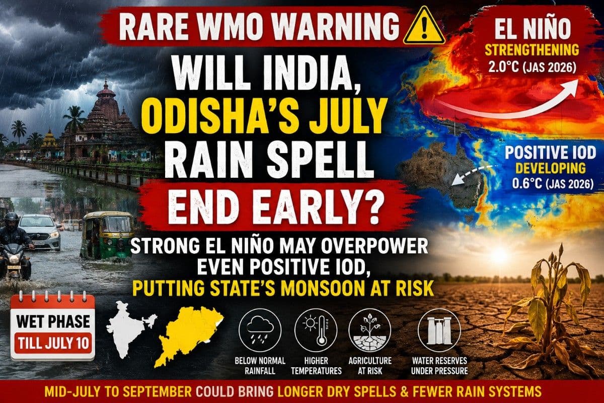
The WMO has confirmed that the Pacific Ocean has already transitioned from ENSO-neutral to weak El Niño conditions during March-May 2026, with the Niño 3.4 index climbing rapidly from 0.0°C in March to 0.9°C in May, averaging 0.5°C for the season. More importantly, the agency projects the El Niño to intensify dramatically to around 2.0°C during July-August-September (JAS) 2026 – an exceptionally steep warming trajectory capable of reshaping global weather patterns.
Adding complexity to the forecast, the WMO has also announced that the Positive Indian Ocean Dipole (IOD) is expected to develop during July-September 2026, with a projected seasonal mean of 0.6°C. Normally, a positive IOD begins emerging in June-July, strengthens through August and peaks during September-October, often helping India's southwest monsoon by boosting moisture transport over the Bay of Bengal.
The warning comes at a time when India is witnessing one of its most active monsoon phases.
Heavy rains are currently lashing large parts of the country – from Mumbai and the Konkan coast in the west to Odisha, including Bhubaneswar, in the east – under the influence of multiple low-pressure systems and an active monsoon trough.
The India Meteorological Department (IMD) and several deterministic weather models indicate that this wet phase is likely to continue until around July 10, bringing widespread rainfall across central, eastern and western India. Meteorologists say this favourable pattern is still being aided by the fact that El Niño remains relatively weak at present.
However, the latest WMO outlook suggests that the atmospheric balance could begin changing rapidly after mid-July as El Niño strengthens.
What Could Change From Mid-July?
If the WMO projection materialises, mid-July through September could witness a very different monsoon character across India.
Instead of frequent low-pressure systems and Bay of Bengal depressions bringing regular rainfall, meteorologists expect longer monsoon breaks, fewer organised rain-bearing systems and larger dry spells between rainfall events. While isolated heavy rain events cannot be ruled out, the overall seasonal rainfall distribution is expected to become more erratic.
Across India, the strongest impacts are likely to include:
- Below-normal seasonal rainfall across major agricultural belts.
- Longer dry spells during July and August.
- Above-normal temperatures due to reduced cloud cover.
- Increased heat stress despite the monsoon season.
- Pressure on reservoirs, irrigation and drinking water supplies if rainfall deficits persist.
Odisha: District-Wise Outlook
Coastal and Central Odisha
Ganjam, Puri, Khordha, Cuttack, Jagatsinghpur, Kendrapara, Bhadrak, Balasore and Jajpur
📱 Get Argus News App
✨These districts depend heavily on Bay of Bengal depressions. If El Niño suppresses their formation, rainfall could become less frequent after July.
Likely impacts
- Fewer organised low-pressure systems.
- Rising humid heat despite proximity to the sea.
- Reduced inflows into the Mahanadi and Brahmani river systems.
- Greater stress on reservoirs, urban water supply and electricity demand.
Western Odisha
Bargarh, Bolangir, Sambalpur, Nuapada, Kalahandi, Jharsuguda, Sonepur and Deogarh
This region is expected to face the highest moisture stress.
Likely impacts
- Rapid depletion of soil moisture during the critical paddy transplantation period.
- Increased agricultural drought risk in rain-fed fields.
- Greater dependence on irrigation.
- Possibility of switching to short-duration or less water-intensive crops if rainfall weakens significantly.
Northern and Southern Tribal Belt
Mayurbhanj, Keonjhar, Sundargarh, Koraput, Malkangiri, Rayagada, Nabarangpur and Kandhamal
Although these hilly districts may continue receiving occasional localized thunderstorms due to terrain effects, seasonal rainfall could still remain below normal.
Likely impacts
- Early drying of hill streams and springs.
- Reduced groundwater recharge.
- Drinking water stress emerging earlier than usual after the monsoon.
- Forest moisture declining faster during late monsoon.
Why Even a Positive IOD May Not Save the Monsoon This Time
Ordinarily, a positive Indian Ocean Dipole acts as a natural ally of the Indian monsoon. Warmer waters in the western Indian Ocean strengthen convection and help generate moisture-rich cloud bands and Bay of Bengal depressions, often offsetting some of El Niño's drying influence.
However, the WMO says 2026 is different.
The projected jump in El Niño from 0.5°C to nearly 2.0°C within a single season is expected to generate an exceptionally strong atmospheric response by shifting the Walker Circulation eastward. This creates widespread subsidence – large-scale sinking air over the Indian subcontinent—which suppresses cloud formation and rainfall.
In simple terms, although the Indian Ocean may become favourable through a positive IOD, the much stronger Pacific-driven El Niño could dominate the atmosphere above India, preventing that extra oceanic warmth from translating into sustained rain-bearing systems.
That is why forecasters believe the positive IOD's traditional monsoon-supporting role may be significantly muted in 2026, making water management, contingency crop planning and continuous monitoring of monsoon evolution especially critical for both India and Odisha during the second half of the rainy season.Also Read: Mumbai's 4th Driest June Since 1947 Ends! 80-150 mm Rainfall Per Day Likely from July 5-8 | Exclusive
Related Topics
Explore more stories