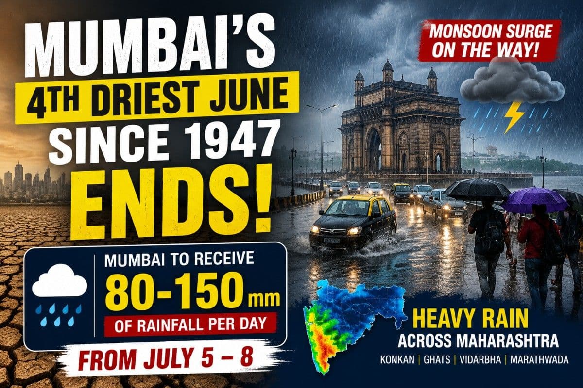
Mumbai's 4th Driest June Since 1947 Ends! 80-150 mm Rainfall Per Day Likely from July 5-8 | Exclusive
Key Points
Bhubaneswar: After enduring one of its weakest monsoon starts in nearly eight decades, Mumbai is now staring at a dramatic weather turnaround.
Suburban Mumbai has ended June with a 63% rainfall deficit, making June 2026 the fourth driest June in the city's recorded post-Independence history. Santacruz, the city's official suburban observatory, received only about 199 mm of rainfall against its long-period average (LPA) of around 505 mm, placing this year's delayed monsoon alongside some of India's most severe drought-linked June seasons.
The historical comparison underlines just how rare this deficit has been.
Since 1947, only three years witnessed a drier June than 2026.
The all-time driest remains 1972, when Santacruz recorded a negligible 0.2 mm, followed by 2014 (87.3 mm) and the El Niño-hit 2009 (145 mm).
With an estimated 199.1 mm this June, 2026 overtakes years like 2012 (298.5 mm) and becomes the driest June in Mumbai since 2014 and the third driest of the 21st century. The figures also mean the city closed June with barely 37% of its normal monthly rainfall, an exceptionally rare occurrence for India's financial capital.
Winds Taking A Turn
However, the weather pattern is now undergoing a decisive reversal, with two of the world's leading forecast systems indicating that the prolonged dry spell is about to give way to a sustained spell of heavy rainfall.
Forecasts from the European Centre for Medium-Range Weather Forecasts (ECMWF) and India's National Centre for Medium Range Weather Forecasting (NCMRWF) show remarkable agreement that a strong monsoon surge will strike Maharashtra during the first week of July, significantly increasing rainfall over Mumbai, the Konkan coast and later across interior Maharashtra.
The Twist in Story
Both forecast models indicate the formation of a powerful low-level southwesterly jet at 850 hPa, with wind speeds reaching 15-25 metres per second over the Arabian Sea before slamming into the Konkan coastline.
At the same time, a well-established monsoon trough stretching across central India is expected to prevent the moisture from rapidly moving inland, forcing prolonged moisture convergence along the windward side of the Western Ghats. This combination represents one of the strongest synoptic setups seen so far this season and considerably raises confidence in a widespread heavy rainfall event.
The Significant Dates
For Mumbai, Thane, Palghar and Raigad, the most intense phase is expected between July 5 and July 8.
While the model outputs display grid-average rainfall bands exceeding 32-64 mm per forecast interval, the strong onshore winds interacting with the Western Ghats are likely to substantially amplify rainfall locally.
📱 Get Argus News App
✨As a result, Mumbai is expected to receive 80-150 mm of rainfall per day during the peak phase, with isolated pockets along the suburbs and eastern slopes of the city potentially recording over 200 mm in 24 hours under persistent rain bands. The event is expected to be characterised more by continuous heavy rainfall over several days rather than short-lived cloudbursts, increasing the risk of waterlogging and transport disruptions.
The Western Ghats of Maharashtra are expected to witness the heaviest rainfall during this spell. Districts including Pune Ghat sections, Satara, Kolhapur and Nashik's windward slopes could receive 150-250 mm daily, while isolated high-elevation locations may cross 300 mm if the moisture plume remains stationary. The forecast also shows the classic rain-shadow effect, with rainfall dropping sharply to around 10-40 mm per day over eastern parts of western Maharashtra immediately beyond the Ghats.
Taking Maharashtra In its Sweep
The monsoon revival is not expected to remain confined to the coast. As the low-pressure circulation over central India gradually deepens and shifts westwards between July 8 and July 10, widespread rainfall is forecast to spread into Vidarbha and Marathwada. Cities including Nagpur, Amravati, Akola, Wardha, Chandrapur, Aurangabad, Latur, Beed and Nanded are likely to receive 30-70 mm of rainfall daily, with isolated thunderstorms producing 80-120 mm in some districts. The expansion of rainfall into these interior agricultural belts is expected to provide a much-needed boost to kharif sowing after an uneven onset of the southwest monsoon.
All is Well?
Ironically, Mumbai's poor June does not necessarily indicate a weak monsoon season. Historical records show that the city's rainfall is heavily concentrated during July and August.
Years such as 1990 and 2023 (El Nino year) demonstrated how subdued June rainfall was completely offset by exceptionally wet mid-monsoon months, with seasonal deficits erased through prolonged heavy spells.
The moot question here is will 2026 may once again follow this familiar pattern of a delayed but vigorous monsoon recovery?
Why June Turns Dry For Mumbai
Meteorologists attribute the unusually dry June to a combination of stalled atmospheric processes.
Although the southwest monsoon reached Kerala close to its normal date, the initial advance weakened along the Konkan coast.
A persistent anticyclonic circulation north of Maharashtra suppressed cloud development and blocked the normal northward advance of moisture-laden westerlies.
The absence of any significant pre-monsoon cyclone over the Arabian Sea or Bay of Bengal also deprived the monsoon of the atmospheric pull that has accelerated onset in recent years.
In addition, evolving El Niño conditions weakened the cross-equatorial flow, delaying the establishment of a robust Arabian Sea monsoon current.
The Bottomline
Those
inhibiting factors are now rapidly breaking down. With the anticyclonic block
weakening and a strong Arabian Sea jet becoming firmly established, forecast
confidence has increased substantially that Maharashtra is entering its first
major monsoon surge of the season. For Mumbai, that could mean the city's
historically dry June is soon replaced by several days of soaking rainfall
capable of significantly narrowing the seasonal rainfall deficit within the
opening weeks of July.
Also Read: From July 6, 16–32 mm Daily Rainfall to Lash Odisha’s Mayurbhanj to Bhubaneswar; Baitarani-Budhabalanga Basin Under Watch| Exclusive
Related Topics
Explore more stories