



Odisha’s Flood-Hit North May Get a Breather as New Low Pressure Area Over Bay Likely Shifts Rain Belt South, West| Exclusive
Key Points
The current rain spell over Odisha has paused with no active weather systems overhead, offering much-needed relief to flood-hit northern coastal districts.
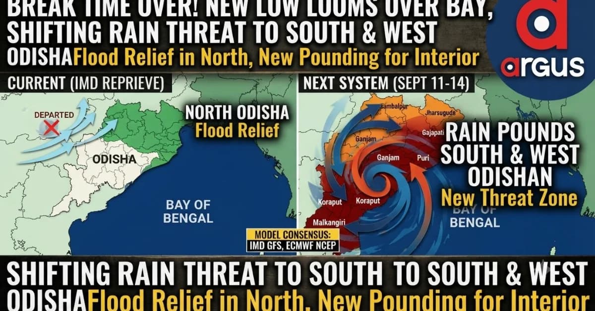
Numerical models like IMD GFS, NCEP GFS, and ECMWF indicate a fresh low-pressure system forming over the Bay of Bengal in the first half of the coming week.
The upcoming weather system is projected to shift the heavy rainfall burden away from the north toward southern and western interior regions.
Bhubaneswar: After a long rain spell over Odisha, it seems the skies are taking a break. No weather system is active over Odisha.
The latest IMD assesment marks the sky's 'break-time'. The Well Marked Low that deteriorated the flood situation over north Odisha has now sitting over north-east Madhya Pradesh on Thursday. Even the Monsoon trough is now not passing over Odisha.
The latest IMD weather analysis says, “The Monsoon trough at mean sea level is now passing through Sriganganagar (Rajasthan), centre of well marked LPA over northeast MP, Jharkhand's Daltonganj and running via Digha (West Bengal) to northeast Bay of Bengal.
However, the early September break-time may not last long enough.

📱 Get Argus News App
✨The India Meteorological Department (IMD) extended-range outlook indicates the development of a fresh system in the first half of the coming week.
While the outlook does not yet pin down a precise landfall location, but a study of IMD GFS model, NCICS, NCEP-GFS and ECMWF suggests big.
The BIG hint: Odisha could see a significant shift in the rainfall threat zone with the upcoming weather system, potentially giving the flood-hit northern coastal districts a crucial window for recovery while moving the heavier rain burden towards southern and western parts of the State
IMD-GFS and other weather models' rainfall anomaly pattern points towards a south-southwestward setup, with the northwest and south interior emerging as the two stronger rainfall zones.
That is significant for Odisha, particularly after the recent flooding in parts of the northern coastal belt. The extended outlook suggests that the next system may not reproduce the same rainfall concentration over the flood-hit northern districts.
GFS Sees Rain Pounding South, Coastal And Northwest Odisha
The NCEP GFS model places a closed 1004-hPa low over the west-central Bay of Bengal, close to the South Odisha coast, on September 11. The associated moisture feed wraps around the system and pushes precipitation into South Odisha, the coastal belt and further towards northwest Odisha.
The GFS rainfall footprint therefore looks substantially different from a system centred farther north in the Bay. Ganjam, Gajapati and Puri emerge among the coastal districts under stronger influence, while the rainfall belt extends inland towards Bargarh and Jharsuguda.
GFS/ECMWF rainfall-risk zones
|
Model |
Expected low position |
Main Odisha rainfall zone |
Key districts indicated |
|---|---|---|---|
|
ECMWF |
Off South Odisha/North Andhra coast on Sept 11; shifts closer to South Odisha by Sept 14 |
South and west-central interior |
Koraput, Malkangiri, Rayagada, Kalahandi, Kandhamal, Nuapada |
|
NCEP GFS |
West-central Bay/South Odisha coast; around 1004 hPa |
South, coastal and northwest Odisha |
Ganjam, Gajapati, Puri; rainfall extends towards Bargarh and Jharsuguda |
|
IMD Extended Outlook |
Fresh system forming in first half of week |
Northwest and south interior |
Twin peak rainfall zones |
The ECMWF similarly shows a 1007-hPa low off South Odisha/North Andhra on September 11, moving closer to South Odisha by September 14. Its precipitation maps keep the stronger rainfall signal across the lower half of the State, with Koraput, Malkangiri, Rayagada, Kalahandi, Kandhamal and Nuapada among the areas of concern.
Why South And Western Odisha Could Take the Pounding
The location of the projected low is the key.
With the circulation developing closer to South Odisha and the adjoining west-central Bay, the system would pull the eastern end of the monsoon trough southward and channel moisture inland along its trajectory. This creates a pathway for heavy rain to penetrate the southern and western interior rather than concentrating over the northern river basins.
The implications are particularly important for the Vansadhara, Rushikulya and Indravati catchments, which could become the primary hydrological risk zones if the projected rainfall materialises. At the same time, the northwest, particularly Sambalpur, Jharsuguda and Sundargarh, could remain vulnerable as the low acts as an anchor for the monsoon trough while moving inland.
District-wise IMD forecast after September 9
|
Alert level |
Expected rainfall |
Districts |
Main risk |
|---|---|---|---|
|
Orange Alert |
Very heavy: 11.5–20.4 cm |
Mayurbhanj, Kendujhar, Sundargarh |
Localised flash floods in hilly catchments, waterlogging, structural damage and poor visibility |
|
Yellow Alert |
Heavy: 6.4–11.5 cm |
Jharsuguda, Sambalpur, Deogarh, Bargarh, Angul, Dhenkanal |
Thunderstorm, lightning, gusty winds and sudden intense rainfall |
|
Green Zone |
Below 6.4 cm |
Balasore, Bhadrak, Jajpur, Kendrapara |
Light to moderate rain; relatively better conditions for flood relief and recovery |
The IMD-based district outlook, however, carries an important distinction: while the flood-hit coastal belt of Balasore, Bhadrak, Jajpur and Kendrapara is placed in the light-to-moderate rainfall category, some northern interior districts – Mayurbhanj, Kendujhar and Sundargarh – remain under an orange-alert signal in that particular forecast.
This means "northern Odisha being spared" should primarily be read in the context of the recently flood-hit northern coastal belt, rather than every district geographically located in northern Odisha.
NCMRWF Is The Outlier – It Keeps Heavy Rain Away From Odisha
The biggest uncertainty comes from the NCMRWF GLB model, which presents a dramatically different scenario for September 11–13.
Unlike GFS and ECMWF, NCMRWF keeps the strongest rainfall bands over the North Bay of Bengal, tracking them northeastwards towards the Bangladesh and Myanmar coasts. Under this model, the major rainfall system largely remains offshore and Odisha escapes the main downpour.
Its district-wise signal is particularly striking:
|
Region / districts |
Sept 11–13 NCMRWF forecast |
Daily accumulated rainfall |
|---|---|---|
|
Northern Coastal Belt — Balasore, Bhadrak, Kendrapara, Jagatsinghpur |
Very light showers on Sept 11; largely dry Sept 12–13 |
0.1–1.0 cm |
|
Northern Interior — Mayurbhanj, Kendujhar, Sundargarh |
Light rain Sept 11–12; dry/clear Sept 13 |
0.1–2.0 cm |
|
Central & Western Interior — Sambalpur, Angul, Jharsuguda, Bargarh |
Negligible rain/clear |
0.0–0.1 cm |
|
Southern & Coastline — Ganjam, Puri, Khordha, Koraput |
Completely dry |
0.0 cm |
The model's rainfall maps show the most intense 8–16 cm rainfall bands remaining offshore rather than moving inland over Odisha.
That makes NCMRWF the clear outlier against the GFS-ECMWF scenario, which instead develops the low closer to South Odisha and drives moisture into the State.
Bottomline: Low Over Bay Looks Increasingly Imminent, But Rainfall May Shift
Going by the IMD extended outlook, a low-pressure formation over the Bay of Bengal appears increasingly imminent. The GFS and ECMWF projections then provide a more specific spatial signal, placing the developing system closer to South Odisha and the adjoining west-central Bay between September 11 and 14.
The emerging consensus of the IMD GFS, NCICS, NCEP GFS and ECMWF therefore points towards a potentially different rainfall zone this time – with the flood-hit northern coastal belt likely to get a relative breather, while South and western Odisha could bear the pounding rain.
The caveat is that the IMD's district-level forecast still keeps some northern interior districts such as Mayurbhanj, Kendujhar and Sundargarh under a heavier-rain signal, while NCMRWF remains distinctly more conservative.
As
all these predictions are based on numerical models, it remains to be
seen who will have the last laugh!
Also Read:No Flood Relief Seems for Odisha: 3 Model Forecasts See Fresh Low Around Sept 9; Check Rain in Your District | Exclusive
Related Topics
Explore more stories