Odisha to Build Six-Radar Weather Shield: Bhubaneswar, Puri & Balasore Join Doppler Network to Deliver Hyper-Local 3-Hour Storm Warnings| Special Report
Key Points
Odisha expands to a dense 6-radar grid, positioning the state as India’s third-largest Doppler network by density.
Tailored deployment matches S-band coastal tracking with C-band inland storm monitoring and urban X-band flash flood nowcasting.
Upgraded dual-polarization technology switches forecasting from broad district warnings to 3-hour neighborhood-level particle analysis.
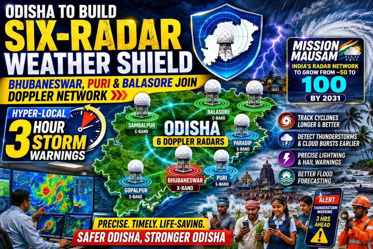
Bhubaneswar: In a major boost to Odisha's
disaster preparedness, the state government has announced that three new Dual-Polarised
Doppler Weather Radars (DWRs) will be installed at Bhubaneswar, Puri and
Balasore, while the long-pending Sambalpur radar is set to be
commissioned this year.
Once all four become operational, Odisha's Doppler
radar network will expand from the existing two radars at Paradip and
Gopalpur to six, creating one of India's densest weather surveillance grids
capable of issuing highly localised warnings for thunderstorms, lightning,
cloudbursts and cyclone-induced heavy rainfall nearly three hours in advance.
The proposed radar configuration has been designed to address Odisha's diverse weather vulnerabilities. Paradip and Gopalpur will continue as long-range S-band coastal radars dedicated primarily to tracking Bay of Bengal cyclones. The new Puri radar will also be an S-band system, strengthening cyclone surveillance along the state's most vulnerable coastline. Bhubaneswar will receive an X-band radar for high-resolution urban weather monitoring, while Balasore and Sambalpur will have C-band radars to monitor severe thunderstorms, intense rainfall and inland weather systems across northern and western Odisha.
Odisha's Big Leap Under Mission Mausam
The expansion is part of the Modi Government's flagship Mission Mausam, an ambitious programme of the Ministry of Earth Sciences aimed at making India "weather-ready and climate-smart." Under the mission, India's Doppler Weather Radar network is being expanded from around 50 operational radars today to nearly 100 by 2031, creating one of the world's largest high-density weather observation systems.
For Odisha, Mission Mausam marks a transformational shift. With six operational Doppler radars by the end of the rollout, the state is projected to emerge as India's third-largest Doppler radar network, behind Maharashtra and Uttar Pradesh in terms of planned radar density.
For one of India's most disaster-prone states – regularly battered by tropical cyclones, Nor'westers (Kalbaishakhi storms), lightning and intense monsoon spells – the expanded network is expected to significantly reduce weather blind spots from the coastline to western districts.
A Statewide Weather Shield: How Each Radar Will Protect Odisha
The six-radar grid has been strategically distributed to ensure almost complete weather surveillance across Odisha.
Paradip (S-band) will continue monitoring cyclones developing over the northern Bay of Bengal, providing long-range tracking of approaching weather systems before landfall.
Gopalpur (S-band) will guard the southern coast, tracking cyclones, deep depressions and heavy rain bands moving towards southern Odisha.
Puri (S-band) will become the frontline radar for cyclone landfalls, allowing meteorologists to monitor rapid structural changes inside storms as they approach the coast. It will also improve lightning and squall warnings for the state's large pilgrim and tourist population.
Bhubaneswar (X-band) will focus on high-resolution urban weather monitoring. Unlike conventional regional forecasts, the X-band radar can detect rapidly developing thunderstorm cells over the capital, helping authorities anticipate intense short-duration rainfall, urban flooding and lightning strikes before they occur.
Balasore (C-band) will strengthen surveillance over northern Odisha, one of the regions frequently affected by violent Nor'westers, hailstorms and intense convective rainfall. Farmers will benefit from more precise warnings before damaging thunderstorms hit standing crops.
📱 Get Argus News App
✨Sambalpur (C-band) will extend radar coverage deep into western Odisha, tracking thunderstorm formation, heavy rainfall over the upper Mahanadi basin and weather systems affecting interior districts that were previously outside the state's dedicated radar network.
Together, the six-radar network will create overlapping coverage across coastal, central and western Odisha, ensuring that severe weather systems are monitored continuously as they evolve and move across districts.
Why Dual-Polarised Doppler Radars Are Different
Unlike conventional Doppler radars, which transmit radio waves in only one direction, dual-polarised Doppler Weather Radars transmit both horizontal and vertical pulses simultaneously. This allows them not only to detect where a storm is and how fast it is moving, but also to determine the shape, size and type of particles inside clouds.
As a result, meteorologists can distinguish between heavy rain, hail, drizzle, melting ice and even debris carried by severe storms. The technology also measures rainfall intensity far more accurately, enabling precise estimation of how much rain will fall over a specific location instead of issuing broad regional forecasts.
When multiple dual-polarised radars operate together as a network, they scan the same storm from different directions, eliminating blind spots caused by terrain or distance. This significantly improves rainfall estimation, thunderstorm tracking and lightning nowcasting, allowing forecasters to identify dangerous weather cells much earlier.
From District Forecasts to Neighbourhood-Level Warnings
The biggest benefit for ordinary citizens will be the shift from broad weather forecasts to hyper-local nowcasting.
Today, weather alerts often cover entire districts. With the expanded Doppler grid, IMD Bhubaneswar will be able to identify where a thunderstorm cell is forming, estimate its rainfall intensity, monitor its movement and issue warnings for specific towns or neighbourhoods several hours before impact.
For Odisha, where Nor'westers can develop rapidly and produce destructive winds, lightning and cloudbursts within minutes, such precision can provide valuable time for schools, fishermen, farmers, municipal authorities, emergency services and the public to take preventive action.
The expanded network will also improve flood forecasting by supplying more accurate rainfall data over river catchments, enabling disaster managers to anticipate flash floods triggered by intense monsoon or cyclone-related rainfall.
Bottom Line
Odisha has spent decades strengthening its cyclone evacuation system and disaster response, earning global recognition for saving lives during major storms. The expansion of its Doppler Weather Radar network marks the next phase of that journey – from responding to disasters to predicting them with much greater precision.
For citizens, this means earlier and more accurate warnings before thunderstorms, lightning, cloudbursts or cyclone-induced heavy rainfall strike. For disaster managers, it means the ability to pinpoint exactly where dangerous weather is developing and deploy resources before the crisis unfolds.
In a state
where weather can change dramatically within hours, Odisha's six-radar grid has
the potential to become one of its most powerful life-saving infrastructures,
transforming weather forecasting from broad regional advisories into precise,
location-specific early warnings.
Also Read: From July 6, 16–32 mm Daily Rainfall to Lash Odisha’s Mayurbhanj to Bhubaneswar; Baitarani-Budhabalanga Basin Under Watch| Exclusive
Related Topics
Explore more stories