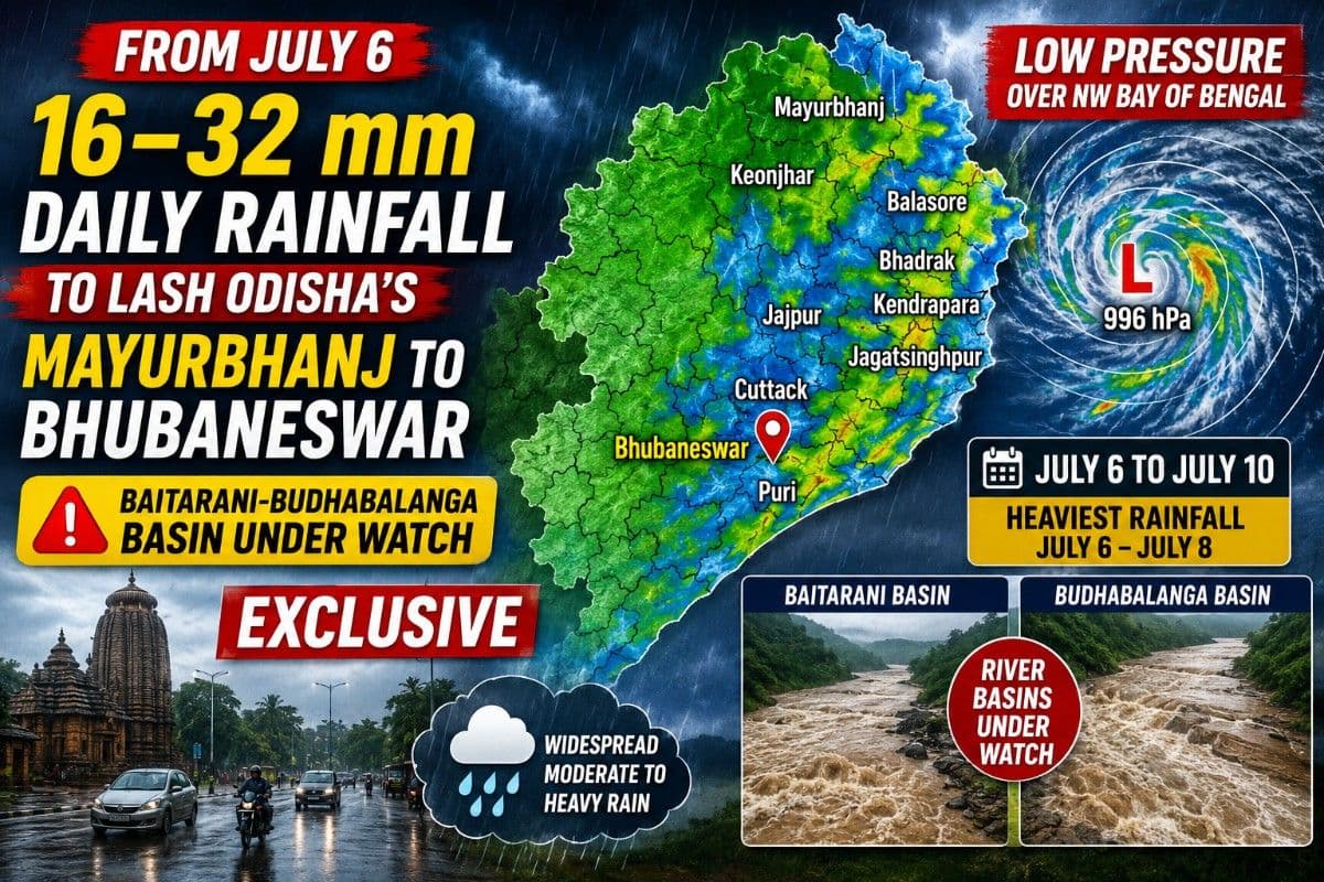
From July 6, 16–32 mm Daily Rainfall to Lash Odisha’s Mayurbhanj to Bhubaneswar; Baitarani-Budhabalanga Basin Under Watch| Exclusive
Key Points
* Mayurbhanj, Balasore, Bhadrak, Bhubaneswar, Cuttack and adjoining districts may receive 16–32 mm of daily rainfall in the first phase.
* Baitarani, Budhabalanga, Brahmani and Mahanadi river basins likely to witness increased runoff as the rain belt shifts westward.
Bhubaneswar: After recording second driest June in 46 years, where the State recorded only 110mm rainfall, July seems singing the oldie goldie “Aya Sawan Jhoom Ke..”
Yes, you are hearing right.
The State is set to enter into a spell of widespread monsoon activity courtesy the formation of a low-pressure area over the northwest Bay of Bengal, which is expected to trigger moderate to heavy rainfall across large parts of the state from July 6 onward, with the heaviest precipitation initially concentrated over the northern coastal and adjoining interior districts before gradually shifting westwards.
An analysis of the latest NCMRWF numerical weather prediction fields alongside ECMWF mean sea level pressure (MSLP) and precipitation charts shows a strong consensus on the evolution of the weather system and its rainfall footprint over Odisha through July 10.
Low Pressure to Form Off Odisha Coast
The ECMWF surface pressure charts indicate that a 996 hPa low-pressure area will take shape over the northwest Bay of Bengal on July 5, just off the Odisha-West Bengal coast.
As the system gradually moves inland between July 6 and July 8, pressure gradients are expected to tighten while low-level southwesterly winds strengthen considerably over Odisha. Simultaneously, falling geopotential heights at the 850 hPa level indicate deepening atmospheric instability, creating favourable conditions for sustained rainfall across much of the state.
Meteorologically, the transition marks a shift from isolated monsoon showers to organized cyclonic rainfall covering both coastal and interior Odisha.
July 6 to Bring First Major Rain Surge
The first phase of the event is expected between July 5 and July 6, when rainfall bands associated with the developing low-pressure system spread inland from the Bay.
Model guidance suggests daily rainfall of around 16-32 mm across several districts, with locally higher totals in areas experiencing persistent convective bands.
The districts likely to witness the strongest impact include:
- Mayurbhanj
- Balasore
- Bhadrak
- Kendrapara
- Jagatsinghpur
- Keonjhar
These districts lie closest to the northern flank of the developing low-pressure system where moisture convergence is expected to be strongest.
The rainfall shield is also expected to extend rapidly towards the central coastal belt, bringing widespread rain over:
- Bhubaneswar (Khurda)
- Cuttack
- Puri
- Jajpur
Residents across these districts may experience prolonged spells of rain rather than short-duration thunderstorms as successive rain bands move inland.
Rain Belt to Shift Towards Western Odisha
As the low-pressure area progresses inland between July 7 and July 8, the axis of heaviest rainfall is projected to migrate towards western and central Odisha.
Model precipitation fields show an expanding corridor of widespread rainfall stretching across:
- Bargarh
- Jharsuguda
- Sambalpur
- Sonepur
- Balangir
- Angul
This westward migration coincides with the inland movement of the low-pressure circulation along the active monsoon trough, allowing moisture to penetrate deep into interior Odisha.
The result is expected to be a prolonged spell of moderate to heavy rainfall over western districts extending into July 9.
Two Weather Systems to Reinforce Odisha Monsoon
The upcoming spell is not being driven by a single weather system alone.
Model analysis indicates that the northwest Bay low-pressure area will interact with an existing low-pressure zone and monsoon trough over Central India, creating what meteorologists describe as a binary reinforcement mechanism.
The elongated monsoon trough stretches from Central India to the northwest Bay of Bengal, placing Odisha directly beneath one of its most active segments.
📱 Get Argus News App
✨This atmospheric configuration continuously channels moisture-laden southwesterly winds from the Bay into the state while simultaneously drawing additional moisture westwards towards Central India.
The result is sustained rainfall over Odisha over several consecutive days instead of a brief heavy rain event.
East and West Odisha to Receive Rain From Different Drivers
The rainfall distribution also reflects the influence of the two systems.
During the initial phase, the Bay low intensifies convergence over northern and coastal Odisha, producing heavier rainfall over districts such as Mayurbhanj, Keonjhar, Balasore and Bhadrak.
As the inland low over Central India strengthens, rainfall gradually becomes concentrated across western Odisha, affecting Bargarh, Jharsuguda, Sambalpur and adjoining districts.
This dual forcing allows rainfall to remain widespread across Odisha even as the primary rain belt shifts inland.
River Basins Under Close Watch
The evolving weather pattern is also expected to significantly influence river inflows across Odisha.
Baitarani and Budhabalanga Basins
These basins are expected to witness the earliest hydrological response between July 5 and July 6.
Since the northern rain bands of the developing low-pressure system are projected to move directly across the Keonjhar-Mayurbhanj highlands, rapid runoff into upstream tributaries of the Baitarani and Budhabalanga rivers is considered likely.
These basins may therefore experience the quickest rise in water levels during the initial phase of the event.
Lower Mahanadi and Brahmani Basins
Heavy rainfall over Angul, Dhenkanal, Jajpur and Cuttack between July 5 and July 7 is expected to increase runoff into the lower Mahanadi delta and Brahmani river system.
While the rainfall is forecast to aid reservoir inflows and improve water availability, localized drainage congestion and temporary waterlogging cannot be ruled out in low-lying areas receiving persistent rain.
Upper Mahanadi Basin
The focus then shifts towards the Hirakud catchment between July 7 and July 9.
With widespread rainfall projected over Bargarh, Jharsuguda and Sambalpur, the upper Mahanadi basin is expected to receive sustained inflows, contributing to reservoir replenishment across western Odisha.
Multi-Basin Rainfall Event Likely
One of the notable features of this weather episode is that Odisha's major river systems are expected to receive rainfall almost simultaneously.
The upper Mahanadi catchment is forecast to receive rain from the Central India low-pressure system, while downstream tributaries and delta regions receive rainfall from the Bay system.
Likewise, the Baitarani and Brahmani basins lie directly beneath the active monsoon trough connecting the two systems, increasing the likelihood of widespread rainfall over successive days.
Outlook Till July 10
Current model consensus suggests Odisha will remain under the influence of an active southwest monsoon until at least July 10.
The most widespread rainfall is expected between July 6 and July 8, with northern coastal districts receiving the first spell before rainfall gradually shifts towards western Odisha.
The evolving
low-pressure system over the northwest Bay of Bengal, reinforced by the Central
India monsoon trough, is expected to deliver one of the state's more organized
rainfall episodes of the season, benefiting much of Odisha while keeping river
basins – particularly the Baitarani and Budhabalanga – under close
hydrological watch.
Also Read: From July6, 16–32 mm Daily Rainfall to Lash Odisha’s Mayurbhanj to Bhubaneswar;Baitarani-Budhabalanga Basin Under Watch|Exclusive
Related Topics
Explore more stories