



Nepal Catastrophe Explained: Not Rain, Disaster Triggered by a 4.4 Quake; China Could Have Saved Lives & The India Lessons| Exclusive
Key Points
Bhubaneswar: Weather was not unusually harsh when catastrophe struck Nepal on the morning of August 26. In fact, the meteorological evidence now points away from the initial cloudburst narrative and towards a far more complex Himalayan disaster cascade.
On the Tibetan side, the Chinese Central Meteorological Observatory’s precipitation mapping showed only 0–2.5 mm of rainfall over the upstream catchment. On the Nepal side, the Department of Hydrology and Meteorology (DHM) reported generally cloudy conditions and only moderate rain/snowfall, with no heavy-rain warning for the Rasuwa-Bagmati mountain corridor.
That raises the central question: if there was no extreme weather in the morning, how did Nepal suffer such a colossal catastrophe?
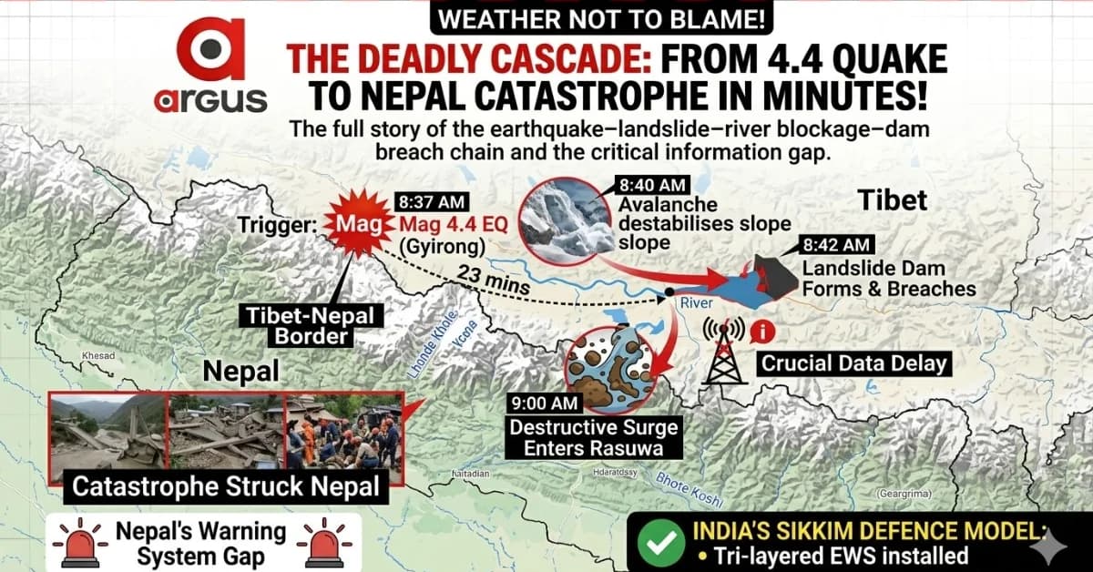
The answer, according to the technical sequence available, lies in a rapid earthquake–landslide–river blockage–dam breach cascade that unfolded upstream in Tibet. A comparatively moderate tremor was enough to destabilise an already fragile Himalayan slope. The collapse then triggered a chain reaction that gave downstream Nepal only minutes to react.

📱 Get Argus News App
✨The Trigger: A 4.4 Quake, Ice-Rock Avalanche and a Deadly 23-Minute Cascade
The first trigger came at 8:37 AM, when a magnitude 4.4 earthquake struck the high-altitude Gyirong region of Tibet, roughly 47 km north of Gosainkunda. The tremor was recorded and verified by the US Geological Survey (USGS).
Within minutes, the earthquake destabilised a massive ice-and-rock slope. The avalanche crashed into the upstream Lhende Khola, creating a temporary but highly unstable landslide dam. Water rapidly accumulated behind the blockage before the dam itself failed.
The timeline shows the extraordinary speed of the cascade:
8:37 AM: Magnitude 4.4 earthquake strikes.
Around 8:40 AM: Ice-and-rock avalanche destabilises the river corridor.
8:42 AM: A temporary landslide dam forms and rapidly breaches.
9:00 AM: The destructive surge enters Nepal’s Rasuwa district.
The flood was therefore not a conventional monsoon flood. It was, in effect, a sudden Landslide Dam Outburst Flood (LDOF) – a wall of water, mud and boulders unleashed by the failure of a freshly formed natural blockage.
The disaster exposed one of the most dangerous characteristics of the Himalayas: a relatively small earthquake can trigger a much larger secondary disaster when it strikes an unstable, ice- and permafrost-degraded mountain system.
China Could Have Prevented the Death Toll –But Why Didn’t It?
The earthquake itself could not have been stopped. Nor could the initial mountain collapse. But the catastrophic human consequences downstream were potentially preventable.
Data indicate that there was a roughly 23-minute warning window between the initial trigger and the flood’s destructive entry into Nepal. That is an extremely short period, but not necessarily useless in a narrow Himalayan valley. A machine-generated alarm, automatically transmitted across the border and immediately linked to sirens, could have prompted tourists, border personnel and residents to move to higher ground.
The core problem was the absence of an automated transboundary emergency warning loop.
China and Nepal may possess separate disaster-monitoring and hydrological systems, but they have no direct machine-to-machine mechanism capable of instantly transmitting an upstream landslide or river-blockage alert into Nepal’s disaster-management system. Instead, cross-border information remains trapped in diplomatic, bureaucratic and sovereign channels.
The other problem was infrastructure vulnerability. A major mountain collapse can simultaneously destroy roads, communication lines and power links –the very systems through which a manual warning may otherwise travel.
Thus, the crucial failure was not simply that China did not have information. It was that the regional system was not designed to convert that information into an automatic cross-border life-saving alert.
What Could Have Prevented This Catastrophe?
The answer lies in building a multi-layered disaster defence system, rather than relying on weather forecasts alone.
First, Nepal and China would need a real-time, automated cross-border telemetry arrangement. If a seismic station detects a major slope failure or a river sensor registers sudden blockage or explosive water-level change, an alert should automatically reach downstream disaster agencies without waiting for diplomatic communication.
Second, vulnerable Himalayan valleys need a combination of seismic and infrasound sensors capable of detecting the initial mountain collapse. These signals travel much faster than the flood itself.
Third, automated water-level and flow gauges are required at critical downstream points. Seismic systems can detect the collapse, but they cannot determine the actual volume and behaviour of water.
Finally, and most importantly, warnings must reach people. Automated sirens, SMS alerts, hydropower control-room protocols and mapped evacuation routes are essential.
In other words, the ideal sequence is:
Mountain Collapse → Seismic/Infrasound Detection → Water-Level Confirmation → Automated Alert → Dam Response → Village Sirens → Evacuation.
The Nepal tragedy shows that the absence of even one link can prove fatal.
What India Must Learn – And What It Has Already Deployed in Sikkim
For India, the warning is immediate. The Himalayas do not recognise political boundaries. A disaster beginning in Tibet can move through Nepal and eventually threaten downstream Indian river systems.
India has already begun building parts of such a defence architecture. The National Disaster Management Authority (NDMA), working with Sikkim and other agencies, is developing a tri-layered early-warning system in the wake of the devastating South Lhonak GLOF disaster.
In Sikkim, live Layer-1 telemetry monitoring equipment has been installed at South Lhonak Lake, the source of the 2023 disaster, and Shako Cho Lake. New Automatic Weather Stations have also been deployed at Kerang and Goma Chhu.
The system is designed around three levels:
Layer 1: High-altitude lake monitoring through weather stations, water-level sensors, cameras and satellite telemetry.
Layer 2: Mid-stream monitoring and dam integration, including radar-based flow gauges and automated operational responses.
Layer 3: Community-level warnings, including automated sirens, evacuation mapping and trained local response systems.
The Sikkim model is important because it recognises a critical reality: satellites alone cannot prevent sudden Himalayan disasters. A landslide dam can form and burst within minutes, while cloud cover and satellite revisit limitations may delay detection. Ground-based seismic, infrasound and water-level systems can potentially provide precious minutes of warning.
India has also deployed or piloted specialised systems in other Himalayan regions, including avalanche and infrasonic monitoring along the Zoji La axis, GLOF early-warning technology in Himachal Pradesh and automated monitoring in the Central Himalayas. The challenge now is scaling such technology across the enormous Himalayan hazard zone.
But India still faces the same geopolitical problem: it cannot freely place physical sensors inside the Tibetan catchments of rivers originating under Chinese control.
That makes a China–Nepal–India real-time Himalayan disaster-data protocol increasingly important.
Finally, What Did CWC Alert?
The Central Water Commission (CWC) issued a special transboundary flood advisory after the sudden rise in Nepal’s river system, warning downstream Indian authorities to remain prepared for the incoming surge.
According to it, the CWC projected a hydrological travel window of roughly 6 to 15 hours for the flood wave to move through the river system towards India. The advisory was transmitted to disaster-management authorities in Bihar and Uttar Pradesh, warning of a sudden flood surge routed through the downstream system.
The CWC’s warning highlighted a second lesson from the Nepal disaster: even when the originating catastrophe cannot be prevented, downstream impacts can still be managed if monitoring, forecasting and communication work fast enough.
The broader Himalayan lesson from August 26 is therefore stark. Clear skies do not mean safety. A catastrophic flood can begin not with rain, but with a mountain collapsing hundreds of kilometres upstream.
And
in such disasters, the difference between tragedy and survival may be
measured not in days – or even hours – but in a few minutes of
warning.
Also Read: Ocean Winner Rescue Mission Enters Its Most Crucial 72 Hours: Inside the High-Tech Hunt for 22 Missing Mariners in Paradip Sea| Special Report
Related Topics
Explore more stories