



Low-Pressure System May Bring Rain During Odisha’s Independence Day Flag Hoisting in Mayurbhanj, Balasore, Bhadrak, Keonjhar, Sundargarh, Jharsuguda & Sambalpur
Key Points
Bhubaneswar: Independence Day celebrations across Odisha may begin under cloudy and wet skies on August 15, as a low-pressure area over Jharkhand and Gangetic West Bengal is likely to influence the state’s weather during the morning flag-hoisting hours.
A glance at the NCMRWF, ECMWF pressure and rainfall charts indicate that the system, with central pressure estimated at around 997–1001 hPa, could pull deep monsoon westerlies and moisture-laden peripheral cloud bands across northern and central Odisha.
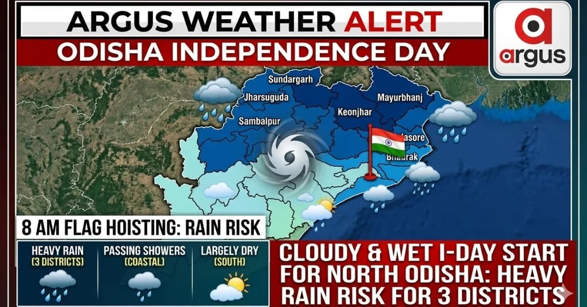
The forecast for around 8 AM on August 15, the period when Independence Day flag-hoisting ceremonies are generally held, shows a distinct north-south rainfall pattern.
Northern Odisha could see steady rain

📱 Get Argus News App
✨Mayurbhanj, Balasore, Bhadrak, Keonjhar, Sundargarh, Jharsuguda and Sambalpur are likely to have the highest probability of rain during the morning celebrations.
These districts are closest to the projected influence zone of the low-pressure system. Overcast conditions, along with light to moderate rain or drizzle, are therefore possible around the flag-hoisting hour.
Among them, Mayurbhanj and northern Balasore could be particularly vulnerable as the rain-bearing cloud belt remains close to the Odisha-Jharkhand-West Bengal region.
Bhubaneswar, Cuttack may get passing showers
The forecast does not indicate continuous rain across the entire coastal belt. Instead, Cuttack, Khordha, Puri, Jajpur and Kendrapara could see intermittent or scattered showers.
For Bhubaneswar, the possibility is more of a passing shower or drizzle around the morning period rather than a prolonged spell of heavy rain. Onshore moisture from the Bay of Bengal could help trigger localized rainfall.
This means Independence Day programmes may not necessarily face a complete washout in the capital, but organisers could still encounter brief wet spells during outdoor ceremonies.
Southern Odisha largely outside the core rain belt
The situation looks relatively less threatening across southern Odisha during the flag-hoisting hour.
Ganjam, Gajapati, Koraput, Malkangiri and Kalahandi are expected to remain largely dry, although cloudy skies and isolated light showers cannot be ruled out.
These districts are projected to remain outside the core morning rain band associated with the low-pressure system.
Three districts face heavy-rain risk
The bigger concern, however, emerges from the 24-hour accumulated rainfall forecast.
The NCMRWF model indicates a relatively narrow corridor of heavy rainfall extending into northern Odisha. The forecast rainfall band suggests 8 cm to 16 cm of accumulated rain in parts of the affected zone.
Three districts stand out:
- Mayurbhanj: Northern blocks bordering Jharkhand and West Bengal could receive the heaviest rainfall.
- Balasore: Heavy rain may be concentrated over northern and interior parts adjoining Mayurbhanj.
- Sundargarh: The northern belt close to Jharkhand could experience heavy spells as the system shifts westward later in the day.
Thus, while August 15 may begin with only scattered rain over much of Odisha, northern Odisha could witness a more sustained spell as the day progresses.
The key weather watch for Independence Day will therefore be the movement of the low-pressure centre and its associated rain band. A small shift in its track could alter the rainfall distribution significantly, particularly across northern Odisha.
For outdoor
flag-hoisting programmes, the 8 AM window appears most vulnerable in
northern districts, while Bhubaneswar and other coastal locations
face a comparatively lower risk of prolonged rainfall but cannot rule out brief
showers.
Also Read: Baleswar Flood Crisis Set to Deepen Next Week as Jalaka River Smashes All-Time Record | Exclusive
Related Topics
Explore more stories