



Baleswar Flood Crisis Set to Deepen Next Week as Jalaka River Smashes All-Time Record | Exclusive
Key Points
Bhubaneswar: The flood situation in northern Baleswar is showing signs of turning from a severe riverine crisis into a prolonged waterlogging emergency, with the Jalaka River breaching its all-time highest flood level at Mathani Bridge even as the neighbouring Subarnarekha continues to rise.
The Jalaka touched 7.38 metres at Mathani Road Bridge on Friday, surpassing its previous Highest Flood Level (HFL) of 7.31 metres recorded in September 2021. The river is now flowing 0.88 metres above its danger level of 6.50 metres, according to the Central Water Commission (CWC) reports.
What makes the situation more worrying is not merely the record level. The CWC's long-range forecast indicates that the Jalaka is likely to remain above its danger level through August 21, even as rainfall is expected to ease. That raises the prospect of floodwaters remaining trapped across the low-lying areas of northern Balasore long after the immediate rain spell weakens.
The emerging picture is therefore different from a conventional flood in which water rises rapidly and then recedes once rainfall stops.

📱 Get Argus News App
✨Here, the danger lies in how slowly the water may drain.
Jalaka breaks a record
The most significant development is at Mathani.
The Jalaka has crossed the highest level ever recorded at the location, rising to 7.38 metres, against the earlier HFL of 7.31 metres. The river's danger level is 6.50 metres, putting the current level well into the danger zone.
The significance of the breach goes beyond a statistical record.
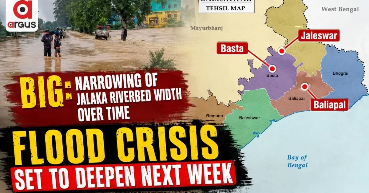
The Mathani area is an important link between the flood-prone blocks of Basta and Baliapal. Rising water has already resulted in severe overtopping of approach roads to the Basta-Baliapal road through Mathani Bridge, affecting communication and movement in the area.
The prolonged submergence is also threatening freshly transplanted Kharif paddy. The assessment puts the exposed agricultural area at more than 3,000 hectares, with prolonged waterlogging raising the possibility of extensive crop loss.
Why the next seven days matter
Ordinarily, a fall in rainfall would provide some relief to a flood-hit district.
The Jalaka forecast suggests otherwise.
The CWC's outlook extends up to August 21 and indicates that the river could remain above the 6.50-metre danger level throughout the forecast period. In practical terms, this means that even if fresh rainfall reduces, the flood threat will not disappear quickly.
This changes the nature of the emergency.
Instead of a short-lived flood peak, northern Balasore could face several days of stagnant or slowly draining floodwater, putting additional pressure on roads, agriculture, embankments and household assets.
And there is another river to watch.
Subarnarekha turns the flood into a compound threat
The Subarnarekha at Rajghat was recorded at 7.76 metres on August 14, with the river showing a rising trend.
The level was still below the Rajghat danger mark of 10.36 metres, with the warning level at 9.45 metres. But the rising trend assumes greater significance because the upstream Subarnarekha at Jamsolaghat had already crossed its danger mark, registering 49.42 metres and rising.
The CWC assessment also points to reservoir releases from the Galudih Barrage reaching Rajghat, potentially pushing water levels higher.
This creates the possibility of a compound flood situation in which the Jalaka and Subarnarekha are simultaneously carrying large volumes of water through northern Balasore's low-lying coastal landscape.
That is the central concern.
When two rivers create one flood problem
The danger is not simply that two rivers are rising.
It is that their floodwaters are interacting with the same low-lying coastal drainage system.
An assessment shows that the Subarnarekha and Jalaka as running through a broadly parallel coastal landscape before draining into the Bay of Bengal. As the Subarnarekha rises, the drainage capacity available to the Jalaka can be reduced, slowing the movement of Jalaka floodwater towards the sea.
In simple terms, the problem becomes:
record Jalaka level + rising Subarnarekha + coastal drainage constraints = prolonged inundation risk.
That is why the flood threat cannot be assessed by looking at the Jalaka or Subarnarekha separately.
The situation resembles a closing valve. The Jalaka has already crossed its historical maximum, while the Subarnarekha is building pressure from the north. If the downstream drainage remains constrained, floodwater can spread laterally across the low-lying terrain rather than rapidly escaping.
Four blocks emerge as the critical zone
The immediate geography of concern covers Basta, Baliapal, Jaleswar and Bhograi.
But the nature of the threat differs from block to block.
Jaleswar and Bhograi: Subarnarekha pressure
These areas are more directly exposed to the Subarnarekha's rising levels at Rajghat.
The assessment identifies low-lying areas and villages including Khalabadia, Kulha and Baunskhana, besides vulnerable portions of Jaleswar NAC.
Agricultural land is particularly exposed, while weak embankment stretches could come under increasing pressure if the river continues to rise.
Basta and Baliapal: The compound zone
The more complicated situation is developing around Basta and Baliapal.
These blocks sit in the area where the effects of both river systems can overlap. The assessment identifies Kudamansingh, Chaudhurykud, Srirampur, Nabara and Jamkunda among the vulnerable settlements.
The concern here is not simply fresh inundation.
It is the
possibility that water entering from one direction will encounter water coming
from another, leaving fewer escape routes and slowing drainage.
Watch Now: Balasore Flood News: Balasore & Jajpur Districts on High Alert
For communities already dealing with road overtopping and agricultural losses, that could turn several days of flooding into a much longer disruption.
This year's flood is different
The 2026 Balasore flood episode also stands out when compared with previous major flood years.
A historical assessment contrasts the current episode with the larger flood events of 2013, 2020 and 2022.
The 2013 crisis was associated with the wider impact of Cyclone Phailin and heavy rainfall.
The 2020 event involved widespread saturation of northern river basins and prolonged runoff. In 2022, a major Subarnarekha basin surge resulted in extensive inundation across low-lying areas of Baliapal, Bhograi and Jaleswar.
The 2026 pattern is different.
It is increasingly characterised by repeated flood spells, intense local rainfall and river-specific extremes, rather than one single massive basin-wide event.
The Jalaka's 7.38-metre reading at Mathani is the clearest example.
The river has broken its previous record even before the Subarnarekha has reached its own danger level at Rajghat.
That makes the event particularly important from a hydrological perspective. It suggests very BIG: Narrowing of the riverbed width over time.
Six flood spells are taking a toll
There is another dimension that is less visible in river-gauge readings: fatigue.
As per the assessment done, the Subarnarekha basin has already experienced its sixth flooding spell since June 2026. Repeated inundation means farmers and households have had little time to recover between successive events.
For farmers in Basta, Baliapal and Jaleswar, repeated submergence of newly transplanted paddy is particularly damaging.
The problem is no longer just one crop being lost in one flood.
Repeated flooding increases the financial burden of replanting, damages standing crops and reduces the time available for recovery before the next spell arrives.
That creates what can be described as agricultural flood fatigue.
The urban warning inside the rural flood
The Balasore crisis is not confined to riverbanks and agricultural fields.
The 2026 experience has also exposed the vulnerability of Balasore's urban drainage system. Reports point to repeated urban waterlogging, with the city experiencing five flooding episodes in a month and major roads becoming difficult to use after intense rainfall.
This creates two interconnected emergencies.
In the rural blocks, the immediate threat is prolonged riverine inundation.
In the urban areas, intense rainfall can overwhelm drainage capacity even without a major river overtopping.
Together, they make the district more vulnerable to repeated disruptions.
Balasore's flood warning has entered a new phase
The immediate headline is that the Jalaka has broken its all-time flood record at Mathani.
But the larger story is what happens after that record is broken.
A river crossing its HFL is usually a signal of extreme hydrological stress. In Balasore, that record surge is now occurring alongside a rising Subarnarekha and a constrained coastal drainage landscape.
That turns a river-level record into a prolonged flood-risk problem.
The next few days will therefore be critical for Basta, Baliapal, Jaleswar and Bhograi.
The question is no longer simply how high will the water rise?
It is increasingly how long will the water remain after the rain has gone?
For northern
Balasore, that could prove to be the defining danger of the August 2026 flood.
Also Read: Baitarani’s Dangerous Double Peak: Why August 19–21 Could Be the More Critical Flood Window For Bhadrak, Jajpur & Keonjhar| Exclusive
Related Topics
Explore more stories