Cyclone In June / Heatwave Relief From May 28: Bay of Bengal brewing Cyclone in June? Know its impact on Odisha, West Bengal and Monsoon 2026| Exclusive
Key Points
Bhubaneswar: With the heatwave peaking as May nears to end, taking a churn, the Bay of Bengal signalling a beacon for the heat-struck Indians. Indian Ocean weather matter changing fast.
The latest weather models have just dropped a bombshell, and if the model predictions hold true, Odisha’s weather fate may enter the Alt button over the next few days. The Bay of Bengal will be brewing a well-marked low by May end.
It seems the Bay of Bengal is waking up, scripting aggressive weather twist that seems may break the spine of the summer heat.
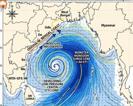
Models Show 40-Knot 'Monsoon Express'
The weather charts, earlier, had painted a picture of a confused, messy, and disorganized atmospheric setup, triggering fears that a weak system may pop up and might drift toward Myanmar, leaving Odisha dry, stranded, and baking under a prolonged "moisture trap."
Today’s latest model runs have completely junked that script.
IMD, NCMRWF Models Enter Alt Button
The IMD-GFS wind forecast reveals a textbook, high-velocity "low-level jet"—a massive highway of southwesterly winds—surging across the equator and slamming directly into the Bay of Bengal.
Far from being fragmented, a powerful wind core hitting a fierce 30 to 40 knots (up to 75 km/h) is seen consolidating in the central and southern Bay.
The speed suggests no longer a weak, drifting disturbance. It is a full-throttle monsoon engine primed to pump trillions of gallons of oceanic moisture straight toward the eastern coast of India.
Crucial Charts: NCMRWF Model Points Pressure at Eastern Coast
Complementing the IMD model predictions, the high-resolution NCMRWF model shows a distinct, deeply anchored low-pressure trough carving its way through the northwest Bay of Bengal.
The geopotential height contours are firmly aligning near the Head Bay, stretching dangerously close to the Odisha and West Bengal coasts. Rather than diverting moisture away toward Southeast Asia, the latest dynamics show the atmospheric conveyor belt pouring over directly at eastern India.
📱 Get Argus News App
✨When Will the Heatwave Die?
For residents on the ground enduring the oppressive heat stress, the million-dollar question is: When does the misery end?
The transition will be intense but quick. The incoming system is pulling in an immense amount of moisture, the next 48 to 72 hours will feel incredibly stifling.
Coastal and interior pockets of Odisha will face severe humidity and uncomfortable "warm night" conditions through May 26–27.
Pre-Monsoon Show On
Latest projections confirm that widespread pre-monsoon thunderstorms will rapidly multiply.
A welcome 2deg C to 3 deg C drop in maximum temperatures is locked in for Odisha between May 27 and May 29, effectively putting an end to the extreme heatwave cycle as the skies open up
Cyclone Question: Is a Named Storm Brewing?
With the Bay of Bengal churning so aggressively, chatter about a potential cyclone is naturally returning to the region.
Right now, the atmospheric environment is highly favorable for the rapid birth of a Low-Pressure Area, followed by a well-defined cyclonic circulation.
However, because the system is deeply embedded within a massive, fast-moving monsoon current, it faces a race against time. For a system to intensify into a severe named cyclone, it requires a more isolated, tightly wound core.
While history cautions that the ultra-warm waters of the Bay can trigger rapid intensification if a core consolidates, the current setup looks less like a classic destructive cyclone and more like a brutally powerful, widespread monsoon depression.
The Verdict: Odisha’s Monsoon Destiny
The next few days will mark a historic seasonal shift for the state. Model predictions suggest Odisha is about to transition from a dry, scorching pre-monsoon phase straight into a high-energy, wet monsoon launch.
While the
incoming stormy weather will bring gusty winds and heavy downpours that require
municipal level vigilance, it brings the one thing millions have been praying
for: curtains down on the severe Heat Wave theatre.
Also Read: Severe Weather Alert / Extreme Loo Alert: Why Western Odisha, 7 States Face Burning 35 km/h Hot Winds Next 72 Hours| Exclusive
Related Topics
Explore more stories