Severe Weather Alert / Extreme Loo Alert: Why Western Odisha, 7 States Face Burning 35 km/h Hot Winds Next 72 Hours| Exclusive
Key Points
Bhubaneswar: Torrid 72 hours from Sunday. 35kmph hot wind to sweep the states of Rajasthan, Punjab, Haryana, west Uttar Pradesh, east MP, and some parts of Odisha. Day and night seem to unfold untold miseries on the people dwelling in the region.
This cruel turn of weather has evolved following a massive atmospheric "heat engine" that has locked itself over the Indian subcontinent, threatening to trigger some of the most punishing "Loo" conditions of the season.
While common predictive weather summaries merely show rising temperatures, raw deterministic meteorology maps tell a far more alarming story.
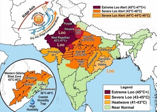
The Cruel Summer Ridge
The latest IMD-GFS and NCMRWF weather models reveal that a giant atmospheric "ridge" has aligned perfectly over West-Central India, acting as a dynamic pump pushing superheated, dry continental air across the country.
If you are living in Northwest India, Central India, or Western Odisha, you are directly in the line of fire of this invisible, high-velocity heat wave.
The Science of the 'Loo': What Raw Weather Maps Reveal
This is not standard summer heating; it is an aggressive atmospheric advection.
An examination of the geopotential height contours reveals a pronounced northward bulging—a dynamic atmospheric ridge—stretching from the Arabian Sea up through West-Central India. This ridge compresses and accelerates dry air coming out of the core desert zones, sending it racing down-gradient toward the east coast.
📱 Get Argus News App
✨According to the IMD model, these hot, dry westerly winds are clocking speeds of 15 to 20 knots (approximately 28 to 37 km/h) at lower atmospheric levels. This means the hot air isn't just sitting over cities; it is actively sweeping through them like a blast furnace, rapidly accelerating moisture loss from the soil and the human body.
Odisha Weather: Why Western Districts Sit on the 'Fall Side' of the Danger Zone
For Odisha, the state’s unique geography is creating a sharp, dangerous split. The raw maps show that Odisha is positioned directly on the "fall side" of the atmospheric ridge.
Districts
like *Sambalpur, Jharsuguda, Bolangir, Sonepur, and Sundargarh* have no
geographic shield against this Central Indian air mass. The westerlies will
crash directly into these regions at 30+ km/h. Combined with clear local skies,
day temperatures in Interior Odisha are projected to skyrocket between *43°C
and 46°C* over the next few days.
| Western Odisha |
Coastal Odisha |
| Sambalpur, Bolangir, Sonepur, interior Odisha |
Bhubaneswar, Cuttack, Puri etc |
| Raw Blast Mercury to hover between 43-46 degC |
Humid Air Trap, Mercury range - 38 - 40 deg C |
The Coastal Humidity Trap
Coastal
Odisha (Bhubaneswar, Cuttack, Puri and adjoining places) sits right where these fiery westerlies collide with weak, shallow
marine air from the Bay of Bengal.
While the westerlies will lose some speed here, preventing the raw 45°C blast, they will trap intense moisture. Expect day temperatures between *38°C and 40 deg C, but the extreme humidity will make the "RealFeel" index touch a suffocating **48 deg C*.
National Impact: The 7 States Facing the Extreme Loo
Odisha is not alone. The high-momentum advection of dry, continental air is bringing severe to severe heatwave warnings to a massive swath of the country:
| Region/State |
Expected Wind Nature |
Max Temp Outlook |
Alert |
| West Rajasthan, Punjab |
Intense, dry desert westerlies |
45 - 47 Deg C |
Red Alert |
| Haryana, Delhi, West UP |
High velocity gusty Loo |
44 - 46 deg C |
Orange/Red |
| Vidarbha, East MP |
Core Rideg-compressed heat |
45-46 deg C |
Red Alert |
| Chhattisgrah, Jharkhand |
Continental westerly Advection |
43 - 45 deg C |
Orange Alert |
| Western Interior Odisha |
Down-slope ridge wind (30+kmph) |
43 - 46 deg C |
Orange Alert |
Related Topics
Explore more stories