Severe Heatwave Forecast / Rajasthan to Vidarbha Brace for Peak Severe Heatwave by May 31; 50 kmph Winds Likely Along Coastal Odisha from May 25| Exclusive
Key Points
Bhubaneswar: The sun appears to be breathing fire across large parts of India, with Odisha enduring another punishing day of scorching conditions on Thursday.
Afternoons
across the State have turned into simmering cauldrons, and weather models
suggest there may be little respite before May 31.
Odisha’s traditional heat hotspot, Jharsuguda, recorded a blistering 44.4°C at
2:30 PM Thursday, after touching nearly 46°C on Wednesday. The State capital,
Bhubaneswar, also remained under intense thermal stress, with the mercury
climbing to 41.6°C.
Even as severe heatwave-like conditions tighten their grip over Odisha and much of India, meteorological charts present a striking contradiction — the southwest monsoon over the Bay of Bengal is simultaneously showing vigorous progress.
This unusual overlap of advancing monsoon winds and intensifying continental heat has created a dramatic weather divide across the subcontinent.
The coming 10 days could determine whether India experiences a full-scale “heat shock” or an early monsoon-driven atmospheric turnaround along parts of the coast.
Odisha Split Between Furnace Heat and Sultry Coastal Instability
Weather charts indicate a sharp meteorological contrast across Odisha. While a low-level trough along the eastern coastline is expected to marginally suppress daytime temperatures over coastal districts, western and interior Odisha remain trapped under a dangerous heat dome.
According to the latest IMD-GFS deterministic model guidance, a powerful upper-air ridge stretching across northwest and central India is generating intense atmospheric subsidence — a process in which sinking air compresses and heats rapidly. This has created a massive continental heat core extending from Rajasthan through Madhya Pradesh into central India.
Western Odisha lies directly along the eastern edge of this thermal corridor, exposing districts such as Jharsuguda, Sambalpur, Bolangir, Nuapada and Sonepur to prolonged severe heatwave conditions.
Why Coastal Odisha May Cool Slightly While the West Continues to Boil
📱 Get Argus News App
✨Meteorological models show two competing atmospheric systems shaping India’s weather pattern.
The Ridge Effect: A dominant upper-level ridge over northwest and central India is preventing cloud formation and accelerating surface heating.
This is pushing temperatures across Rajasthan, Haryana, Delhi, Madhya Pradesh and adjoining interiors well above seasonal averages.
The Coastal Trough: At the lower atmospheric level, a wind discontinuity and trough line extending from Tamil Nadu through Andhra Pradesh up to coastal Odisha is pulling moist marine air inland from the Bay of Bengal.
This marine intrusion is expected to provide partial temperature relief over coastal Odisha from May 24 onward.
However, the relief may remain deceptive. While temperatures could settle between 36°C and 38°C in Bhubaneswar, Cuttack, Puri and Balasore, humidity levels are likely to surge sharply, resulting in oppressive “feels-like” conditions.
Model runs also indicate the possibility of gusty winds reaching 40–50 kmph, accompanied by intense lightning and thunderstorm activity along coastal Odisha beginning around May 25.
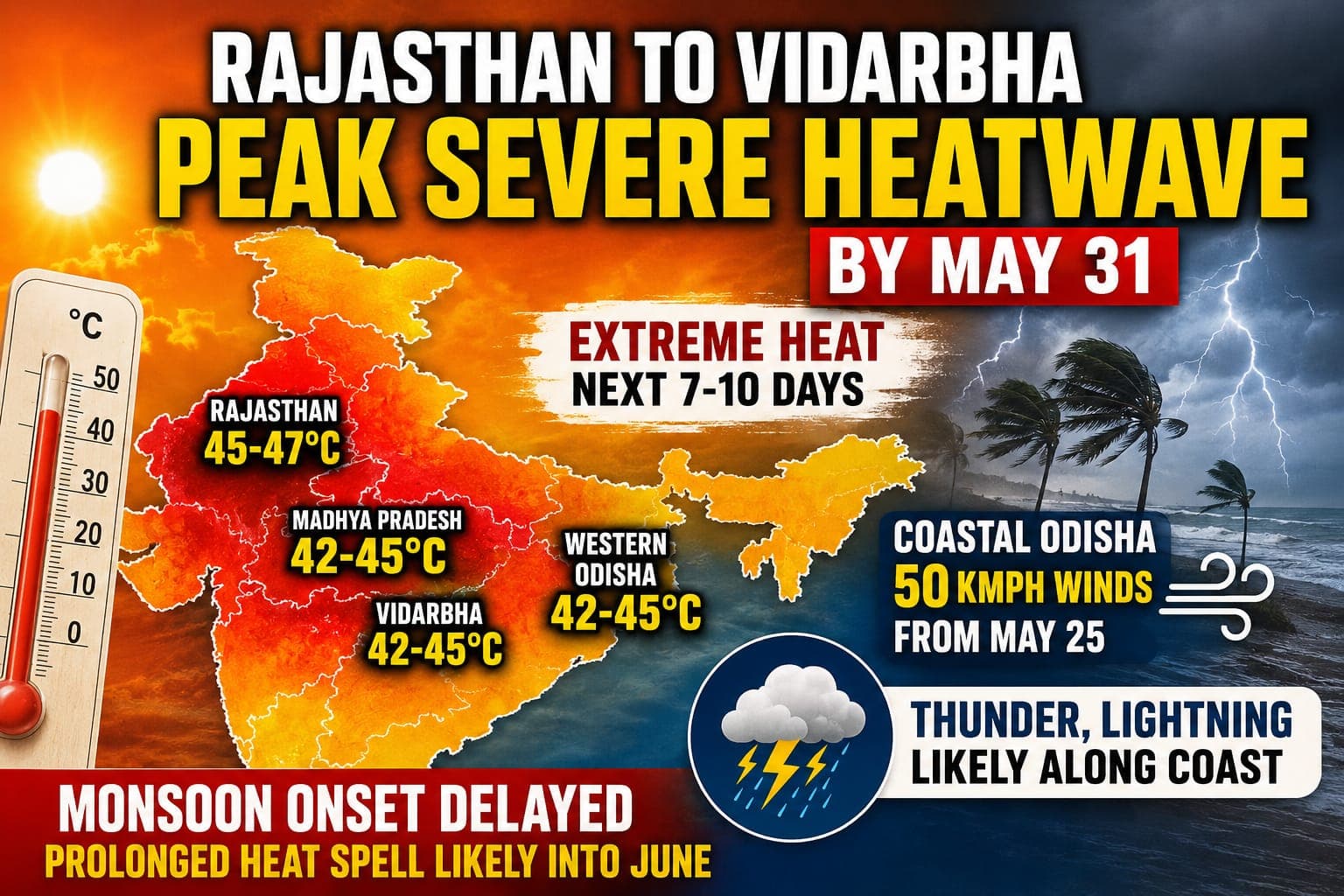
Severe Heatwave to Intensify Nationally
The broader
national outlook remains alarming. Forecast models indicate that the heat core
will intensify further over northwest and central India through the final week
of May, with the most severe phase expected around May 31.
| Region Wise Heat Outlook |
Peak Temperature Expected |
Forecast Trend |
| Rajasthan, Delhi , Haryana |
45 deg C to 47 dec + |
Severe escalation likely over next 10 days |
| Madhya Pradesh, Vidarbha |
42 deg C to 45 deg C |
Persistent ridge-driven heatwave for 7-10 days. |
| Telangana, Rayalseema |
42 deg C to 45 deg C |
Immediate 48-hr peak before gradual shift |
| Western Odisha |
42 deg C to 45 deg C |
Severe heatwave likely to persist through month end |
| Coastal Odisha |
36 deg C to 38 deg C |
Slight cooling but rising humidity and storm activities |
Monsoon
Progress Slows Despite Bay Activity
Compounding the heat stress is the
uncertain pace of monsoon advancement.
Forecast charts suggest that the
cross-equatorial flow over the Indian Ocean is yet to consolidate into the
deep, organised westerly circulation required for a decisive monsoon onset over
Kerala.
In effect, while the Bay of Bengal branch shows signs of activity, the
broader monsoon engine remains structurally weak. This delay is critical
because, without a robust monsoon surge, there is little atmospheric mechanism
available to dismantle the massive heat ridge parked over northern and central
India.
As a result, a vast swathe of the country — stretching from Rajasthan to
Vidarbha and into interior Odisha — may remain trapped under prolonged and
dangerous heat conditions heading into June.
Also Read: Monsoon 2026 Forecast / Odisha to Witness Intense Thunderstorms after May 26; Monsoon Kerala Onset Delays, Early Onset over Northeastern States|Exclusive
Related Topics
Explore more stories