



EXCLUSIVE| Overcast But No Rain? Why Cyclone Arnab Is Shielding Odisha Districts Till Tuesday—Bhubaneswar, Cuttack, Puri, Berhampur Timeline

Key Points
Cyclone Arnab is driving dense rain-bearing clouds across southern and coastal Odisha, with heavy downpours set to begin by Tuesday afternoon.
Bhubaneswar and Cuttack face high urban flood risks due to continuous convective moisture bands streaming from the Bay of Bengal.
Peak rainfall intensity is expected from October 27 night through October 28 across Ganjam, Puri, Khordha, and surrounding districts.
Bhubaneswar: With Cyclone Arnab now positioned closer to Gopalpur, Odisha (580 km) than its projected landfall region of Kakinada, Andhra Pradesh (690 km), the skylines of Ganjam, Gajapati, and Rayagada have already been intruded by the cyclone's rain-bearing cloud bands. However, as of now, rainfall activities are yet to begin in these districts – and the dry spell is not going to break immediately.
In weather science,
the absence of rain despite heavy cloud cover is attributed to a wedge of
mid-level dry air. As Cyclone Arnab closes in, it will continuously pump
massive amounts of tropical moisture into the region. This incoming moisture
will gradually overpower and "eat away" the dry air layer from the
top down.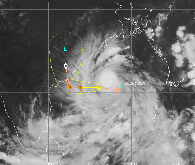
Consequently, actual rain will begin breaking through to the surface by Tuesday afternoon, hitting Ganjam and Gajapati first as light to moderate intermittent showers.

📱 Get Argus News App
✨As night falls, these light showers will intensify. The arrival of the deep, core convective bands will open the gates for continuous, high-intensity heavy to very heavy rainfall across Ganjam, Gajapati, and Rayagada heading into Wednesday morning.
Timeline: When Clouds Cover the Cities
Satellite images show as massive outer cloud structure trailing north and east of the system’s core, the clouds will arrive in distinct stages well before the actual core of the storm makes landfall.
· Berhampur: Peripheral thin clouds and high-altitude bands are already arriving (evening of October 26). The thick, rain-bearing dense cloud shield will fully blanket the city by evening on October 27, continuing through October 28
· Berhampur: JTWC data shows Berhampur lies closest to the northern edge of the storm’s core wind radii. Therefore, the city may experience a combination of severe rainfall and strong wind.
· Expect relentless, torrential downpours capable of causing immediate flash flooding in urban areas and low-lying agricultural zones. Sustained peripheral winds touching 55 km/h, leading to tree falls and power disruptions.
· Puri, Bhubaneswar, & Cuttack: Light cloud cover will filter in tonight. The heavy, dark convective cloud bands will completely lock over the twin cities and Puri by the night of October 27 through the morning of October 28.
· Puri: Will be battered by high-energy maritime rain bands. Torrential downpours combined with strong onshore winds (50–65 km/h) will result in very rough seas, minor coastal surge constraints, and localized flooding on Oct 27 night through Oct 28.
· Cloud & Rain Impact: Very High. The pilgrim town will be directly impacted by the right-hand moisture convergence zone of the cloud arm sweeping off the warm waters of the Bay of Bengal. This means dense, low-hanging rain clouds will dump continuous, high-intensity rain starting October 27 through October 29. Storm surge combined with heavy rains may cause drainage backflow near the coast.
Skyline Watch: Bhubaneswar & Cuttack
Satellite images show, while Cyclone Arnab’s core high-wind eye wall will make landfall further south near Yanam/Kakinada (Andhra Pradesh), the unique, asymmetric cloud structure of the storm means that coastal and capital Odisha will be experiencing a severe meteorological decoupling.
The storm's dense, high-moisture outer cloud arm will swing northward over the Bay of Bengal, acting like a continuous atmospheric vacuum. For Bhubaneswar, and Cuttack, this means facing a massive, prolonged deluge rather than destructive landfall-level core winds.
When Cyclone Arnab sits over Malkangiri (by afternoon or evening) on Oct 28, as such systems keep rotating counter-clockwise, with the center over Malkangiri, the entire right-hand side of the storm would then sits directly over the warm waters of the Bay of Bengal. It will act like a giant atmospheric vacuum, sucking ocean moisture and hurling it directly onto coastal and central Odisha.
Bhubaneswar & Cuttack (Twin Cities)
· Cloud & Rain Impact: High Urban Flood Risk. The twin cities are positioned perfectly underneath the "right arm" convective band of the cyclone. As the cyclone slows down down south, it acts like a massive pump, sending train after train of heavy rain clouds over Khordha and Cuttack districts. The primary threat here is localized urban flooding and waterlogging due to the sheer volume of water dumped over a 36-to-48-hour window.
· Wind Impact: Moderate. The passing cloud bands will trigger intermittent, sharp wind gusts between 40–45 km/h, particularly during intense downpours.
Timeline of Cloud Impacts
Timeline of Cloud Impacts
·
October 26 (Evening) to October 27 (Morning): Sky completely overcasts. Ambient humidity spikes sharply, with initial
scattered rain bands arriving in Berhampur and Puri.
· October 27 (Night) to October 28 (All Day): Peak Rain Intensity. The heaviest cloud mass covers all four cities. Expect non-stop heavy rainfall, low visibility, and gusty winds peaking while the storm makes landfall down south.
· October 29: Clouds begin to fragment as the cyclone breaks up over the inland mountains, transitioning to steady, lighter rain and clearing winds.
· October 29 (Thursday) Inland Migration: The system weakens into a deep depression as it cuts inland towards Chhattisgarh. Heavy rainfall shifts toward western and interior Odisha districts before subsiding significantly on October 30.