



EXCLUSIVE | Deep Depression Track Update: Kalingapatnam Emerging as Landfall Zone; When, Where Will Odisha Feel the First Impact?
Key Points
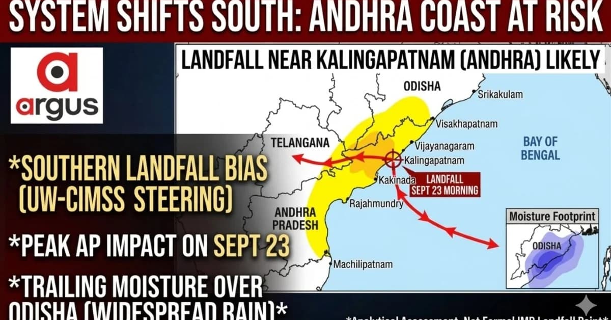
Landfall Prediction: Analytical indicators and UW-CIMSS steering winds point to a likely deep depression landfall near Kalingapatnam, Andhra Pradesh, on Wednesday morning, September 23.
Andhra Pradesh Impact: Srikakulam, Vizianagaram, and Visakhapatnam face the core weather threat, featuring extremely heavy rainfall and squally winds gusting up to 70 kmph.
Odisha's Weather Shield: Odisha will experience a multi-stage rainfall impact driven by a trailing northern moisture canopy rather than direct landfall winds.
Bhubaneswar: The developing Bay of Bengal system is increasingly showing a southern landfall bias, with the combined reading of the India Meteorological Department's latest warning chronology and UW-CIMSS mid-level steering winds pointing towards a likely crossing near Kalingapatnam in Andhra Pradesh's Srikakulam district on Wednesday morning, September 23.
The important distinction is that this is an analytical track assessment, rather than a formally declared IMD landfall point.
IMD's September 21 update says the well-marked low-pressure area over the northwest Bay is very likely to become a depression and subsequently a deep depression during the next 48 hours.
At the same time, its warning sequence places the strongest weather over Coastal Andhra ahead of the peak Odisha phase: Coastal Andhra has been put under a very heavy-rain warning on September 22 and extremely heavy rain with strong winds on September 23 and 24.

📱 Get Argus News App
✨Odisha's warning sequence is slightly displaced in time, with very heavy rain on September 22, extremely heavy rain on September 23–24 and very heavy rain on September 25.
That timing becomes significant when read against the UW-CIMSS 850–500 hPa steering field to derive this analysis.
The steering flow is keeping the system on a southern corridor
The CIMSS low-to-mid-level wind-barb chart shows a broad easterly to east-southeasterly flow pushing towards the west-northwest.
For a system whose movement is being determined largely by the lower and middle troposphere, this provides a fairly coherent steering corridor towards the north Andhra–south Odisha sector.
The CIMSS analysis places the system inside a very low vertical-wind-shear environment, with the centre lying within a 0–5-knot shear zone.
The
shear-tendency chart also indicates a reduction of roughly 5–10
knots during the preceding 24 hours
around the system. That combination favours preservation of the
circulation and a gradual organisation towards deep-depression
intensity.
More importantly for the track, the 850-500 hPa
steering analysis shows the dominant flow running west-northwestwards
towards the coast, while the northern part of the steering
environment offers resistance to an early northward turn. The
combined interpretation therefore shifts the landfall probability
towards Kalingapatnam/Srikakulam
rather than a Odisha landfall.
The emerging track
The likely sequence, based on the combined indicators, is:
Bay of Bengal → north Andhra coast near Kalingapatnam → west-northwest inland → Telangana → gradual weakening/turn towards north.
This explains an important feature of the rainfall forecast: Andhra Pradesh receives the first major core impact, while Odisha remains under the northern and northeastern moisture shield for a longer period.
The analysis, further, puts the likely landfall around Kalingapatnam on September 23, followed by an inland west-northwest trajectory towards Telangana.
What the landfall could mean for Andhra Pradesh
The direct landfall zone would experience the strongest combination of rain, thunderstorms and squally winds.
IMD's current Coastal Andhra warning calls for extremely heavy rain on September 23 and 24, accompanied by thunderstorms/lightning and strong surface winds.
The IMD weather assessment places the strongest squalls around 50–60 kmph, gusting to about 70 kmph in the core coastal impact zone.
District-wise impact assessment — Andhra Pradesh
|
Andhra Pradesh district/sector |
Most active period |
Rainfall character |
Wind/weather impact |
Expected concern |
|---|---|---|---|---|
|
Srikakulam |
Sept 22–24; peak Sept 23 |
Very heavy to extremely heavy |
Squally winds; around 50–60 kmph, gusting to 70 kmph near core |
Direct/near-direct landfall impact; waterlogging, local flooding |
|
Vizianagaram |
Sept 22–24 |
Very heavy to extremely heavy |
Strong surface winds and thunderstorms |
Heavy runoff, tree/utility disruption |
|
Visakhapatnam |
Sept 22–24 |
Heavy to very heavy, locally higher |
Squalls/thunderstorms |
Urban drainage stress and coastal disruption |
|
North Coastal Andhra |
Sept 22–24 |
Very heavy to extremely heavy |
Strong winds/thundersqualls |
Broad coastal rain shield and rough conditions |
|
Rayalaseema |
Sept 21–25 |
Mainly heavy rain/thunderstorms |
Strong surface winds |
Inland rain as system influence expands westward |
The Rayalaseema warning is notably different from Coastal Andhra: IMD currently maintains thunderstorms and strong surface winds through September 25, but without the same extremely-heavy-rain signal seen over Coastal Andhra.
Odisha: rain arrives in waves, not as a single landfall burst
Odisha's weather story is therefore likely to be less about direct landfall winds and more about the large moisture canopy trailing north and northeast of the inland-moving depression.
The CIMSS water-vapour interpretation shows the moisture shield extending well north of the circulation. That is why the first significant rain develops in southern Odisha before progressively expanding into central and northern districts.
Odisha district-wise rainfall timeline
|
Odisha districts |
Rain arrival |
Peak window |
Rainfall potential |
Wind/other impact |
|---|---|---|---|---|
|
Ganjam, Gajapati |
Sept 22 |
Sept 22–23 |
Extremely heavy, locally >200 mm |
Squalls 50–60 kmph, gusting to 70 kmph; coastal flooding risk |
|
Malkangiri, Koraput, Rayagada |
Sept 22 afternoon/night |
Sept 23–24 |
Heavy to very heavy, 115–200 mm potential |
Rapid stream rise, flash-flood risk in hilly terrain |
|
Puri, Jagatsinghpur |
Sept 22 night |
Sept 23–24 |
Heavy to very heavy |
Persistent rain, drainage congestion |
|
Nayagarh, Kandhamal, Nabarangpur, Kalahandi, Nuapada |
Sept 23 |
Sept 23–25 |
Heavy, around 70–115 mm potential |
Prolonged rain as system tracks inland |
|
Boudh, Angul, Dhenkanal |
Sept 23 |
Sept 24–25 |
Heavy |
Catchment inflow and local drainage stress |
|
Bolangir, Sonepur, Bargarh, Sambalpur |
Sept 24 |
Sept 24–26 |
Moderate to heavy |
Runoff accumulation as system weakens/turns |
|
Keonjhar, Jharsuguda, Sundargarh, Deogarh, Mayurbhanj |
Sept 24 night |
Sept 25–26 |
Mainly moderate, locally heavy |
Residual rain from weakening system |
These timings follow the moisture-footprint assessment, which places the earliest persistent rain over Ganjam-Gajapati, followed by the southern interior and then progressively central and northern Odisha.
September 22: South Odisha becomes the first impact zone
The first meaningful phase begins Tuesday.
Ganjam and Gajapati are expected to see the earliest persistent rain, while Malkangiri, Koraput and Rayagada can begin receiving significant rain from Tuesday afternoon into the night.
This is important because the system itself may still be offshore or approaching the Andhra coast, yet its moisture field is already reaching Odisha.
September 23: the system crosses Andhra while southern Odisha enters the core rain phase
Wednesday is likely to become the key transition day.
If the centre crosses close to Kalingapatnam in the morning, the immediate coastal Andhra sector will receive the strongest wind and rainfall impact. But over Odisha, the southern districts can remain beneath the northern moisture conveyor.
The assessment places Ganjam-Gajapati at the highest rainfall risk, with the southern interior districts also entering a heavy to very heavy rainfall phase.
September 24: Odisha's wider rainfall peak
Thursday could become the most important rainfall day for a large part of Odisha.
By then, the depression would be inland, but its circulation and moisture field would continue feeding rainbands across Odisha. The system's west-northwest movement towards Telangana means that Odisha is likely to remain on the northern side of the circulation.
This is also consistent with IMD's current warning schedule, which keeps extremely heavy rainfall over Odisha on September 24, even as the direct landfall phase is occurring farther south in Andhra Pradesh.
September 25–26: the rain shifts inland and northward
By Friday, the system should be considerably farther inland.
The rainfall focus consequently shifts from the southern districts towards western and interior Odisha. Bolangir, Sonepur, Bargarh and Sambalpur could remain wet through September 26, while northern districts see the weakening system's residual influence.
The critical point is that landfall does not mean the end of Odisha's weather threat.
The track through Telangana would keep the moisture plume active over Odisha even after the circulation itself has moved away from the coast.
The larger weather picture
The emerging scenario is therefore a two-stage impact:
Stage 1 – September 22–23: Southern Odisha and north Coastal Andhra receive the first and strongest coastal-sector weather.
Stage 2 – September 24–26: As the depression moves inland towards Telangana and subsequently curves north, its moisture field continues to generate widespread rain across Odisha.
That
makes the likely Kalingapatnam landfall particularly important: the
centre may stay south of Odisha, but the rainfall footprint will not.
Also Read: Exclusive | Bay of Bengal System Set to Form Powerful Deep Depression, Not Cyclone; Landfall Expected Between Srikakulam and Chhatrapur
Related Topics
Explore more stories