



Exclusive | Bay of Bengal System Set to Form Powerful Deep Depression, Not Cyclone; Landfall Expected Between Srikakulam and Chhatrapur
Key Points
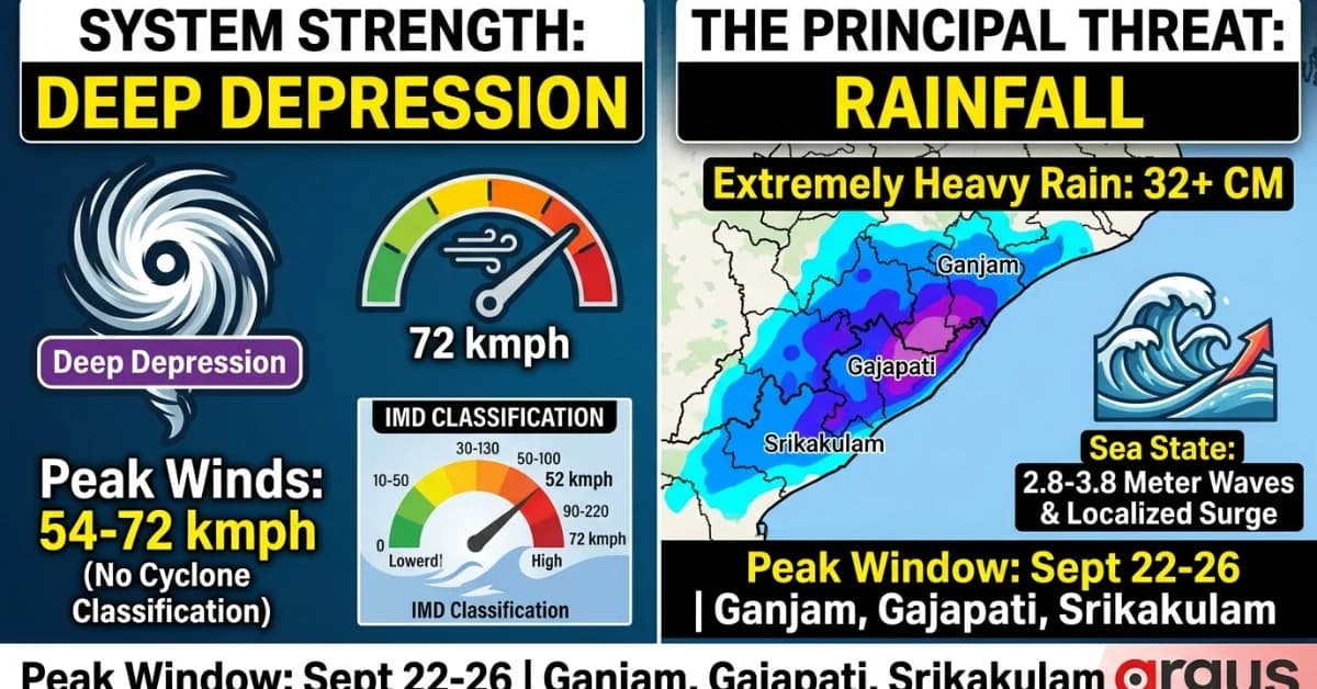
The developing Bay of Bengal weather system is projected to intensify into a powerful Deep Depression rather than a full Cyclonic Storm.
The primary threats are widespread heavy rainfall exceeding 32 cm, flash floods, rough seas (waves up to 3.8 metres), and localized storm surges rather than destructive winds.
The high-impact consensus corridor spans the Ganjam–Gajapati coast of Odisha and adjoining Srikakulam in Andhra Pradesh, with peak impacts expected between September 22 and 26.
Bhubaneswar: A comprehensive reading of the latest INCOIS, NCMRWF Ensemble and ECMWF model guidance points to a significant but important distinction in the developing Bay of Bengal system: it is increasingly likely to intensify into a powerful Deep Depression, rather than cross the threshold to become a Cyclonic Storm.
The models broadly agree on the system moving towards the South Odisha–North Andhra Pradesh coastal sector, but differ on one crucial question – whether its core crosses the coast around the Odisha-Andhra border or remains just offshore while tracking southward along the Andhra coast.
The distinction matters because the system's principal threat is increasingly emerging as rainfall, flooding, rough seas and strong squally winds, rather than the tightly concentrated destructive wind field normally associated with a mature cyclonic storm.
The model analysis puts the peak wind field around 54–72 kmph, while the system's projected movement and rainfall footprint indicate a much wider hydrometeorological impact zone. Under the IMD classification, sustained winds of at least 34 knots, or about 62 kmph, are required for a system to be classified as a Cyclonic Storm.

📱 Get Argus News App
✨Three Models, One Broad Corridor – But Different Landfall Solutions
The most striking feature of the current guidance is that the models are not diverging widely on the broad geographical corridor. All three point towards South Odisha and North Andhra Pradesh.
What they disagree on is the exact behaviour close to the coast.
|
Model |
Projected track / landfall zone |
Expected behaviour |
Timing indicated |
|---|
INCOIS
17.5°N–18.5°N, largely offshore and parallel to North Andhra coast, around the Kakinada–Visakhapatnam sector
Core remains offshore and skims southward; Odisha receives substantial peripheral/trailing rainfall and wind effects
Sept 23 morning
NCMRWF-Ensemble
19.0°N, 84.5°E, around the Ganjam–Srikakulam border sector
More direct coastal crossing followed by west-northwestward inland movement
Sept 23
ECMWF
18.5°N–19.5°N, covering South Odisha coast and North Andhra Pradesh
Core impact concentrated around Ganjam/Gajapati–Srikakulam sector
Sept 23–24
The model comparison reveals that the NCMRWF deterministic crossing at 19.0°N, 84.5°E, geographically around Ganjam district and immediately north of the Srikakulam boundary. ECMWF's ensemble envelope is broader, extending from 18.5°N to 19.5°N. INCOIS, meanwhile, keeps the core farther south and offshore.
The Consensus: Ganjam–Gajapati to Northern Srikakulam Sector
Putting the three model solutions together, the most consistent high-impact corridor is the South Odisha–North Andhra Pradesh border belt, rather than the central or northern Odisha coast.
The most probable core-impact/landfall sector from the combined guidance is therefore:
Ganjam–Gajapati coast of Odisha adjoining northern Srikakulam in Andhra Pradesh.
This should, however, be read as a model-consensus zone, not a fixed point prediction. The INCOIS solution remains notably farther south and offshore, while NCMRWF's deterministic solution brings the centre directly across the coast.
|
Consensus assessment |
Most likely zone |
|---|---|
|
Broad corridor |
South Odisha–North Andhra Pradesh |
|
Highest-consistency coastal belt |
Ganjam–Gajapati–Srikakulam |
|
NCMRWF deterministic crossing |
19.0°N, 84.5°E |
|
ECMWF ensemble envelope |
18.5°N–19.5°N |
|
INCOIS alternate solution |
Offshore, parallel to North Andhra coast |
|
Peak period |
Sept 22–25 |
|
Likely intensity |
Deep Depression |
INCOIS Sea-State Signal: The Ocean May Turn Hazardous Before Landfall
The atmospheric classification may remain below Cyclonic Storm strength, but that does not translate into benign marine conditions.
The INCOIS Ocean State Forecast shows a significant escalation in sea-state conditions along the Gopalpur–Kalingapatnam stretch between September 22 and 26.
The significant wave height is projected to rise to approximately 2.8–3.8 metres, or roughly 9–12.5 feet, particularly in the nearshore breaker zone.
The timing is important. The strongest swell and wave activity is projected from Tuesday night, September 22, into Thursday morning, September 23, broadly coinciding with the system's closest approach to the South Odisha–North Andhra coast.
Tide + Surge Could Become A Localised Coastal Problem
The INCOIS assessment also points to a 0.5–1.0 metre rise above astronomical tide associated with the system near the projected 19°N coastal crossing.
The vulnerable locations identified, therefore, include Gopalpur, Chhatrapur and the Kalingapatnam port sector, particularly during high-tide windows.
That means the coastal risk cannot be assessed only through wind speed. Even without a Cyclonic Storm classification, the combination of rough seas + swell + astronomical tide + localised surge can produce temporary saltwater inundation in low-lying coastal pockets.
|
INCOIS marine parameter |
Forecast signal |
|---|---|
|
Marine sector |
Gopalpur–Kalingapatnam |
|
Significant wave height |
2.8–3.8 m |
|
Peak swell window |
Sept 22 night–Sept 23 morning |
|
Additional surge above astronomical tide |
0.5–1.0 m |
|
Most vulnerable pockets |
Gopalpur, Chhatrapur, Kalingapatnam vicinity |
|
Marine implication |
Rough to very rough sea; dangerous nearshore conditions |
Odisha: The Hit Will Extend Far Beyond The Core Landfall Belt
The rainfall footprint is considerably wider than the projected centre track.
The strongest rainfall signal in the model seems concentrated over Ganjam and Gajapati, with the NCMRWF analysis indicating rainfall exceeding 32 cm around the core coastal-entry zone.
Further inland, Rayagada, Koraput, Malkangiri and Kalahandi fall within the 8–16 cm broad rainfall band, while Nabarangpur and Nuapada can receive additional trailing rainfall as the system moves towards Chhattisgarh.
Odisha Districts Likely To Take The Deep Depression's Brunt
|
Impact belt |
Districts |
Expected impact |
|---|---|---|
|
Core coastal belt |
Ganjam, Gajapati |
Extremely heavy rain; locally >32 cm in core zone; strongest squalls |
|
South inland belt |
Rayagada, Koraput, Malkangiri, Kalahandi |
8–16 cm broad rainfall; flash-flood/landslide risk in vulnerable terrain |
|
Western exit corridor |
Nabarangpur, Nuapada |
Around 4–8 cm trailing rainfall |
|
South/central coastal peripheral belt |
Puri, Khordha, Cuttack, Jagatsinghpur |
Around 8–16 cm in the stronger peripheral bands; thunderstorms/waterlogging |
|
Northern/central tail |
Balasore, Bhadrak, Kendrapara, Mayurbhanj, Keonjhar |
Persistent rainfall from trailing marine moisture; roughly 8–16 cm in the combined forecast window |
The multi-model impact table places Ganjam, Gajapati and Srikakulam in the peak September 22–24 impact window, with rainfall potentially exceeding 32 cm in the core zone and winds around 55–65 kmph, with higher gusts.
Andhra Pradesh: Northern Coast Remains Directly Exposed
North Andhra Pradesh is particularly sensitive to the uncertainty in the track because the INCOIS solution keeps the system closer to the Andhra coast, while NCMRWF brings the core towards the Odisha–Andhra border.
The principal districts identified as per the model guidance are Srikakulam, Vizianagaram and Visakhapatnam, with the coastal corridor extending south towards Kakinada in the wider moisture field. The ECMWF ensemble places Srikakulam and Vizianagaram within the principal South Odisha–North Andhra strike envelope.
|
Andhra Pradesh impact belt |
Districts |
Expected impact |
|---|---|---|
|
Core / border belt |
Srikakulam |
Extremely heavy rainfall; highest exposure to coastal crossing uncertainty |
|
North coastal belt |
Vizianagaram |
Heavy to very heavy rainfall; strong squally winds |
|
Coastal southern flank |
Visakhapatnam |
Heavy rainfall and strong maritime winds; affected by the southern moisture corridor |
|
Wider coastal moisture corridor |
Kakinada sector |
Rain-bearing circulation and rough-sea effects under the offshore INCOIS solution |
Why This Is More A Rainfall System Than A Wind Disaster
The central message emerging from the model guidance is that cyclogenesis and impact intensity are not the same thing.
The system can remain below Cyclonic Storm intensity while still producing substantial rainfall and flooding. The NCMRWF analysis indicates 15–20 m/s winds at 850 hPa, translating broadly to 54–72 kmph, while the rainfall field remains expansive.
In other words, the absence of a named Cyclonic Storm should not be interpreted as an absence of serious weather impacts. The principal threat shifts from a compact destructive wind core towards persistent heavy rainfall, flash flooding, waterlogging, rough seas and strong squalls.
September 22–26: The Impact Window
The combined model assessment puts the broader impact period between September 22 and September 25, with trailing rainfall potentially continuing across northern Odisha through September 26.
|
Period |
Expected development |
|---|---|
|
Sept 22 |
System approaches coastal sector; sea state deteriorates; swell begins increasing |
|
Sept 22 night–23 |
Peak marine wave activity; system reaches South Odisha–North Andhra coastal sector |
|
Sept 23–24 |
Core coastal/inland impact; highest rainfall concentration |
|
Sept 24–25 |
Inland movement and weakening; heavy rainfall continues across southern/interior Odisha |
|
Sept 25–26 |
Trailing moisture bands continue affecting central/northern Odisha |
The model consensus therefore points to a high-impact Deep Depression event along the South Odisha–North Andhra coast, with the greatest uncertainty concentrated around the precise coastal crossing point.
The
key forecast signal is not a major cyclone landfall. It is a
border-sector
Deep Depression carrying a broad rain-and-wind footprint,
with Ganjam–Gajapati–Srikakulam
forming the most consistent core-impact corridor and the marine
sector facing significant wave and localised surge hazards.
Also Read: EXCLUSIVE|Bay of Bengal Cyclogenesis Faces Big Hiccup Near Odisha-Andhra Coast: Heavy Rain More Likely Than Severe Cyclone
Related Topics
Explore more stories