



EXCLUSIVE| Deep Depression Rain In Bhubaneswar-Cuttack: When The Twin Cities Will Get The Worst Of It
Key Points
Prolonged Rain Shield: While the deep depression makes a southern landfall near Kalingapatnam, Bhubaneswar and Cuttack will remain under a heavy moisture canopy.
Peak Urban Stress: Thursday, September 24, is expected to bring the peak rainfall phase and maximum drainage stress for the twin cities.
Rain vs. Wind Risk: The primary urban hazard is cumulative rainfall (120–180 mm over 48 hours) rather than destructive landfall winds.
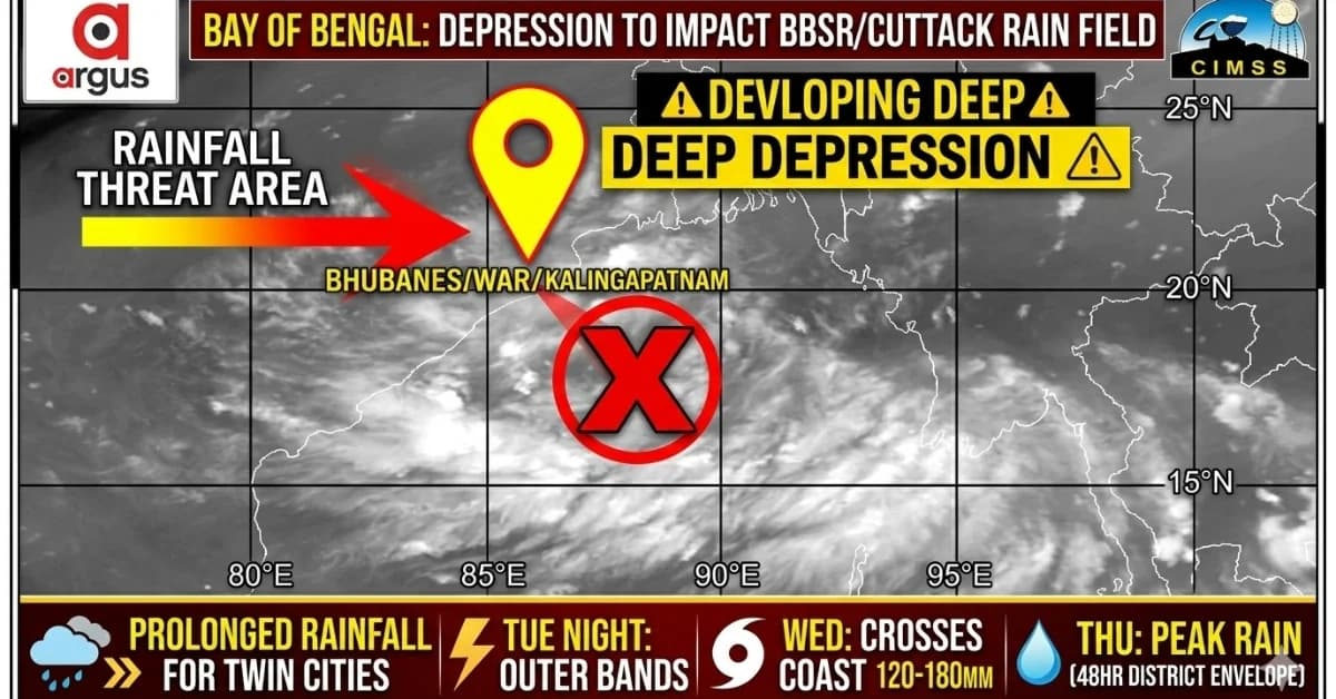
Bhubaneswar: The developing Bay of Bengal deep depression may make landfall well south of the Odisha capital, but Bhubaneswar and Cuttack are unlikely to escape its rainfall shield.
The twin cities are positioned north of the likely Kalingapatnam landfall corridor. That keeps them away from the strongest landfall wind core, but not necessarily from the system's broader moisture field.
The present weather signals point towards the first noticeable depression-related showers reaching the twin-city region from Tuesday evening/night, September 22, followed by a much wetter Wednesday and the possibility of the most persistent rainfall on Thursday, September 24.
The CIMSS water-vapour analysis shows a broad moisture canopy extending north of the circulation, while the IMD warning sequence currently keeps Odisha under very heavy rain on September 22 and extremely heavy rainfall on September 23–24.

📱 Get Argus News App
✨Why Bhubaneswar and Cuttack can get heavy rain despite a southern landfall
The key is where the circulation goes versus where its moisture goes.
The emerging track assessment places the deep depression's core near Kalingapatnam/Srikakulam on Wednesday, followed by a west-northwestward inland movement towards Telangana.
That trajectory places Bhubaneswar and Cuttack on the northern side of the system's circulation and moisture envelope.
The CIMSS water-vapour interpretation shows the cloud and moisture shield extending well beyond the centre, including north of 20°N. The analysis consequently places the capital region under the active moisture canopy during September 23–24.
This is why the twin cities' threat is primarily rainfall and urban drainage, rather than direct 50-60 kmph like winds.
Twin-city rainfall timeline
|
Period |
|---|
Bhubaneswar-Cuttack weather
Expected rainfall
Wind
Likely impact
Tuesday, Sept 22 evening/night
Outer rainbands arrive; intermittent thunderstorms
Light/moderate initially, rapidly increasing
Gusty during thunderstorms
Sudden showers, lightning, early waterlogging in vulnerable pockets
Wednesday, Sept 23
Broad moisture shield overspreads region
Heavy to very heavy; persistent spells
Around 30–45 kmph, locally stronger gusts
Drainage congestion, traffic disruption, tree/branch damage
Thursday, Sept 24
Peak rainfall phase
Heavy to very heavy; local intense downpours
Squally, generally below landfall-core winds
Urban waterlogging, local flooding, power interruptions
Friday, Sept 25
Rain begins easing
Moderate, isolated heavy spells possible
Gradually weakening
Residual drainage and waterlogging problems
Sept 26 onward
System influence declines
Scattered/residual rain
Lower
Gradual recovery
The assessment estimates around 120–180 mm over Khordha and Cuttack districts within 48 hours, with the greatest concern arising from the duration and continuity of rainfall rather than a single short cloudburst.
Tuesday night: the warning arrives before the main rain
The first phase should not be interpreted as the peak event.
The initial outer bands are expected to move into the twin-city region from Tuesday evening into Tuesday night. The CIMSS moisture analysis specifically places the first capital-region impact in the late Tuesday-night period.
Expect:
Increasing cloud cover;
Intermittent rain;
Thunderstorms and lightning;
Short-duration intense showers;
Gusty winds during thunderstorms.
The rainfall may initially appear episodic, but the larger moisture plume will already be established.
Wednesday: the twin cities move into the active rain shield
Wednesday becomes the transition from peripheral influence to widespread weather.
As the depression approaches and crosses the north Andhra coast, its circulation will pull a large quantity of moisture inland. The twin cities, although north of the centre, will be positioned beneath the northern part of that moisture envelope.
This can produce repeated rainbands rather than one isolated spell.
The difference matters.
A short, intense shower can overwhelm drains temporarily. But several rain episodes over 12–24 hours progressively saturate the ground, reduce drainage efficiency and increase the probability of persistent waterlogging.
Thursday: likely peak urban rainfall stress
Thursday is the day that deserves the greatest attention in the twin-city forecast.
The depression by then would be inland and moving towards Telangana. But the system does not lose its moisture immediately after landfall.
Instead, its circulation continues to transport moisture into Odisha while the system moves west-northwest.
The assessment therefore places September 24 as the peak rainfall period for Bhubaneswar and Cuttack, with a projected 120–180 mm combined district-scale rainfall envelope over 48 hours.
This is not a prediction that every location in either city will receive 120–180 mm. It is a district-scale/area-envelope estimate, and rainfall will be highly uneven because individual rainbands can produce substantially different totals over short distances.
Wind: rain threat is bigger than wind threat
The twin cities should not be treated as a direct landfall wind zone.
The assessment estimates sustained/squally winds of roughly 30–45 kmph, with stronger short-lived gusts possible during thunderstorms.
That is substantially different from the strongest coastal Andhra impact, where the analysis places squalls around 50–60 kmph with gusts up to 70 kmph near the core.
For Bhubaneswar and Cuttack, therefore, the principal urban risks are:
rainfall → drainage overload → waterlogging → traffic disruption → localised power interruptions.
Where the impact could become visible first
Bhubaneswar
The most vulnerable locations will be areas where intense rain coincides with:
already saturated ground;
low-lying roads;
drainage bottlenecks;
construction zones;
underpasses and depressed road sections.
Strong thunderstorm gusts could also break weak branches and create isolated power-line problems.
Cuttack
Cuttack's exposure is somewhat different because of its dense built environment and drainage constraints.
Persistent rain over several successive spells can create waterlogging even without exceptionally violent winds.
The concern is therefore less about structural wind damage and more about the cumulative effect of rainfall.
Why the rain may continue after the landfall
This is the most important meteorological distinction.
Landfall is the movement of the circulation centre across the coast. It is not the disappearance of the moisture field.
The CIMSS analysis shows the system embedded in a broad moisture environment, while the mid-level steering winds carry the circulation inland towards the Telangana sector.
Consequently, Wednesday's landfall near Kalingapatnam could actually coincide with increasing rainfall over Bhubaneswar-Cuttack, rather than marking the end of their weather threat.
By Thursday, the inland depression's circulation and associated moisture transport could keep the twin cities under persistent rain even though the centre itself is hundreds of kilometres away.
The likely 48-hour urban weather window
The current analytical window can therefore be summarised as:
Tuesday
evening/night, Sept 22:
First
outer bands and thunderstorms.
Wednesday,
Sept 23:
Widespread
rain; intensity increases as the system crosses Andhra and moves
inland.
Thursday,
Sept 24:
Likely
peak rainfall and maximum urban drainage stress.
Friday,
Sept 25:
Rain
gradually decreases, but residual showers and waterlogging can
persist.
The IMD's current Odisha warning itself supports a prolonged rather than one-day event: very heavy rain on September 22, extremely heavy rainfall on September 23–24 and very heavy rain on September 25.
Bottom line
The twin cities' weather threat is therefore not a direct landfall threat but a prolonged moisture-tail event.
If the deep depression follows the currently indicated Kalingapatnam–Telangana corridor, Bhubaneswar and Cuttack could remain north of the strongest wind field while still receiving substantial rainfall.
The period to watch most closely is Tuesday night through Thursday, with Thursday (till evening) emerging as the likely peak urban-rainfall day.
The
principal concern is consequently not destructive landfall winds but
120–180
mm of potentially uneven rainfall over roughly 48 hours, repeated
heavy downpours, drainage overload and consequent urban waterlogging,
with local thunderstorm gusts adding a secondary risk.
Also Read: EXCLUSIVE | Deep Depression Track Update: Kalingapatnam Emerging as Landfall Zone; When, Where Will Odisha Feel the First Impact?
Related Topics
Explore more stories