



EXCLUSIVE| Deep Depression Big Impact: CWC Warns of Severe Flood Risk at Polavaram, Sabari in Andhra Pradesh; Will Odisha's Hirakud Open Gates Within 72 Hours?
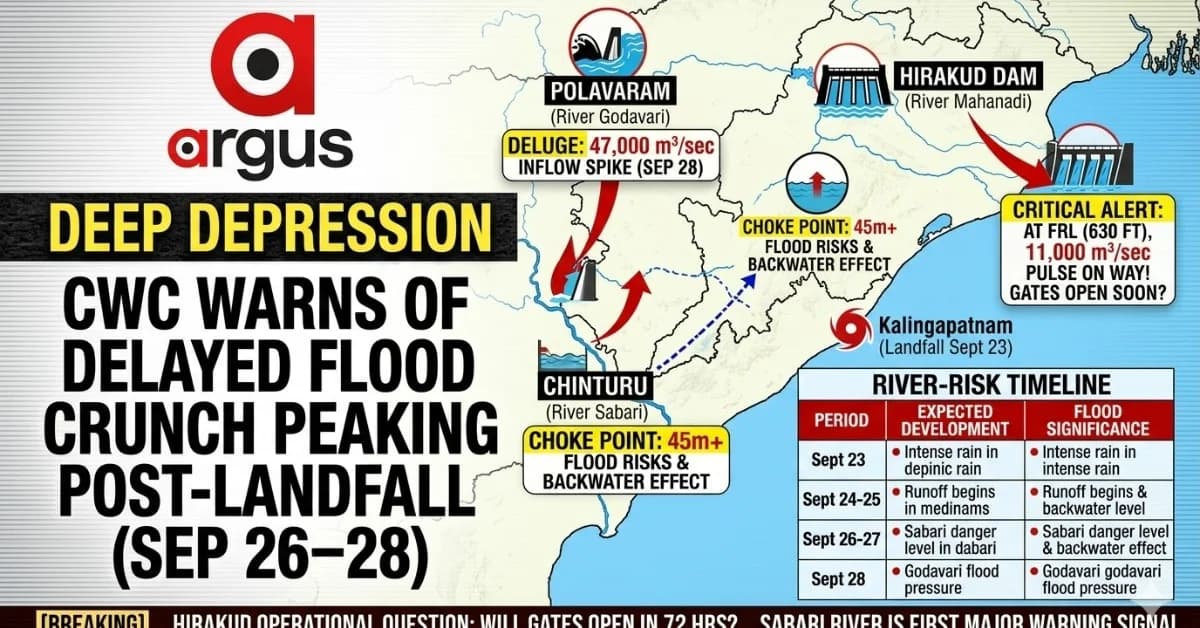
Key Points
Landfall vs. Hydrological Peak: The deep depression makes landfall near Kalingapatnam on September 23, but the actual flood threat peaks days later (September 26–28) as cumulative runoff travels downstream.
Godavari-Sabari Surge: Chinturu water levels on the Sabari river are projected to cross the 42-meter danger mark (reaching 45m+), followed by an extraordinary 47,000 m³/sec inflow at Polavaram by September 28.
Hirakud Dam Management: With Hirakud currently at its Full Reservoir Level (FRL) of 630 feet and zero gates open, incoming upper-basin inflows projected to near 11,000 m³/sec may force controlled releases within 72 hours.
Bhubaneswar:The deep depression approaching the north Andhra Pradesh–south Odisha coast may make landfall around Kalingapatnam on Wednesday morning, September 23, but the bigger hydrological threat could emerge days after landfall.
River and reservoir projections point to a delayed surge across the Godavari-Sabari system, with Chinturu potentially rising beyond its 42-metre danger level towards 45 metres or more, while inflow into the Indirasagar/Polavaram system could climb to an extraordinary 47,000 cubic metres per second around September 28.
That creates a widening flood-risk window from September 26 to 28, even as the weather system itself weakens after moving inland.
For Odisha, the critical question is now whether the delayed runoff from the upper Mahanadi basin will force Hirakud Dam to begin controlled releases within the next 72 hours.

📱 Get Argus News App
✨The reservoir projections made by CWC show Hirakud inflow rising sharply from around 1,000 cubic metres per second to nearly 11,000 cubic metres per second by Day 7 (Sept 28). The reservoir is also reported to be at its 630-foot Full Reservoir Level, with no sluice gates currently open.
The flood threat may peak after landfall
The important distinction this time is between the meteorological peak and the hydrological peak.
The deep depression is expected to reach the north Andhra-south Odisha coast around September 23. Its immediate impact will be concentrated around the coastal and adjoining interior catchments.
But river systems respond more slowly.
The Sabari, flowing through the Eastern Ghats and along the Odisha-Chhattisgarh-northern Andhra region before joining the Godavari, can respond rapidly because of its steep mountainous catchments. The available projection indicates the Chinturu level could breach the 42-metre danger mark around September 26–27.
The Godavari response is expected to come later.
Its enormous multi-state catchment means rainfall received during September 23–24 can continue moving downstream for several days. The projection therefore places the major Polavaram inflow surge around September 28.
River-risk timeline
|
Period |
Expected development |
Flood significance |
|---|---|---|
|
Sept 23 |
Deep depression approaches/makes landfall near Kalingapatnam |
Intense rainfall over coastal and adjoining catchments |
|
Sept 24–25 |
Runoff begins accumulating across upstream catchments |
Reservoir and river inflows start responding |
|
Sept 26–27 |
Chinturu/Sabari projected to cross danger level |
Severe local flood threat |
|
Sept 28 |
Polavaram inflow projected near 47,000 m³/sec |
Major lower-Godavari flood pressure |
|
Next 72–96 hrs |
Hirakud inflow projected to rise sharply |
Potential requirement for reservoir-management intervention |
Sabari could become the first major warning signal
The projected Sabari response is important because it could precede the main Godavari surge.
The Sabari's catchment is relatively steep and mountainous. Heavy rainfall associated with the depression can therefore be converted into rapid runoff, producing a sharp rise at Chinturu.
The available projection puts the Chinturu level above the 42-metre danger level, potentially reaching 45 metres or more.
But the problem does not necessarily end with the local Sabari rise.
Once the Godavari itself swells significantly downstream, drainage from tributaries can become increasingly difficult. The analysis describes this as a potential backwater effect, with the swollen Godavari restricting the normal discharge of the Sabari near their confluence.
That is why the Chinturu and Polavaram numbers need to be read together rather than independently.
Polavaram: the bigger delayed surge
The most striking number in the projections is the 47,000 m³/sec inflow forecast for the Indirasagar/Polavaram system around September 28.
That would come several days after the expected landfall.
The reason is the enormous size of the Godavari drainage network. Rainfall does not translate immediately into downstream reservoir inflow. Water from different parts of the catchment reaches the lower river at different times, creating a cumulative surge.
This creates a potentially dangerous sequence:
Landfall → intense catchment rainfall → rapid Sabari response → rising Godavari → reduced tributary drainage → delayed Polavaram inflow surge.
The available projections therefore suggest that September 26–28 could become more hydrologically important than the actual September 23 landfall day.
The Hirakud question: will gates have to open?
This is where Odisha's risk assessment becomes particularly important.
The available reservoir figures show Hirakud at 630 feet, its FRL, with zero sluice gates open. At the same time, projected inflows are shown rising from around 1,000 m³/sec initially to approximately 11,000 m³/sec by Day 7 (Sept 28).
That combination leaves very little room for complacency.
The key issue for dam managers is not today's inflow alone. It is how much storage cushion exists before the delayed upper-catchment runoff arrives.
If the projected 11,000 m³/sec inflow materialises, maintaining the reservoir at FRL would leave operators with substantially less flexibility to absorb the incoming water.
An analysis, therefore, anticipates controlled, phased gate operations as the upper-basin runoff approaches.
However, as of now, Hirakud authorities didn't respond to the question whether an official 72-hour gate-opening on schedule.
So the headline question –Will Hirakud open its gates within 72 hours? – should be presented as an emerging operational question, not a confirmed decision.
Hirakud is not the only reservoir to watch
The hydrological response across Odisha is not uniform.
At Balimela, the projected pattern is different. The reservoir is reported to be around 1,482 feet against an FRL of 1,516 feet, leaving more than 30 feet of vertical storage cushion. Its storage is estimated at around 58%, while inflow is projected to show a double peak, reaching approximately 1,100 m³/sec around Day 6.
That gives Balimela substantially more immediate storage flexibility than Hirakud.
Rengali presents another pattern. Its inflow is projected to rise more gradually, from around 750 m³/sec to 1,500 m³/sec by Day 6, reflecting the broader and more distributed rainfall response across its catchment.
Reservoir pressure comparison
|
Reservoir/system |
Present position in supplied inputs |
Projected inflow/response |
Immediate concern |
|---|---|---|---|
|
Hirakud |
630 ft / FRL; 0 gates open |
~11,000 m³/sec by Day 7 |
Storage cushion and gate management |
|
Balimela |
~1,482 ft vs 1,516 ft FRL; ~58% storage |
~1,100 m³/sec |
Considerable storage cushion |
|
Rengali |
Gradual inflow rise |
~1,500 m³/sec by Day 6 |
Sustained Brahmani pressure |
|
Chinturu/Sabari |
Danger level 42 m |
Potentially 45 m+ |
Severe river flooding risk |
|
Polavaram/Godavari |
Downstream response delayed |
~47,000 m³/sec by Day 7 |
Major lower-Godavari flood pressure |
Why the next 72 hours matter
The immediate focus will understandably remain on the deep depression, rainfall and landfall.
But the reservoir and river data suggest a second phase of the event is developing.
The first phase is meteorological – the depression crossing the coast.
The second is hydrological – water accumulated over multiple catchments travelling downstream after the system has already moved inland.
That lag is precisely why a weakening weather system does not automatically mean a weakening flood threat.
For Hirakud, the next 72 hours could therefore be decisive from a reservoir-management perspective. If substantial upper-basin runoff begins arriving while the reservoir remains at FRL, operators may have to create storage space through controlled releases.
But whether and when gates are opened will ultimately depend on actual inflows, reservoir level, downstream river conditions, rainfall over the catchment and official dam-management decisions, rather than the rainfall forecast alone.
The real threat: a delayed flood pulse
The emerging picture is therefore more complex than a simple “deep depression = heavy rain” story.
The system is expected to make landfall around Kalingapatnam on September 23. Yet the available hydrological projections point towards a delayed flood pulse, moving through the river network after the weather system has already crossed the coast.
The first major warning could come from the Sabari-Chinturu corridor around September 26–27.
The larger downstream surge could follow at Polavaram around September 28, with the projected inflow touching 47,000 m³/sec.
And in Odisha, the critical watchpoint is Hirakud, where the reservoir is reported at FRL even as projected inflows rise sharply.
The
next three days, therefore, are less about where the depression will
be and increasingly about where
the water generated by it will be three to five days later.
Also Read: EXCLUSIVE | Deep Depression Track Update: Kalingapatnam Emerging as Landfall Zone; When, Where Will Odisha Feel the First Impact
Related Topics
Explore more stories