



Another Bay System Brewing? Models Signal Active Monsoon to Return With Fresh Rain Spell Over Odisha From July 12-15 | Exclusive
Key Points
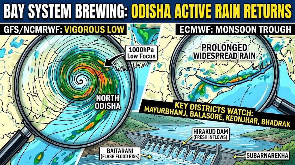
Model Divergence: IMD, NCEP GFS and NCMRWF predict a well-defined low-pressure area (1000 hPa) tracking near the Odisha-WB border, while ECMWF foresees a broad, active monsoon trough.
Primary Target: Northern Odisha districts-including Mayurbhanj, Balasore, Bhadrak, Keonjhar, and Jajpur-face the highest risk of intense rainfall and rapid water level rises in the Baitarani and Budhabalanga systems.
Basin Outlook: Steady rainfall over western Odisha will continue to replenish inflows into the Hirakud Reservoir, while downstream urban centers face localized waterlogging rather than severe riverine flooding.
Bhubaneswar: After a brief easing of widespread rainfall over Odisha, weather models are increasingly pointing towards another active phase of the southwest monsoon beginning around July 12, with rainfall intensifying across much of the state by July 14.
While there remains disagreement over the exact strength of the system, there is growing consensus that the northwest Bay of Bengal will once again become the focal point of monsoon activity, ensuring widespread rain across Odisha.
The latest suite of global and regional numerical weather prediction models presents two different scenarios. However, both lead to the same practical outcome for Odisha: another wet spell.
Three Models See a Fresh Low Pressure Area

📱 Get Argus News App
✨The more aggressive guidance comes from the IMD-GFS, NCMRWF and NCEP-GFS deterministic model, all of which develop a well-defined cyclonic circulation or low-pressure area over the northwest Bay of Bengal between July 13 and July 15.
The NCEP GFS solution is particularly robust.
It develops a closed 1000 hPa low-pressure centre just off the Odisha-West Bengal coast before moving inland. The accompanying rainfall field depicts a concentrated core of heavy precipitation extending across northern coastal Odisha into Gangetic West Bengal.
The NCMRWF wind forecasts strengthen this signal further.
Its forecast depicts a well-organised cyclonic vortex over the northwest Bay, with strong southwesterly moisture transport from the Arabian Sea converging into Odisha. The circulation tracks close to the Odisha-West Bengal border – an evolution historically associated with widespread heavy monsoon rainfall across northern and central Odisha.
The accompanying wind fields show a vigorous low-level jet feeding enormous quantities of moisture into eastern India, suggesting favourable conditions for sustained convective activity.
ECMWF Takes a More Conservative View
The European Centre for Medium-Range Weather Forecasts (ECMWF) paints a less dramatic picture.
Instead of forming an independent low-pressure system, the model maintains an active monsoon trough stretching across northern India into the northwest Bay of Bengal.
Under this scenario, Odisha still receives widespread rainfall, but the precipitation is distributed more uniformly rather than concentrated around a deep cyclonic core.
In other words, the ECMWF supports an active monsoon rather than a vigorous low-pressure event.
Consensus Still Favors Wet Conditions
Despite differences in intensity, there is one notable agreement across all major models.
The southwest monsoon is expected to remain active over Odisha between July 12 and July 15.
The disagreement lies only in whether rainfall arrives as:
- a classic Bay low-pressure system producing intense localized downpours (GFSs, NCMRWF), or
- an active monsoon trough producing prolonged widespread rainfall (ECMWF).
From an impact perspective, both scenarios support another significant rainfall episode.
Northern Odisha Emerges As Primary Target
Should the GFS-NCMRWF solution verify, northern Odisha would likely receive the heaviest rainfall.
Districts expected to remain under close watch include:
- Mayurbhanj
- Balasore
- Bhadrak
- Keonjhar
- Jajpur
These districts lie along the northern flank of the projected cyclonic circulation where deep moisture convergence is strongest.
Heavy rainfall over the Similipal hills and Keonjhar catchments could produce rapid rises in the Baitarani, Budhabalanga and Subarnarekha river systems, with localized flash flooding becoming possible in vulnerable low-lying areas.
Even under the weaker ECMWF scenario, northern Odisha remains closest to the active monsoon trough, making it the most likely region to experience above-normal rainfall.
Mahanadi Basin Likely To Receive Fresh Inflows
The forecast also looks encouraging for the Mahanadi basin, especially the upper catchments spread across western Odisha and adjoining Chhattisgarh.
Strong monsoon flow indicated by multiple models is expected to generate steady rainfall over:
- Jharsuguda
- Sambalpur
- Bargarh
- Sonepur
- Boudh
- Angul
Such rainfall would continue replenishing inflows into Hirakud Reservoir, maintaining healthy storage during the core monsoon season.
Further downstream, districts including Cuttack, Bhubaneswar, Khordha, Jagatsinghpur, Kendrapara and Puri may experience a spell of heavy rain if the Bay low strengthens as projected by GFS.
However, the present indications do not suggest a major riverine flood event comparable to severe monsoon years.
Instead, localized urban flooding, waterlogging and drainage congestion may become the primary concern.
Brahmani Basin Also Under Watch
The Brahmani basin is another area likely to respond significantly.
Strong moisture convergence projected over Sundargarh, Deogarh and Angul could enhance rainfall across the Rengali reservoir catchment, leading to higher river discharge downstream.
Parts of Jajpur and Kendrapara, where the Brahmani and Baitarani river systems interact, may require close monitoring if the stronger model solutions materialize.
Southern Odisha To Receive Sustained Monsoon Rain
Unlike the north, southern Odisha is unlikely to lie directly beneath the centre of the projected circulation.
Instead, districts including:
- Ganjam
- Gajapati
- Rayagada
- Koraput
- Malkangiri
are expected to remain under a persistent southwesterly monsoon flow.
This setup favours moderate to heavy orographic rainfall along the Eastern Ghats rather than short-duration cloudbursts.
While widespread basin flooding appears less likely in southern Odisha, localized landslides cannot be ruled out in hilly terrain if rainfall persists for several days.
Confidence Increasing For Another Active Monsoon Phase
At nearly a week of lead time, forecast uncertainty naturally remains.
The exact position and intensity of any Bay low-pressure area will determine whether Odisha experiences widespread moderate rain or pockets of very heavy rainfall.
Nevertheless, with GFS, NCMRWF and another deterministic model converging on the development of a northwest Bay low-pressure system – and ECMWF independently maintaining an active monsoon trough – the probability of another wet spell has increased considerably.
For Odisha, the message is becoming clearer.
The brief lull in rainfall is unlikely to last long.
From July 12 onward, the southwest monsoon appears set to regain strength, with July 13-15 emerging as the most favourable window for widespread rainfall across the state, and July 14 currently looking like the peak day for many districts if the stronger Bay system evolves as projected.
Either way,
Odisha is likely to remain under an active monsoon regime through the middle of
next week.
Also Read: From July 6, 16–32 mm Daily Rainfall to Lash Odisha’s Mayurbhanj to Bhubaneswar; Baitarani-Budhabalanga Basin Under Watch| Exclusive
Related Topics
Explore more stories