Monsoon 2026 Forecast / Odisha to Witness Intense Thunderstorms after May 26; Monsoon Kerala Onset Delays, Early Onset over Northeastern States|Exclusive
Key Points
Bhubaneswar: BIG atmospheric configurations to fore. The latest IMD-GFS and NCMRWF model projections predict big. Kerala Monsoon onset seems delayed. Early onset over northeastern states seems possible.
While the IMD’s Monsoon update shows southwest monsoon progressing vigorously over the bay, the onset has been declared over more parts of southeast Arabian Sea and some parts of Comorin area.
However, a glance at the IMD-GFS and NCMWRF model projections brings alive startling conclusions. At the heart of this evolving pattern lies the cross-equatorial current —the engine room of the southwest monsoon. And right now, it is sending mixed signals.
Phase 1: May 22 — A hesitant push
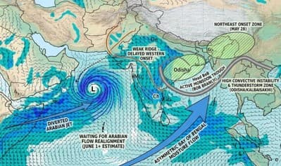
By May 22, the model clearly shows a present but subdued cross-equatorial flow over the Arabian Sea. This is critical. The monsoon’s traditional onset over Kerala depends heavily on the strength and depth of this surge.
Instead, what emerges is a structural distortion. The flow arches into a ridge over western India—a sign of subsidence and atmospheric stability.
Simultaneously, a trough develops over Andhra Pradesh–Tamil Nadu, indicating localized instability.
Interpretation:
This is not a classic onset signature. The Arabian Sea branch—crucial for Kerala—is active, but not decisive. The ridge formation over western India effectively blunts the inland penetration of moisture.
Phase 2: May 26 — Momentum builds, but shifts east
The projections show robust, sustained cross-equatorial south-westerlies originating from the Horn of Africa, curving across the equatorial Indian Ocean. By May 27, the wind vector density intensify significantly right over the equator and stretch cleanly into the Bay of Bengal (BoB).
The streamline configuration over the BoB shows a deep, aligned south-westerly to southerly surge heading straight toward the Northeast states and Bangladesh. The low-level jet is well-defined.
Given the vigorous BoB branch shoving deep moisture directly into the northeastern topography by May 27, an onset or massive ramp-up in precipitation over Northeast India around May 28 fits the dynamic layout perfectly.
Kerala Onset: A Delayed or Diffused Trigger?
📱 Get Argus News App
✨The latest model runs clearly indicates Kerala onset uncertain before June 1. While the cross-equatorial flow is strengthening over the Arabian Sea, it lacks a tightly organized, concentrated low-level westerly jet slammed directly against the southwest coast of India on these dates. The flows are broad and somewhat divergent over the central Arabian Sea, suggesting that the core, criteria-meeting Kerala onset will likely hold off until around June 1 or shortly after.
The most striking feature of IMD GFS run is likely formation of a distinct cyclonic circulation over the western/central Arabian Sea.
This system is acting as a massive atmospheric pump, organizing a very strong, concentrated low-level jet directly from the Horn of Africa.
However, because this circulation is sitting so far west, it is monopolizing the Arabian Sea's cross-equatorial flow, pulling the bulk of the high-velocity winds toward the Arabian Peninsula/Socotra region rather than letting them slam into the southwest coast of India.
This perfectly explains why the Kerala onset looks soft or delayed before June 1: the main westerly energy is being diverted away from the Indian mainland.
Why Monsoon Early Onset Over North-Eastern States
The model reading shows despite the western diversion, the air masses curve sharply over the equator and launch an incredibly broad, continuous corridor of strong south-westerlies straight into the Andaman Sea and the entire Bay of Bengal.
Odisha Impact
A look at the IMD model runs shows a highly organized, direct southerly to south-southeasterly moisture injection penetrating deep into Odisha, West Bengal, and Bangladesh.
Weather charts of IMD and NCMRWF shows the likely formation of an anticyclonic ridge, leading to a drier atmosphere over the western arm of Indian landmass. Whereas over the head BoB and the eastern states, the winds curve cyclonically into a clear zone of lower geopotential height. The contour dips low over the northern BoB and West Bengal/Odisha by May 27, creating a trough like orientation over the eastern side.
· Heatwave Termination: Weather charts show the continental north-westerlies over Odisha are completely blocked and replaced by this deep marine southerly surge. The heatwave will break structurally by May 26, replaced by a highly volatile, moisture-laden atmosphere. While daytime temperatures will drop below the severe heatwave thresholds, the high humidity will transition the weather from dry, searing heat to oppressive, sultry, and humid conditions.
· Severe Thunderstorms in Odisha, West Bengal: The trough pattern over eastern India, paired with strong moisture feed from the vigorous BoB branch at lower atmosphere creates an ideal environment for moisture convergence, lower-level instability, and widespread convective activity. So Odisha, West Bengal will witness severe convection
The Verdict
The latest model runs by India’s two top weather forecasters – IMD and NCMRWF – suggest a clear split mosnoon signal. The monsoon will likely exhibit a two-speed advance. It will charge into Northeast India swiftly by the end of May. However, its arrival over Kerala will be more measured (flirting with the normal June 1 timeline).
For Odisha,
this means the initial moisture and pre-monsoon showers will come early via the
Bay's high-octane performance, but the official structural declaration of the
monsoon's arrival over the state may not be accelerated, likely tracking closer
to its standard second-week-of-June timeline.
Also Read: Early Monsoon Exclusive / Beyond the Cyclone Scare: How a Brewing Bay System is Secretly Fast-Tracking the 2026 Monsoon onset over Keralam, Andaman
Related Topics
Explore more stories