



Odisha @2036: Future Tense; Urban Flooding in Bhubaneswar, Puri, Cuttack to Rise Exponentially| Exclusive
Key Points
Bhubaneswar: A silent structural crisis unfolding along Odisha’s coastline could dramatically worsen the State’s urban flooding problem by the time Odisha celebrates its centenary in 2036.
Data tabled by the Ministry of Ports, Shipping and Waterways in the Rajya Sabha on Tuesday paints a striking picture of a coastline in flux.
Of the 564.14 km of Odisha coastline analysed by the National Centre for Coastal Research (NCCR), as much as 54.1% is witnessing accretion, or sediment build-up, while 28.3% is undergoing erosion. Only 17.6% has remained stable.
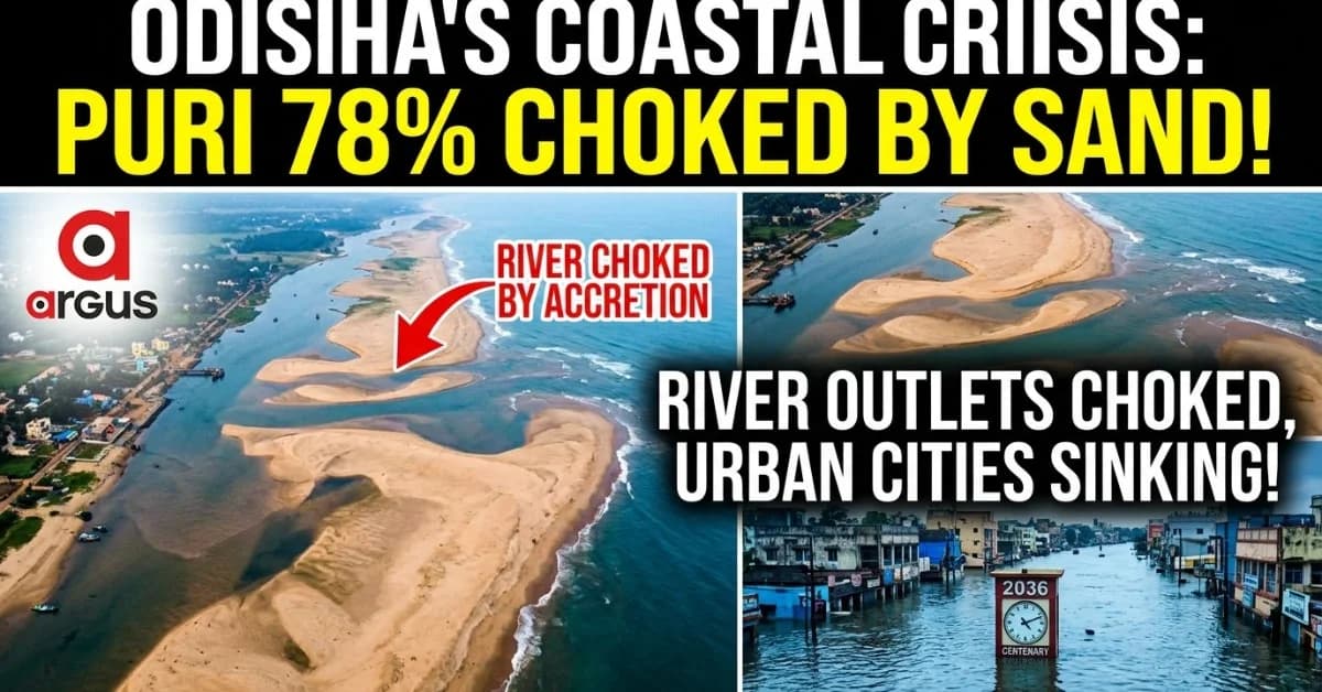
The most striking number comes from Puri, where 78.3% of the coastline is experiencing accretion. Bhadrak follows with 75.8%.

📱 Get Argus News App
✨At first glance, accretion may appear less alarming than coastal erosion.
But for a deltaic State criss-crossed by rivers and distributaries, excessive sediment deposition at river mouths and sea inlets can become a drainage problem. When heavy monsoon inflows meet a constricted downstream outlet, the consequence can be prolonged waterlogging, elevated river levels and backwater flooding.
That is where the coastal story begins to intersect with the urban story.
For Puri, Bhubaneswar and Cuttack, the warning is particularly significant. These cities do not operate as isolated hydrological islands. Their drainage and river systems are interconnected with the larger Mahanadi delta and the coastal discharge network. If downstream outlets progressively lose hydraulic efficiency while extreme rainfall and upstream river inflows intensify, the margin for safely evacuating floodwater becomes progressively narrower.
Coastline in Flux: Accretion Dominates, But Erosion Runs Deep
The NCCR assessment reveals that Odisha's coastline is undergoing two seemingly contradictory processes at the same time.
Across the State, 54.1% of the analysed coastline is accreting, meaning sediment is accumulating, while 28.3% is eroding. The remaining 17.6% is classified as stable.
But the district-wise numbers reveal how unevenly the crisis is unfolding.
Puri has the highest accretion share at 78.3%, followed by Bhadrak at 75.8%. Baleshwar records 54.0% accretion, while Jagatsinghpur has 39.0%, Kendrapara 38.1% and Ganjam 26.6%.
On the erosion front, the picture is almost the reverse.
Jagatsinghpur has 47.6% of its 55.80-km coastline under erosion, followed by Ganjam at 45.7% of its 60.18-km coastline and Kendrapara at 45% of its 149.36-km coastline. Baleshwar has 23.8% erosion, Puri 10.2% and Bhadrak 4.6%.
The message is therefore not simply that Odisha is losing its coastline.
It is that the coastline is being rearranged – with sand disappearing from some stretches and accumulating heavily elsewhere.
And that rearrangement has consequences for rivers, estuaries, wetlands, agriculture, fisheries and, increasingly, urban drainage.
Why Puri Matters to Bhubaneswar and Cuttack
Puri's 78.3% accretion figure assumes particular significance because several of the vulnerable stretches identified by the NCCR lie around critical interfaces between rivers, lagoons and the sea.
The report identifies either side of the Chilika Sea Mouth, Keutajanga, the Devi River mouth and the area south of the Devi mouth among vulnerable stretches.
NOTE: Devi River handles roughly 36% of peak river flow discharge from Mahanadi river system.
The Devi outlet is particularly important from a flood-management perspective.
A river can discharge only as efficiently as its downstream outlet permits. Heavy sediment accumulation around an estuary can alter its geometry, shift channels and create shallow sandbars. That does not mean every episode of accretion will automatically cause an urban flood. But when such a constrained outlet coincides with very heavy rainfall, high upstream discharge and high tidal levels, the drainage system can lose its ability to rapidly evacuate water.
That is the point at which a coastal geomorphology problem can become an urban disaster-management problem.
Puri: First in the Line of Fire
Puri is likely to feel the most direct consequences of any deterioration in the efficiency of coastal outlets.
Heavy monsoon rainfall over the Puri region, combined with substantial river inflows, can push water towards already stressed low-lying areas. If downstream discharge is impeded by changing estuarine geometry or sedimentation, water levels can remain elevated for longer.
The danger, therefore, is not merely more water, but water staying for longer.
That distinction could become critical in a future of increasingly intense rainfall events.
Bhubaneswar: The Urban Drainage Trap
Bhubaneswar is not located directly on the sea and is geographically higher than several coastal lowlands. Yet that does not make it immune to the coastal problem.
The city’s stormwater ultimately enters the broader drainage network through natural channels and river systems. Its urban expansion has also increased the volume and speed at which rainwater runs off impervious surfaces.
If downstream systems become increasingly congested, the urban drainage network can lose its ability to empty rapidly.
The result could be a familiar Bhubaneswar problem – waterlogging after intense rain – becoming a longer-duration and more severe phenomenon.
The city would, in effect, face a drainage paradox: rainwater is being generated rapidly inside the city while the larger downstream system is becoming progressively less capable of receiving and carrying it away.
Cuttack: The Deltaic Vulnerability
Cuttack presents an even more complex challenge because it sits within the Mahanadi delta between major river channels.
During periods of high discharge, river levels around the city can remain elevated for extended periods. If downstream distributaries and outlets face reduced carrying capacity, the pressure on the deltaic system increases.
This becomes especially significant when heavy rainfall coincides with substantial upstream releases into the Mahanadi system.
Thus, a future flood in Cuttack may increasingly be determined not only by how much rain falls over the city, but by how much water is arriving from upstream and how efficiently the downstream delta can discharge it.
That is why the coastal accretion data should not be viewed merely as an environmental statistic.
It is also a potential urban-infrastructure warning.
The Erosion Front: Odisha's Other 2036 Problem
If accretion threatens drainage outlets, erosion presents the opposite danger – the physical disappearance of the coastal buffer itself.
The NCCR assessment identifies several vulnerable stretches across Odisha.
In Ganjam, the areas north of Gopalpur Port and from Mayurpada to Bhramarakudi have been identified as erosion-prone.
In Jagatsinghpur, vulnerable stretches include Kusupur to Sahadabedi and Sahadabedi to Jatadhartanda.
In Kendrapara, the identified stretches include Hetamundia, Hukitola, Pentha to Satbhaya and Satbhaya to Gahirmatha.
In Puri, the vulnerable areas include either side of the Chilika Sea Mouth, Keutajanga, the Devi River mouth and south of the Devi mouth.
The list extends to Amarnagar in Bhadrak, while in Baleshwar, Bagda, Chaumukh, Narayan Mohanty Padia and Bindhapadmapur-Talasari have been flagged.
These are not uniform threats. Some stretches are losing land while neighbouring areas are gaining sediment.
That makes coastal planning considerably harder.
Why the Future Tense? The 2036 Coastal Landscape Could Look Very Different
The year 2036 will mark 100 years of Odisha's Statehood.
If present coastal dynamics persist, the centenary coastline may look substantially different from today's map.
In Jagatsinghpur, the high erosion share means stretches around Kusupur, Sahadabedi and Jatadhartanda will remain under pressure. Continued shoreline retreat can expose agricultural land, aquaculture facilities and settlements to increasing saline-water intrusion.
In Kendrapara, the stakes are even higher because the coastal barrier interacts with the Bhitarkanika ecosystem and the Gahirmatha coastline. The Pentha-Satbhaya-Gahirmatha belt is particularly sensitive. Continued erosion of the outer sandy barrier could weaken one of the natural buffers protecting the interior delta from cyclonic waves and storm surges.
In Ganjam, erosion around the north of Gopalpur Port and Mayurpada-Bhramarakudi stretches highlights another dimension: intervention in one part of the coast can alter sediment movement elsewhere. Port-related structures, breakwaters and other hard infrastructure can change littoral sediment transport, potentially creating accretion in one location and erosion in another.
In Puri, the story is almost the mirror image. The overwhelming 78.3% accretion means the central concern is not disappearing beaches alone but the changing geometry of river mouths, sea inlets and sandbars. The Devi mouth and Chilika Sea Mouth will therefore remain critical locations for long-term flood and water-exchange management.
In Baleshwar, the combination of 54% accretion with 23.8% erosion points towards an unstable shoreline. The Chaumukh-Talasari belt could see continued shifts in beaches and intertidal areas, complicating tourism, settlement and aquaculture planning.
And in Bhadrak, where 75.8% of the coastline is accreting, sediment accumulation could increasingly interact with low-lying coastal drainage and estuarine systems.
The Urban Flood Equation: Rain + River + Coast
This is where Odisha's 2036 challenge becomes more complicated.
Urban flooding is often treated as a city-level problem – inadequate drains, encroachment, shrinking wetlands, concretisation and poor stormwater management.
All of these remain important.
But the coastal data suggests another layer to the equation:
Rainfall inside the city + upstream river discharge + downstream tidal conditions + coastal sediment dynamics.
When all four combine unfavourably, the consequences can be disproportionately large.
For Bhubaneswar, the problem could manifest as persistent stormwater congestion.
For Cuttack, it could mean greater pressure from elevated river levels and deltaic backflow.
For Puri, it could mean direct exposure to prolonged coastal and backwater flooding.
The word “exponential” should therefore be understood as a warning about the non-linear nature of the risk: a modest loss of drainage capacity does not necessarily produce a modest increase in flood impact when the system is simultaneously hit by extreme rainfall, high upstream discharge and adverse tidal conditions.
Bottom Line: Odisha's Centenary Test
The data tabled in Parliament is more than a coastline inventory.
It is a warning that Odisha's coastal geography is changing in two directions at once – 28.3% erosion and 54.1% accretion.
For the Majhi government, the task ahead is therefore not confined to protecting villages from the advancing sea or building more coastal infrastructure.
It must address the hydrological consequences of a changing coastline.
That means closely monitoring the Devi and other river mouths, mapping sediment movement, protecting natural wetlands and mangroves, integrating coastal-zone planning with urban drainage plans, and ensuring that port and coastal infrastructure does not aggravate sediment imbalance elsewhere.
If Odisha wants to celebrate its centenary in 2036 as a safer, more resilient and better-planned State, the work has to begin now.
Because the Odisha of 2036 will not be shaped only by the buildings, roads and cities it constructs.
It will also
be shaped by where its rivers can still find the sea.
Also Read: Mahanadi Flood: Odisha Braces for 5-Foot Inundation in Bhubaneswar, Jagatsinghpur & Puri Pockets Sunday-Monday| Exclusive
Related Topics
Explore more stories