



No Flood Risk in Odisha: Baitarani to Stay Below Danger Mark; Hirakud, Rengali Set to Store Massive Monsoon Inflows| Exclusive
Key Points
* CWC Forecast Shows Reservoirs Absorbing Flood Peaks Instead of Releasing Them
* Major reservoirs like Hirakud and Rengali are safely operating with closed gates, successfully capturing thousands of million cubic metres of peak runoff to replenish seasonal storage
Bhubaneswar: Odisha is unlikely to witness any major riverine flood despite the recent spell of intense monsoon rainfall, with the latest flood bulletin issued by the Department of Water Resources (DoWR) on July 6 and the Central Water Commission's (CWC) seven-day advisory forecasts painting an increasingly reassuring picture.
The depression that triggered widespread heavy rainfall over western and northern Odisha has already started moving northwestwards towards Jharkhand and north Chhattisgarh, significantly reducing the threat of prolonged rainfall over the state's river basins.
While the Baitarani river at Akhuapada briefly emerged as the most closely watched location, official forecasts indicate that the river is expected to crest below the danger level, avoiding large-scale inundation of downstream villages.
Even more significantly, Odisha's two largest reservoirs – Hirakud on the Mahanadi and Rengali on the Brahmani – are entering a phase of rapid storage accumulation, absorbing huge upstream inflows that otherwise could have translated into downstream flood pressure.

📱 Get Argus News App
✨Baitarani Nears Danger Mark, But Forecast Rules Out Flood
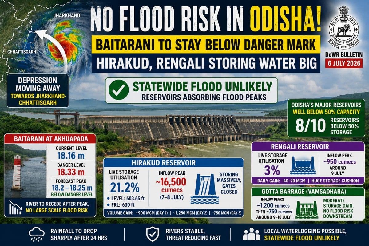
According to the DoWR Flood Bulletin issued on July 6, the Baitarani at Akhuapada recorded a water level of 18.16 metres, merely 17 centimetres below the danger level of 18.33 metres.
Ordinarily such a situation would trigger serious flood concerns. However, the CWC's short-range flood forecast suggests otherwise.
The seven-day hydrograph projects the river peaking at around 18.2-18.25 metres during the next 12 hours, remaining below the officially declared danger level.
After this brief crest, water levels are expected to begin a steady recession as rainfall rapidly diminishes across the catchment.
The hydrograph shows the river falling below the warning stage over the next few days before stabilising around 17 metres by the end of the forecast period.
This indicates that while low-lying areas may continue to experience localized waterlogging, large-scale riverine flooding downstream of Akhuapada is unlikely.
Mahanadi System Remains Well Within Safe Limits
The broader river system across Odisha remains comfortably below flood thresholds.
According to the DoWR bulletin:
- Khairmal on the Mahanadi stands at 103.81 metres, far below the danger level of 109 metres.
- Naraj is flowing at 22.79 metres, comfortably below its danger mark of 26.41 metres.
- Tikarpara continues to show a falling trend.
Similarly, rivers including the Brahmani, Subarnarekha, Budhabalanga and Rushikulya remain below danger levels despite recent rainfall.
This indicates that Odisha is facing a hydrologically favourable situation where runoff is increasing reservoir storage rather than generating downstream flood waves.
Depression Moving Away Reduces Flood Threat
The improving outlook is primarily driven by changing meteorological conditions.
The depression responsible for extremely heavy rainfall – including 328.4 mm at Sonepur and 276.6 mm at Telkoi – has already shifted towards Jharkhand and North Chhattisgarh.
The DoWR bulletin notes that although Orange Warning remains in force for parts of western Odisha on July 6, rainfall intensity is expected to reduce sharply thereafter.
By July 7, only Keonjhar and Mayurbhanj remain under Yellow Warning, while no widespread heavy rainfall has been forecast for the rest of the week.
The Quantitative Precipitation Forecast (QPF) further shows rainfall across all major river basins dropping to negligible levels from July 8 onwards, allowing rivers to gradually recede.
Hirakud Begins Massive Water Harvest
If the flood outlook is reassuring, the reservoir outlook is even more remarkable.
The CWC's advisory inflow forecast for Hirakud Reservoir shows one of the strongest monsoon replenishment events of the season.
Immediately after the forecast begins on July 6, inflows accelerate dramatically from below 3,000 cubic metres per second before surging to nearly 16,500 cubic metres per second between July 7 and July 8.
Yet this enormous inflow is not expected to create downstream flooding.
Instead, the reservoir is projected to absorb the entire flood pulse.
The accompanying volume forecast shows Hirakud storing approximately:
- 900 Million Cubic Metres (MCM) on Day 1,
- more than 1,250 MCM on Day 2,
- followed by another 750 MCM on Day 3.
This is possible because Hirakud entered the monsoon with substantial storage cushion.
According to the DoWR bulletin:
- Reservoir Level: 603.65 ft
- Full Reservoir Level (FRL): 630 ft
- Live Storage Utilisation: 21.2%
Despite receiving inflows exceeding 96,000 cusecs, the dam continues releasing only around 20,296 cusecs, with all spillway gates remaining closed.
In effect, the reservoir is functioning exactly as designed – capturing the flood peak rather than transmitting it downstream.
Rengali Offers Even Greater Flood Cushion
The situation is even more favourable in the Brahmani basin.
The CWC inflow advisory indicates Rengali Reservoir will witness a gradual increase in inflows, peaking near 950 cubic metres per second around July 9 before steadily declining.
The forecast shows daily storage gains of roughly 40-70 MCM, enabling the reservoir to harvest substantial monsoon runoff without operational stress.
What makes Rengali particularly important is its enormous unused storage capacity.
According to the DoWR bulletin, the reservoir is currently utilizing only about 3 per cent of its live storage capacity.
That effectively gives dam managers almost unrestricted room to impound incoming floodwaters from the upper Brahmani basin, substantially reducing downstream flood risk.
Vamsadhara Also Under Control
The CWC forecast for Gotta Barrage on the Vamsadhara depicts another well-regulated river system.
After witnessing an initial inflow peak of nearly 1,200 cubic metres per second, the barrage is expected to experience a second, much smaller pulse of about 750 cubic metres per second around July 9-10.
The daily storage volumes remain moderate, allowing the irrigation network to distribute water efficiently without generating flood conditions downstream.
Reservoirs Emerging as Odisha's Biggest Flood Buffer
The DoWR bulletin reveals another encouraging statistic.
Eight of Odisha's ten major reservoirs currently remain below 50 per cent of their storage capacity.
That means the state possesses enormous room to accommodate incoming runoff generated by the current monsoon spell.
Rather than forcing emergency spillway releases, reservoirs are effectively acting as giant flood buffers – capturing excess river flows and storing them for irrigation, drinking water and hydropower generation during the remainder of the season.
Outlook: Local Waterlogging Possible, Statewide Flood Unlikely
Taken together, the DoWR flood bulletin and the CWC's seven-day advisory hydrographs point towards a highly favourable hydrological scenario.
The atmosphere has delivered a short-duration burst of intense rainfall, but the weather system is now moving away. Rainfall is expected to weaken rapidly after the next 24 hours, river levels are projected to stabilise, and Odisha's major reservoirs are absorbing rather than releasing the flood peaks.
The only river requiring close monitoring remains the Baitarani at Akhuapada, where water levels may briefly rise close to the danger mark before beginning a sustained fall.
Unless there is an unexpected revival of heavy rainfall over the upper catchments, Odisha is unlikely to witness any major riverine flood during the coming week.
Instead,
this monsoon spell appears set to become one of the season's biggest reservoir
replenishment events, with Hirakud, Rengali and other major reservoirs
collectively storing thousands of million cubic metres of water while
simultaneously shielding downstream districts from flood risk.
Also Read: Rare WMO Warning: Will India, Odisha's July Rain Spell End Early? Strong El Niño May Overpower Even Positive IOD, Putting State's Monsoon at Risk| Exclusive
Related Topics
Explore more stories