



EXCLUSIVE | Odisha’s Great Land Scam: CAG Audit Exposes 12,393 Acres of Idle Industrial Land, Forest Encroachments, ₹597-Crore Public Asset Leak
Key Points
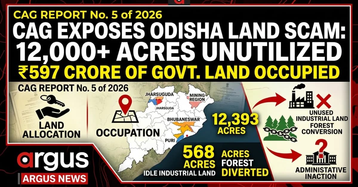
Unused Industrial Assets: Over 12,393 acres of industrial land remained unutilized for decades due to weak monitoring and lack of resumption actions.
Ecological Encroachments: Extensive unauthorized real estate development and land conversions were exposed in protected forests, wildlife sanctuaries, and eco-sensitive zones.
Significant Revenue Shortfall: The audit flagged massive financial leakages, including ₹148.46 crore in stamp duty evasion linked to the mining sector.
Bhubaneswar: Odisha’s land administration system is facing serious questions over the protection of public assets, with the Comptroller and Auditor General (CAG) Report No. 5 of 2026 (Civil) exposing extensive irregularities in industrial land allocation, unauthorized occupation of government property, conversion of protected forest and agricultural land, and violations of urban planning regulations.
The audit findings, as detailed in the report placed before the Odisha Legislative Assembly on Monday, point to a pattern of administrative inaction that allowed public land to remain locked under unused industrial allocations, private entities to occupy government property without proper authorization, and real estate development to extend into ecologically sensitive areas.
The scale of the findings is significant. Between 1981 and 2021, as much as 12,393.651 acres of industrial land remained unutilized for its intended purpose, while the absence of mandatory village-level land banks exposed 668.893 acres of government land valued at Rs597.87 crore to unauthorized occupation.
The audit also identified forest diversion without mandatory central approval, unauthorized industrial expansion, illegal subdivision of protected land, and substantial revenue losses from stamp duty evasion in the mining sector.

📱 Get Argus News App
✨The central issue emerging from the CAG findings is not merely the extent of land irregularities, but the failure of the state’s revenue administration to enforce existing laws, maintain accurate land records, monitor land use and recover public property where conditions of allotment were violated.
12,393 acres locked away: Four decades of industrial land allocation without recovery
The CAG’s findings point to prolonged failure to enforce conditions attached to government land allotments.
The most extensive finding in the audit concerns the state’s industrial land allocation policy, under which large tracts of public land were allotted to industries to facilitate investment and expand Odisha’s manufacturing base.
12,393.651 acres: Industrial land allocated between 1981 and 2021 that remained unutilized for its intended purpose.
Three to five years: The typical period within which companies were expected to initiate or execute projects under the conditions described in the audit material.
Decades of inaction: Revenue officials, including Tahasildars and District Collectors, failed to maintain mandatory progress reports and undertake adequate inspections of idle industrial land.
The conditions governing land allotment provide for resumption when companies fail to implement their proposed projects within the prescribed period. However, the CAG’s findings indicate that the machinery intended to recover unused land was not activated effectively.
This raises questions about the state’s ability to ensure that land allotted for industrial development is actually put to productive use. While land allocation is intended to facilitate investment, prolonged non-utilization without effective resumption action can prevent the government from reallocating valuable public resources to other eligible projects.
The audit also highlighted the absence of village-wise land banks mandated under Rule 42 of the Odisha Right to Fair Compensation and Transparency in Land Acquisition, Rehabilitation and Resettlement Rules, 2016.
These land banks were intended to establish a systematic record of public land and provide a reliable baseline for monitoring ownership, boundaries and occupation.
In their absence, the state lacked an important institutional mechanism to protect its land assets. The audit identified 668.893 acres of government land under unauthorized occupation, with an estimated value of Rs597.87 crore.
PUBLIC ASSET EXPOSURE
₹597.87 crore
Estimated value of 668.893 acres of government land identified as exposed to unauthorized occupation in the audit findings.
The significance of the finding extends beyond the monetary valuation. Without reliable land inventories, the government’s ability to identify encroachments, establish legal ownership and initiate recovery proceedings is weakened.
Jharsuguda: Industrial expansion on government land
The audit’s examination of industrial areas in Jharsuguda brings the enforcement gap into sharper focus. Cases involving NLC India Ltd. and Odisha Metallics Pvt. Ltd. illustrate how industrial expansion allegedly extended beyond authorized land boundaries.
NLC India Ltd. — Hirma village
20.950 acres
Government land identified under Khata No. 252, Plot No. 1801/4309, in Jharsuguda Tahsil.
Odisha Metallics Pvt. Ltd. — Marakuta village
Over 10 acres
Multiple government plots under Khata No. 282 reportedly occupied for industrial installations.
In Hirma village, the CAG identified 20.950 acres of public land within the industrial perimeter of NLC India Ltd. The audit material states that the land had been occupied without valid lease titles or completed government land-assignment clearances.
In Marakuta village, Odisha Metallics Pvt. Ltd. was found to have established industrial installations across more than 10 acres spread over 10 government plots.
The underlying issue identified by the audit is the failure of local revenue officials to cross-check physical industrial boundaries against cadastral maps and original land records. The report points to the absence of effective action under the Odisha Prevention of Land Encroachment Act, including eviction notices, penalties and recovery proceedings.
These cases raise a critical question about how industrial land boundaries are monitored after allotment and whether government departments are adequately coordinating to prevent unauthorized expansion.
Protected Forests and Wildlife Under Real Estate Pressure
The Comptroller and Auditor General (CAG) audit reveals alarming land-use violations in ecologically sensitive zones, protected forests, and wildlife sanctuaries, threatening public land ownership and local ecosystems.
Key Audit Findings
Unauthorized Occupancy: Land conversion and real estate development are actively encroaching on protected tracts.
Missing Clearances: Large acreage has been cleared and diverted for non-forest and commercial uses without mandatory central approvals.
Sub-division Risks: Sanctuary land is being partitioned into residential sub-plots.
Detailed Audit Breakdown
Sipasarubali, Puri
Land Identified: 97.18 acres
Audit Finding: DLC forest land recorded in private names
Adjacent DLC Tract, Puri
Land Identified: 7.24 acres
Audit Finding: Land cleared and developed without prior central forest clearance
Wildlife Sanctuary Area
Land Identified: 13.65 acres
Audit Finding: Divided into 156 residential sub-plots
Eco-Sensitive Zones (Puri & Khordha)
Land Identified: 41.65 acres
Audit Finding: Converted for commercial use
Forest Land (Sampled Areas)
Land Identified: 568.876 acres
Audit Finding: Diverted for non-forest purposes without central approval
The Sipasarubali findings are particularly significant because the audit identified 97.18 acres of District Level Committee (DLC) forest land recorded in private individuals’ names.
According to the audit details, parts of the area were subsequently cleared and developed for multi-storey apartments, hotels, spas and other commercial activities.
An adjacent 7.24-acre DLC forest tract was also found to have been cleared and built over without the required central government approval.
The audit further identified 13.65 acres within a wildlife sanctuary that had been divided into 156 residential plots and sold to private buyers.
Such transactions raise questions about land-registration scrutiny and compliance with wildlife protection requirements.
In Puri and Khordha, another 41.65 acres within notified Eco-Sensitive Zones were found to have been used for commercial purposes, despite restrictions under applicable notifications.
At the state level, 568.876 acres of forest land across sampled areas were reportedly diverted for non-forest purposes without central approval under the applicable forest conservation framework.
Taken together, these findings highlight a breakdown in coordination between revenue administration, land registration authorities, forest officials and planning agencies. They also raise questions about how protected land could be transferred, cleared or commercially developed without the necessary statutory safeguards.
Urban land conversion: 321 plots carved out to bypass layout approvals
The CAG’s examination of urban land use points to another dimension of the problem: the fragmentation of agricultural land into smaller residential plots, potentially allowing developers to avoid statutory layout approval requirements.
Across eight sampled urban Tahasils, the audit identified 21.882 acres of agricultural land within urban development boundaries that had been divided into 321 sub-plots.
The subdivision of land into smaller units can bring individual property transactions within the registration system while leaving the overall development without the required layout scrutiny under the Odisha Development Authorities Act, 1982.
The audit also identified:
504.768 acres of agricultural land converted for non-agricultural purposes across 24 sampled Tahasils.
31.124 acres in Bhubaneswar’s heritage and environmentally sensitive zoning areas affected by violations of Comprehensive Development Plan regulations.
10.085 acres of agricultural land converted into homestead plots across two sampled Tahasils, despite the absence of genuine approach roads or adequate civic access.
The 31.124-acre finding covers Bankuala, Dadha, Raghunathpur, Pandara and Sisupal villages. The audit identified land-use changes in areas designated for heritage conservation, agricultural buffers and environmentally sensitive development.
The wider concern is that land registration and land-use approval are separate regulatory processes. A registered transaction does not, by itself, establish that a particular development has complied with zoning, conversion or layout requirements.
The CAG findings point to weaknesses in the cross-verification of these processes, raising questions about the effectiveness of coordination between revenue offices and development authorities.
Mining sector: ₹148.46-crore stamp duty leakage
Major revenue finding
The audit’s financial findings extend beyond land occupation and unauthorized conversion to the assessment and collection of government revenue.
In Paragraph 3.11, the CAG identified Rs148.46 crore in stamp duty evasion associated with mining operations in Keonjhar and Jajpur.
The audit examined three major mines where production capacity had been increased. Such expansion can increase the economic value of mining leases and require supplementary lease agreements reflecting the revised terms and production capacity.
However, according to the audit material, supplementary agreements were either not executed or were processed using outdated baseline values.
The failure to integrate production-related information from the Steel and Mines Department with the land registration system meant that the revised lease values were not adequately reflected in the stamp duty assessment.
The resulting shortfall, quantified at Rs 148.46 crore, represents a significant revenue collection gap identified by the audit.
A separate finding in Paragraph 3.12 concerns the valuation of buildings during property registration. The CAG found that sub-registrars did not adequately follow the Revenue and Disaster Management Department’s Building Valuation Guidelines issued in May 2019.
Instead of independently verifying building characteristics, including construction materials, floor area and structural type, registration officials accepted inadequately verified declarations.
The audit identified Rs 27.42 lakh in revenue loss across the sampled transactions due to under-valuation.
These findings point to a broader weakness in the state’s revenue administration: the absence of effective verification systems to ensure that taxable transactions are assessed using accurate and updated information.
The land scam matrix: Where the audit identified failures
Selected findings from the CAG material supplied for this report. The figures cover different categories and may overlap; they should not be added together as a single estimate of land loss.
Sector-Wise Audit Findings & Administrative Gaps
Government Land for Industrial Purposes
Key Finding: 12,393.651 acres unutilized
Administrative Gap: Weak monitoring and resumption
Government Land
Key Finding: 668.893 acres valued at ₹597.87 crore
Administrative Gap: Absence of village land banks
Industrial Encroachment
Key Finding: 20.950 acres at Hirma; over 10 acres at Marakuta
Administrative Gap: Weak boundary verification and enforcement
Forest Diversion
Key Finding: 568.876 acres
Administrative Gap: Missing central approval
Agricultural Conversion
Key Finding: 504.768 acres
Administrative Gap: Weak conversion oversight
Urban Subdivision
Key Finding: 21.882 acres divided into 321 plots
Administrative Gap: Layout approval violations
Sanctuary Land
Key Finding: 13.65 acres divided into 156 plots
Administrative Gap: Failure of protected-area safeguards
Mining Stamp Duty
Key Finding: ₹148.46 crore
Administrative Gap: Failure to update lease valuation
Building Valuation
Key Finding: ₹27.42 lakh
Administrative Gap: Inadequate verification of declared structures
A failure of enforcement, not an absence of laws
The most consequential aspect of the CAG findings is that the irregularities identified were linked to existing laws and administrative procedures that were either not implemented or inadequately enforced.
The audit points to failures at several levels of government:
Revenue administration: Failure to maintain comprehensive land inventories, inspect unused industrial holdings and initiate timely recovery proceedings.
District and Tahsil authorities: Inadequate enforcement against unauthorized occupation and industrial boundary expansion.
Land registration offices: Failure to verify property valuations and ensure that transactions complied with applicable restrictions.
Planning authorities: Weak monitoring of land conversion, subdivision and layout approvals.
Forest and environmental administration: Gaps in protecting designated forest tracts, wildlife sanctuary areas and Eco-Sensitive Zones.
Interdepartmental coordination: Failure to adequately integrate mining production updates, lease valuations and registration records.
The findings suggest that the problem is not confined to isolated violations by individual landholders or developers. They expose weaknesses in the institutional systems designed to prevent public land from being diverted, occupied or commercially exploited without authorization.
The accountability question: Will the state recover its land and revenue?
The CAG’s findings place the focus on the next stage of the new government's action. Identifying irregularities through an audit is only the first step; the effectiveness of the state’s response will depend on whether the administration acts on the findings and implements corrective measures.
The key questions confronting the government include:
Land recovery: What action will be taken to recover government land occupied without authorization and to review industrial allotments that have remained unused for decades?
Forest protection: Will the administration initiate proceedings to restore illegally occupied or diverted forest land and examine the legality of existing developments in protected areas?
Revenue recovery: What steps will be taken to recover the identified stamp duty shortfall and improve the assessment of mining leases and registered properties?
Administrative accountability: Will the government establish responsibility for prolonged failures to inspect, report and enforce land-use regulations?
Institutional reform: Will village-wise land banks, digital cadastral records and interdepartmental verification mechanisms be established to prevent further unauthorized occupation and conversion?
THE CENTRAL ISSUE
Who was responsible for protecting Odisha’s public land, and why did the enforcement system fail?
The audit’s findings bring the functioning of the state’s land governance system under scrutiny. The next measure of accountability will be the government’s documented response, including recovery action, corrective measures and compliance with statutory requirements.
Conclusion: A land governance crisis with a substantial public cost
The CAG’s Report No. 5 of 2026 presents a wide-ranging account of weaknesses in Odisha’s management of public land.
From decades-old industrial allocations to unauthorized occupation in Jharsuguda, from forest land in Sipasarubali to urban zoning violations in Bhubaneswar, the audit identifies failures that cut across departments and jurisdictions.
The figures reveal the scale of the challenge: 12,393.651 acres of unused industrial land, 668.893 acres of government land exposed to unauthorized occupation, extensive forest and agricultural land-use violations, and Rs148.46 crore in identified stamp duty evasion in the mining sector.
These are distinct audit findings, not a single consolidated estimate of land or financial loss. Their significance lies in the common institutional concerns they raise: inadequate monitoring, weak enforcement, incomplete records and ineffective coordination among government agencies.
For Odisha, the challenge now is to translate audit observations into verifiable corrective action. The government’s response to the findings, the recovery of public assets where legally justified, and the strengthening of land administration will determine whether the weaknesses documented by the CAG lead to meaningful institutional reform.
The
central question is no longer simply how much public land has been
left unprotected, but whether the state’s enforcement machinery can
establish accountability and prevent the same failures from
recurring.
Also Read: SPECIAL REPORT | The Great GST Vanishing Act: CAG Exposes Odisha’s Tax Enforcement Failure, ₹1,165 Crore Revenue Loss
Related Topics
Explore more stories