



Odisha Flood Threat: Fresh Low Pressure on August 29 to Trigger Severe Multi-Basin Crisis, Know the Critical Districts| Exclusive
Key Points
Bhubaneswar: Odisha may be heading towards another dangerous flood phase just when several of its rivers are struggling to drain the impact of the present flood wave.
A fresh Low-Pressure Area is expected to form over the northwest Bay of Bengal by around August 29, potentially setting the stage for another spell of widespread heavy rainfall over an already saturated Odisha.
Apart from the IMD Extended Range Forecast, there has been a multi-modal consensus over the impeding low pressure area on around Aug 29.
The evolving weather pattern has been indicated by NCMRWF, IMD-GFS and ECMWF pointing towards another rainfall-bearing system around the August 29-30 window.

📱 Get Argus News App
✨Over the model consensus, the Central Water Commission’s flood forecast has already flagged renewed pressure on major river systems.
Already grappling with swollen rivers, high reservoir storage and saturated catchments, before letting the floodwaters fully recede, another low-pressure system over the northwest Bay may begin feeding fresh rainfall into the same river basins.
The Result: A compound flood situation in which new rainfall, reservoir inflows, dam releases and already swollen rivers converge simultaneously.
How The New Threat Pan Out
As the system develops and moves inland around August 29-30, its circulation is expected to spread rainfall across parts of northern, coastal and western Odisha.
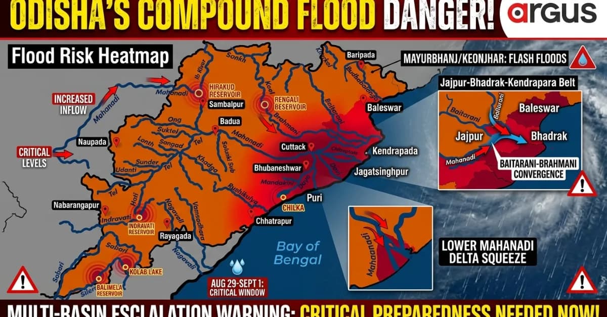
Model guidance points to heavy to very heavy rainfall over vulnerable pockets, particularly across catchments feeding the Baitarani, Brahmani and Mahanadi systems, while northern coastal river basins could also come under renewed pressure.
When the previous flood-producing system has left several catchments saturated, under such conditions, a substantial part of the fresh rainfall can quickly turn into surface runoff, rushing into rivers and reservoirs.
Baitarani-Brahmani: The Most Dangerous Overlap
The Baitarani basin is emerging as one of the most vulnerable zones in the coming days.
The CWC forecast indicates that the river at Akhuapada is expected to face renewed pressure during the August 29-31 window, with the forecast showing a secondary rise that could keep the river above or around its 18.33-metre danger level. The primary concern is for Jajpur and Bhadrak, where prolonged high flow could intensify rural flooding, embankment stress and waterlogging.
The threat does not end with the Baitarani.
The Brahmani basin is also facing a difficult reservoir situation. CWC projections point to a renewed rise in inflows into Rengali Reservoir around August 29-30, with the forecasted inflow rising sharply towards August last week and September first week.
With Rengali already carrying high storage, another heavy rainfall episode over the catchment could increase pressure on reservoir management and downstream river discharge. The districts that could face renewed flood stress include Angul, Dhenkanal, Jajpur and Kendrapara.
The bigger risk is the convergence of the two systems downstream.
If the Baitarani remains swollen while renewed Brahmani inflows and downstream releases build up, the flood burden could spread across the Jajpur-Bhadrak-Kendrapara belt, turning what are normally separate river threats into a multi-river inundation crisis.
Mahanadi Basin: Threat Renewed?
The Mahanadi basin presents another dangerous scenario.
The CWC forecast shows that after the ongoing high inflow phase, Hirakud could receive another significant inflow rise towards August 31 and September 1. That means authorities may have to continue managing high inflows even as the fresh Bay low-pressure system begins producing another round of rainfall.
Water released from the upper Mahanadi takes time to travel towards the delta. If renewed heavy rainfall, as the model forecasts predict, simultaneously affects Cuttack, Puri, Khordha and Jagatsinghpur, the lower Mahanadi system could face a double squeeze –large volumes arriving from upstream and fresh local runoff entering already swollen distributaries.
The result could be widespread waterlogging and flooding across the lower Mahanadi delta, especially in low-lying areas where drainage could become severely restricted.
The vulnerable river network includes the Mahanadi’s downstream channels and deltaic systems such as the Daya, Bhargavi and Kusabhadra, while the wider flood threat could extend into Cuttack, Puri, Khordha, Jagatsinghpur and Kendrapara.
Flash Floods Forecast For Northern Odisha?
The northern districts could experience the immediate impact of intense rainfall.
Model indications place Keonjhar and Mayurbhanj among the areas vulnerable to heavy rainfall over upper catchments and hilly terrain. Such rainfall could trigger sudden swelling in tributaries and streams feeding the Baitarani and other river systems.
Balasore also remains highly exposed because of the Subarnarekha, Budhabalanga and Jalaka river systems. The concern here is not only local rainfall but also runoff arriving from upstream catchments. The flood-sensitive belt includes areas such as Basta, Jaleswar and Baliapal.
With the Jalaka already under pressure and the Baitarani facing renewed flood potential, another intense rain spell could quickly transform localized flooding into a wider northern Odisha flood emergency.
Western Odisha Not Outside Danger Zone
The system’s rainfall footprint could also extend into western Odisha and the upper catchment zones.
Sambalpur, Deogarh and Jharsuguda could face heavy rainfall, localized flash flooding and urban inundation if intense rain bands develop over the Hirakud catchment.
A heavy rainfall episode over western Odisha could increase inflows into Hirakud, while simultaneous rain over northern Odisha could push the Baitarani and Brahmani systems higher. At the same time, coastal districts could receive direct rainfall from the low-pressure circulation.
In other words, multiple river basins could be receiving fresh water at nearly the same time.
Aug 29-Sept1: Critical Window for Which Districts?
The models highlight a concentrated zone of high precipitation ranging from 8 cm to over 32 cm of daily accumulation tracking across coastal and adjoining interior areas
The districts that would bear the brunt include:
North Coastal: Jajpur, Bhadrak, Baleswar, Kendrapada and Jagatsinghpur
North Interior: Mayurbhanj, Keonjhar and Parts of Sundargarh
Central & Inland belt: Dhenkanal, Cuttack, Puri, Khordha, including Bhubaneswar, Puri.
Keonjhar and Mayurbhanj – intense rainfall, flash floods and upper catchment runoff
The Bottomline
Odisha is staring at a potential multi-basin flood escalation, owing to several hydrological threats that may overlap.
A fresh Bay of Bengal low-pressure system around August 29-30 could bring another round of heavy rainfall before the present floodwaters and reservoir inflows have fully receded. The Baitarani could face a renewed danger-level rise, Rengali may come under fresh inflow pressure, Hirakud could encounter another surge, and the lower Mahanadi delta may simultaneously receive direct rainfall.
This is the warning window.
It is high time authorities move beyond routine flood monitoring and begin immediate multi-basin preparedness – with pre-positioning of rescue teams, round-the-clock reservoir coordination, embankment surveillance, evacuation planning for vulnerable villages and advance warnings for low-lying areas.
The next low-pressure area may still be several days away. But if the forecast signals hold, Odisha could have very little time to prepare once the new rainfall begins.
The immediate priority must therefore be clear: mitigate the risk before the weather system and the floodwaters converge.
Related Topics
Explore more stories