NOAA's 63% El Nino Warning: A 2015-16 Scale Is Back on the Climate Radar; What It Means for Odisha, India| Special Story

Key Points
* Odisha could face below-normal monsoon rainfall, prolonged dry spells, agricultural stress and weaker Bay of Bengal weather systems.
* A strong El Niño may reduce cyclone landfalls on Odisha while triggering hotter days and a warmer-than-normal winter.
Bhubaneswar: The world's climate watchdog has raised the possibility of a major Pacific warming event with consequences stretching far beyond the ocean basin.
NOAA's National Weather Service has Thursday officially declared the onset of El Niño and says there is a 63% probability that sea-surface temperatures in the monitored Pacific region will exceed 2°C above normal later this year – a threshold NOAA classifies as a "Very Strong El Niño."
Such events
are rare. Over the past four decades, only a handful – including the historic 1982-83,
1991-92, 1997-98 and 2015-16 episodes – have crossed into this category. Those years
reshaped weather patterns worldwide and significantly influenced India's
monsoon behaviour.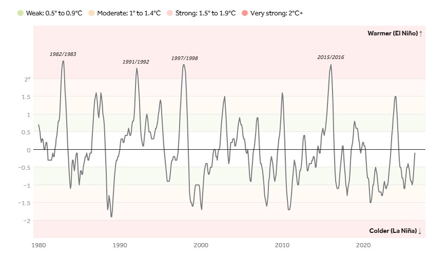
For Odisha, the comparison is especially relevant. The state's rainfall, agriculture, cyclone activity and winter temperatures have historically shown sensitivity to strong El Niño conditions.
If the current Pacific warming follows the trajectory NOAA is now warning about, Odisha could once again confront a familiar climate pattern: weaker monsoon spells, moisture stress across interior districts, fewer Bay of Bengal cyclones and an unusually warm winter.
Odisha's Monsoon Outlook: What a 2015-Type El Niño Could Mean
Among eastern Indian states, Odisha is particularly dependent on Bay of Bengal weather systems for seasonal rainfall.
A strong El Niño typically weakens these systems.
June: A Slow Beginning
The monsoon may make onset over the whole State by June 17/18 but struggle to gain momentum.
Rainfall will remain below normal, worse than 2015, when the State had near normal rainfall.
July: Deficits Begin to Deepen
July could emerge as the first major stress month.
Large parts of Odisha may slip into rainfall-deficit territory as monsoon depressions become less frequent.
Agricultural operations dependent on consistent rainfall could begin facing challenges.
August: Peak Monsoon Under Pressure
Normally the wettest phase of the season, August may witness suppressed rainfall activity.
Warmer Pacific waters often reduce the formation and strength of Bay depressions that bring sustained rain to Odisha.
Interior districts could experience prolonged dry spells.
September: Early Weakening
Monsoon circulation may weaken earlier than normal.
Rainfall could become highly erratic, leaving moisture deficits unfilled before the agricultural season ends.
Which Parts of Odisha Face Maximum Risk?
The greatest concern would likely be concentrated in:
Western Odisha
📱 Get Argus News App
✨- Sambalpur
- Bargarh
- Bolangir
- Nuapada
- Kalahandi
These districts are historically vulnerable to rainfall variability and agricultural drought.
Interior Odisha
- Angul
- Dhenkanal
- Sonepur
- Boudh
Rain-fed farming areas could experience significant soil moisture stress.
Coastal Belt
The coast may perform relatively better due to occasional localized weather systems, but seasonal totals could still remain below average.
The Cyclone Paradox: Fewer Threats for Odisha?
One of the lesser-discussed impacts of a strong El Niño is its influence on cyclone tracks.
Contrary to popular perception, a powerful El Niño does not necessarily mean more cyclones for Odisha.
Why?
Strong El Niño events often increase wind shear over the northern Bay of Bengal.
That wind shear can disrupt developing cyclones before they intensify or reach Odisha's coastline.
Possible 2026 Scenario
If a 2015-like pattern emerges:
- Fewer direct cyclone landfalls on Odisha.
- Cyclone genesis shifts southward.
- Systems increasingly track toward Tamil Nadu and Sri Lanka.
- Northern Bay activity remains subdued.
For Odisha, this could reduce storm risk but also eliminate an important source of post-monsoon rainfall.
A Hotter Odisha Beyond the Monsoon
The consequences of a strong El Niño often continue well after the rainy season.
Climate analogues suggest:
Warmer Winters
Night temperatures may remain higher than normal.
Reduced Winter Cooling
The typical winter chill across eastern India could be substantially weaker.
India Beyond Odisha: The National Picture
Central India
(Madhya Pradesh, Maharashtra, Chhattisgarh)
- High probability of rainfall deficiency.
- Agricultural drought concerns.
- Significant stress on reservoirs.
Northwest India
(Rajasthan, Punjab, Haryana, Uttar Pradesh)
- Severe rainfall shortages.
- Earlier monsoon withdrawal.
Southern Peninsula
(Telangana, Andhra Pradesh, Karnataka)
- Uneven rainfall distribution.
- Sharp regional contrasts.
- Strong dependence on localized weather systems.
Northeast India
(Assam, Arunachal Pradesh and adjoining areas)
- Comparatively insulated due to terrain-driven rainfall.
- Near-normal conditions possible, though below long-term averages. Also Read: Bhubaneswar, Puri, Cuttack May Wait Another Week; Gajapati to Malkangiri Likely to See Monsoon Onset by June 13–14 | Exclusive Analysis
Related Topics
Explore more stories