Odisha Heatwave Alert / IMD Shocker Forecast For Odisha: Heatwave to sweep Bhubaneswar, Cuttack; Jharsuguda to 'Tatlagarh' Breathe Cool Weather In May
·2 months ago·4 min read
Key Points
While Sambalpur might stay at 41°C due to storm clouds, Bhubaneswar and Puri may feel like 48°C because the trough is trapping moisture without providing the full storm reset seen in the interior.
Bhubaneswar: April sky breathed fire over western Odisha. Jharsuguda, State's coal power house, had been on boil last month with mercury kept fretting and fuming at over 44 deg C. The whole of the western region of the State has been nicknamed as the 'The Hot Plate' of Odisha. With April spewing gruelling fire, May was being seen as harsher and the gruelest.
But IMD has dropped a weather twister for May. The country's premier weather forecaster dropped a shocker of short.
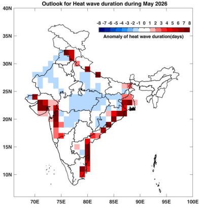
From Jharsuguda to Titlagarh – say Tatlagarh, will be having a cooler May this summer. But the coastal hotspots like Bhubaneswar, Cuttack, Puri to Gopalpur, who all have the luxury of availing the cool sea breeze that tones down the gruelling heat, will have to brace up for more heatwaves.
THE TWISTER EXPLAINER
In order to decode the IMD twister, a detailed glance at raw weather maps of NCMWRF (National Centre for Medium Range Weather Forecasting) unravels the big IMD cool story.
The national forecaster bet on below normal maximum tempertaure and below normal heatwave in the hot plate region of Odisha, despite gushing of strong dry westerlies into India and Odisha.
Weather maps suggest gushing westerlies, labelled as the blowtorch, at 1.5km above mean sea level, but little up at 3.1 km from mean sea level, the script of cooler May has been scripted.
The westerlies at approx. 3.1 km get denuded in the strenght. And here lies the catch.
With these winds losing momentum, this vertical decoupling is a classic setup for localized but intense weather.
While the westerlies are strong up to 1.5km from mean sea level, they turn weaker at 3.1 km. This creates Vertical Wind Shear – When the lower winds are faster than the mid-level winds, it can actually help tilt thunderstorm cells, allowing them to last longer rather than raining themselves out quickly.
A 360-degree look at the atmosphere over Odisha reveals a fascinating split-level war. At the 1.5 km level (850 hPa), a "Hot Ridge" is trying to bake the state. But just 1.5 km higher, at the 3 km level (700 hPa), that ridge is crumbling.
The Result: The weak ridge at 3.1 km from mean sea level isn't strong enough to suppress air from rising.
If the "Hot Plate" of Western Odisha heats the surface enough, the air can punch through this weak 700 hPa ridge, using the moisture from the Odisha Trough to trigger those "heat-breaking" thundershowers.
Why IMD Predicts "Below Normal" Maxima for Western Odisha
Therefore, IMD’s below normal forecast for the hot-plate region (Sambalpur, Jharsuguda, Titlagarh) is likely based on Cloud Debris and Antecedent Moisture.
The Cooling Loop
Raw weather maps of NCMWRF shows while a weaker ridge persisting over north and central India at approx. 3.1km, the westerlies form a trough over Odisha.
The Result: Even if it doesn't rain, it will generate mid-level cloud cover (Altocumulus/Altostratus). These clouds block the direct Shortwave Radiation from the sun. In May, even 2–3 hours of midday cloud cover can keep a potential 46°C day down to 42°C.
Explaining The Critical Relief Valve
Strong winds at all levels usually mean Dry Heat. But when mid-level winds weaken, it allows the heat rising from the ground to condense into clouds.
The Result: This is the primary reason the IMD expects Western Odisha to stay "below normal."
The region will likely see a high frequency of "High-Based" thunderstorms that provide cooling shade and erratic rain, breaking the heatwave cycle.
The Coastal Disadvantage Persists
Unfortunately, the 700 hPa trough sits right over the Odisha-Andhra coast. While a trough usually brings rain, at this altitude, it is also pulling in moisture that increases the Humidity Index.
The Verdict: While Sambalpur might stay at 41°C due to storm clouds, Bhubaneswar and Puri may feel like 48°C because the trough is trapping moisture without providing the full storm reset seen in the interior.
Also Read: Kalbaisakhi Storms Bring Relief To Odisha; Lightning Kills One In Balangir
But IMD has dropped a weather twister for May. The country's premier weather forecaster dropped a shocker of short.
From Jharsuguda to Titlagarh – say Tatlagarh, will be having a cooler May this summer. But the coastal hotspots like Bhubaneswar, Cuttack, Puri to Gopalpur, who all have the luxury of availing the cool sea breeze that tones down the gruelling heat, will have to brace up for more heatwaves.
THE TWISTER EXPLAINER
In order to decode the IMD twister, a detailed glance at raw weather maps of NCMWRF (National Centre for Medium Range Weather Forecasting) unravels the big IMD cool story.
The national forecaster bet on below normal maximum tempertaure and below normal heatwave in the hot plate region of Odisha, despite gushing of strong dry westerlies into India and Odisha.
Weather maps suggest gushing westerlies, labelled as the blowtorch, at 1.5km above mean sea level, but little up at 3.1 km from mean sea level, the script of cooler May has been scripted.
The westerlies at approx. 3.1 km get denuded in the strenght. And here lies the catch.
With these winds losing momentum, this vertical decoupling is a classic setup for localized but intense weather.
While the westerlies are strong up to 1.5km from mean sea level, they turn weaker at 3.1 km. This creates Vertical Wind Shear – When the lower winds are faster than the mid-level winds, it can actually help tilt thunderstorm cells, allowing them to last longer rather than raining themselves out quickly.
A 360-degree look at the atmosphere over Odisha reveals a fascinating split-level war. At the 1.5 km level (850 hPa), a "Hot Ridge" is trying to bake the state. But just 1.5 km higher, at the 3 km level (700 hPa), that ridge is crumbling.
The Result: The weak ridge at 3.1 km from mean sea level isn't strong enough to suppress air from rising.
If the "Hot Plate" of Western Odisha heats the surface enough, the air can punch through this weak 700 hPa ridge, using the moisture from the Odisha Trough to trigger those "heat-breaking" thundershowers.
Why IMD Predicts "Below Normal" Maxima for Western Odisha
Therefore, IMD’s below normal forecast for the hot-plate region (Sambalpur, Jharsuguda, Titlagarh) is likely based on Cloud Debris and Antecedent Moisture.
The Cooling Loop
Raw weather maps of NCMWRF shows while a weaker ridge persisting over north and central India at approx. 3.1km, the westerlies form a trough over Odisha.
The Result: Even if it doesn't rain, it will generate mid-level cloud cover (Altocumulus/Altostratus). These clouds block the direct Shortwave Radiation from the sun. In May, even 2–3 hours of midday cloud cover can keep a potential 46°C day down to 42°C.
Explaining The Critical Relief Valve
Strong winds at all levels usually mean Dry Heat. But when mid-level winds weaken, it allows the heat rising from the ground to condense into clouds.
The Result: This is the primary reason the IMD expects Western Odisha to stay "below normal."
The region will likely see a high frequency of "High-Based" thunderstorms that provide cooling shade and erratic rain, breaking the heatwave cycle.
The Coastal Disadvantage Persists
Unfortunately, the 700 hPa trough sits right over the Odisha-Andhra coast. While a trough usually brings rain, at this altitude, it is also pulling in moisture that increases the Humidity Index.
The Verdict: While Sambalpur might stay at 41°C due to storm clouds, Bhubaneswar and Puri may feel like 48°C because the trough is trapping moisture without providing the full storm reset seen in the interior.
Also Read: Kalbaisakhi Storms Bring Relief To Odisha; Lightning Kills One In Balangir
📱 Get Argus News App
✨📰 60 Word News🎬 Argus Podcast📺 Live TV and Breaking News🔔 Free Notification Alerts
Download Free:
Related Topics
Explore more stories