



EXCLUSIVE| Odisha Entry Point Confirmed: Deep Depression May Track Over Paralakhemundi; Next 48 Hours Critical as CWC Forecasts Jalka & Severe Vamsadhara Floods
Key Points
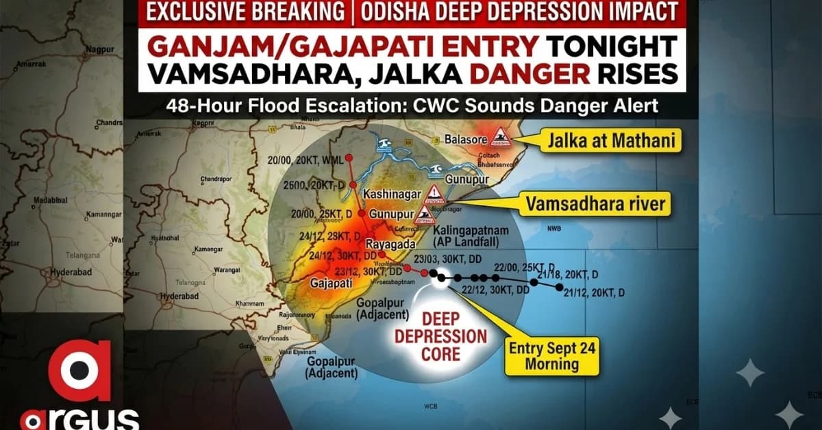
A Deep Depression from the Bay of Bengal is set to make landfall near Kalingapatnam tonight, moving inland into southern and western Odisha. September 24–25 marks the critical 48-hour flood window, with heavy rainfall expected to trigger massive runoff across multiple districts.
The Central Water Commission (CWC) warns that the Vamsadhara and Jalka rivers will significantly exceed danger marks, causing severe flood risks.
Bhubaneswar: Odisha is staring at a rapidly
escalating flood threat as the Deep Depression over the Bay of Bengal is set to
cross the North Andhra Pradesh-South Odisha Coast close to Kalingapatnam
tonight, before moving northwestwards deep into southern and western
Odisha.
The system, which intensified into a Deep Depression over
the westcentral and adjoining northwest Bay of Bengal, is forecast to cross the
coast between Visakhapatnam and Gopalpur, close to Kalingapatnam, by the
night of September 23. IMD's latest bulletin confirms the
west-northwestward movement and the expected landfall window.
What makes the situation more serious for Odisha is not
merely the rainfall during landfall. The system is expected to travel inland
across the Gajapati-Rayagada-Kalahandi belt, dumping heavy rain over
already vulnerable catchments and sending a sharp pulse of runoff into rivers.
And the Central Water Commission's flood forecast points
to a 24-48-hour escalation window, with the most critical phase expected
from September 24 afternoon through September 25 night.

📱 Get Argus News App
✨Landfall tonight: Kalingapatnam first, Odisha next
The Deep Depression is expected to cross near Kalingapatnam
in Andhra Pradesh late Wednesday, September 23, before entering the
southern Odisha region.
The projected inland trajectory takes the system across
the Ganjam–Gajapati sector, with the circulation then moving
northwestwards towards Paralakhemundi, Rayagada, Kalahandi
and subsequently towards Nabarangpur, Bolangir and Nuapada, before
weakening further towards Chhattisgarh.
IMD's latest official position places the system over the
westcentral/adjoining northwest Bay of Bengal and maintains the forecast of a
land crossing close to Kalingapatnam by tonight.
The track and impact window
| Time |
Expected system position |
Wind scenario |
Main Odisha areas under impact |
| Sept 23 evening-night |
Landfall near Kalingapatnam |
50-60 kmph, gusting up to 70 kmph |
Ganjam, Gajapati, coastal Andhra adjoining Odisha |
| Sept 24 morning |
Inland across Gajapati–Rayagada/Koraput belt |
45-55 kmph, gusting up to 65 kmph |
Paralakhemundi, Rayagada, Koraput |
| Sept 24 evening-night |
Weakening while moving northwest |
40-50 kmph, gusting up to 60 kmph |
Nabarangpur, Kalahandi, Bolangir |
| Sept 25 |
Depression/remnant system approaching Chhattisgarh |
30-45 kmph, gradually weakening |
Nuapada, Bargarh and adjoining western Odisha |
The strongest winds are expected close to the circulation
during and immediately after landfall, with the system weakening progressively
as it moves over land and encounters the Eastern Ghats.
Rainfall will move from South Odisha to the western districts
The rainfall pattern is expected to shift westward with
the system.
During the night of September 23 through September 24, Ganjam, Gajapati, Rayagada and Koraput could receive 110–200 mm, with isolated pockets potentially exceeding 250 mm under the strongest convective bands.
The next major rainfall zone is expected to develop
across Kalahandi, Nabarangpur, Bolangir and Nuapada, where 70–150 mm
is possible during September 24-25.
The danger is that the rain may not appear as one
uninterrupted deluge everywhere. The system's asymmetric and sheared structure
means districts can experience shorter but extremely intense convective
spells, separated by comparatively quieter periods.
CWC flood forecast: rivers begin responding within hours
The more consequential development is now downstream.
According to the flood forecast inputs, river levels are
expected to rise rapidly as the Deep Depression's rainfall enters the
catchments.
Three monitoring locations stand out:
- Jalka at Mathani, Balasore
- Vamsadhara at Kashinagar, Gajapati
- Vamsadhara at Gunupur, Rayagada
For reference, CWC's flood-monitoring framework lists 6.00
m as the warning level and 6.50 m as the danger level at Jalka-Mathani. For
Vamsadhara, the corresponding levels are 54.10/54.60 m at Kashinagar and
83.00/84.00 m at Gunupur.
The critical river timeline
|
Time |
River / location |
Forecast development |
Flood significance |
|
Sept 23 |
Jalka–Mathani |
River approaches warning level |
Initial catchment response |
|
Sept 24, 6–9 AM |
Jalka–Mathani |
Crosses 6.50 m danger level |
Flooding risk begins intensifying |
|
Sept 24, 9 AM–12 PM |
Vamsadhara–Kashinagar |
Crosses 54.10 m warning, then 54.60 m danger |
Rapid escalation in Gajapati |
|
Sept 24 evening-night |
Vamsadhara–Gunupur |
Crosses 83.00 m warning level |
River stress spreads into Rayagada |
|
Sept 25 early hours |
Jalka–Mathani |
Forecast to cross 7.31 m HFL |
Exceptional flood response |
|
Sept 25, 3–9 AM |
Jalka–Mathani |
Peak around 8.0 m |
Extreme inundation window |
|
Sept 25, around 6 AM |
Vamsadhara–Gunupur |
Crosses 84.00 m danger level |
Major flood threat |
|
Sept 25 afternoon |
Vamsadhara–Kashinagar |
Peak around 57.7 m |
About 3.1 m above danger level |
|
Sept 25 afternoon |
Vamsadhara–Gunupur |
Peak around 85.4 m |
Significant exceedance of danger level |
|
Sept 26 |
Vamsadhara |
Rapid recession expected |
Flood pressure starts easing |
|
Sept 26 night |
Jalka–Mathani |
Falls below danger level |
Prolonged flood phase begins to recede |
September 24–25: Odisha's most critical 48 hours
The CWC forecast therefore changes the nature of the
weather threat.
September 23 is primarily the landfall and rainfall
onset phase. September 24 becomes the river-rise phase. September 25 emerges as
the peak flood-risk day.
In southern Odisha, the immediate concern will be intense
runoff from Gajapati and Rayagada, particularly around the Vamsadhara
basin.
Kashinagar and Gunupur become particularly
important because the forecast river levels move substantially beyond their
respective danger marks.
The projected 57.7-metre peak at Kashinagar,
against a danger level of 54.6 metres, would put the river roughly 3.1
metres above the danger threshold.
At Gunupur, the forecast peak of about 85.4
metres would be around 1.4 metres above the 84-metre danger level.
The consequence is not limited to the immediate
riverbank. Rising rivers can back up tributaries and drainage channels,
inundate low-lying settlements, disrupt roads and bridges and isolate pockets
where access becomes difficult.
Cities and towns likely to see the weather transition
The immediate southern corridor includes Kalingapatnam
(AP), Paralakhemundi, Rayagada, Gunupur and Kashinagar.
The flood threat will outlive the weather system
This is perhaps the most important distinction in the current forecast.
The Deep Depression is expected to weaken after moving
inland. But rivers do not respond and recede at the same speed as the
atmospheric system.
Even after rainfall starts declining on September 25,
runoff from upstream catchments can continue feeding the rivers.
That is why the flood forecast extends into September
26, with Vamsadhara expected to begin falling earlier while Jalka could
remain above its danger level for more than 36 hours.
The weather system may therefore be weakening by the time
the flood threat reaches its most consequential phase.
The bottom line
Tonight's landfall near Kalingapatnam triggers the
bigger Odisha risk as the system moves inland.
The sequence projected by the rainfall and flood
forecasts is stark: heavy rain over South Odisha on September 23–24, rapid
river response on September 24, peak flood conditions on September 25 and
gradual recession only on September 26.
For Gajapati and Rayagada, the Vamsadhara is the
immediate concern. For Balasore, the Jalka forecast points to a later
but potentially severe river response.
The next 48 hours will therefore determine whether the
Deep Depression remains primarily a heavy-rain event or develops into a
broader river-flood episode across multiple Odisha districts.
Related Topics
Explore more stories