



EXCLUSIVE| Hirakud flood pulse to hit Cuttack hard: Significant waterlogging likely till Sept 29, Check Your Place!
Key Points
The Mahanadi river stage at Cuttack is forecast to peak at around 26.30 meters between September 27 night and September 28 midnight.
Rising river levels are creating a hydraulic drainage-lock effect, trapping local runoff inside the city without fresh rainfall.
Downstream districts like Bhubaneswar, Puri, and Jagatsinghpur remain outside the active inundation zone.
Bhubaneswar:
The next flood pulse from the Mahanadi is set to make Cuttack the
centre of the flood impact, with the Central Water Commission (CWC)
forecast showing the river stage at Cuttack climbing to around 26.30
metres – just below the danger level of 26.41 metres – and
creating significant, prolonged waterlogging in low-lying parts of
the city.
The forecast peak is expected between September 27 night and
September 28 midnight, while the CWC inundation map indicates that
the water will remain pooled across the Cuttack reach until September
29 morning.
The important relief: the flood pulse does not translate into a comparable downstream flood threat for Bhubaneswar, Puri or Jagatsinghpur, with the CWC forecast keeping the southern and eastern downstream systems outside the active inundation zone.
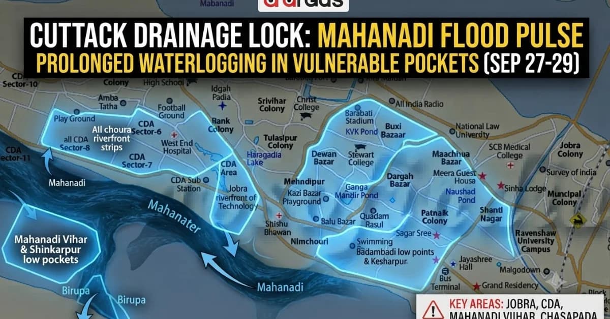
Breaking: These Cuttack areas face prolonged waterlogging
The immediate urban concern is not a fresh spell of rain but the high Mahanadi stage locking Cuttack's drainage system. The CWC inundation assessment identifies several vulnerable pockets where waterlogging may persist until September 29 morning.
|
Cuttack city area |
|---|

📱 Get Argus News App
✨Expected impact
Jobra and riverfront fringe wards
Backwater pooling around the Jobra barrage and adjoining low-lying settlements
Mahanadi Vihar & Shikarpur low pockets
Drainage surcharge and backwater entering low-lying streets
CDA sectors near Ring Road
Water accumulation in the lowest blocks and open areas near the river perimeter
Sati Choura & Bidanasi riverfront strips
Overbank flooding of low-lying riverbank pockets and settlements
Chasapada & outer northern suburbs
Sheet flooding in low-lying agrarian-urban transition areas
Badambadi low points & Kesharpur
Prolonged internal waterlogging because drainage outlets face high river pressure
The CWC assessment specifically identifies Jobra, Mahanadi Vihar, Chasapada and low-lying Cuttack urban sectors as vulnerable during the high-water window.
Why Cuttack can waterlog even without downstream rain
The crucial point is that Cuttack's waterlogging is being driven by river level, not by fresh rainfall over the city. The Mahanadi branches around Cuttack, and the city's drainage outlets depend on being able to discharge water into the river system. When the river rises sharply, those outlets face a hydraulic lock.
The forecast indicates a 0.5–1 metre localised rise/inundation effect around the Cuttack–Kishan Nagar reach, while the Cuttack gauge itself is projected at about 26.30 metres.
In the city, this produces a classic backwater or drainage-lock situation. As the Mahanadi rises above the level at which urban drains can freely discharge, sluice gates have to remain closed or heavily restricted to prevent river water from flowing backwards. Consequently, even without significant rain over Cuttack, existing runoff and local drainage water can remain trapped inside low-lying wards.
That is why a seemingly limited 0.5–1 metre localised water rise can produce much greater disruption on the ground. Riverfront pockets can face direct overbank flow, while internal urban depressions experience stagnant water because the city's drainage network cannot empty efficiently into an already swollen river.
Beyond Cuttack city: Other pockets facing inundation
The flood impact is not confined to the municipal limits. The CWC inundation map places a series of villages and low-lying agricultural areas inside the active flood swath between the Mahanadi apex around Naraj/Mundali and the Kishan Nagar reach.
|
Zone |
Places identified in the inundation area |
Expected situation |
|---|---|---|
|
Upper delta bottleneck |
Talagarh, Nuadi, Mundali fringes, Arilo (west) |
Slow recession; low-lying riverine and agricultural areas remain waterlogged |
|
Northern catchment strip |
Bamanapur, Paikerapur, Similihanda, southern edge of Choudwar |
Sheet flooding and water retention on flat lowlands |
|
Cuttack fringe |
Jobra, Mahanadi Vihar low patches, Chasapada |
Urban drainage lock and prolonged waterlogging |
|
Mid-delta branching zone |
Patap, Kunheinara, Kalarabank, Urali, Inathpur |
Agricultural lowlands and connecting roads remain vulnerable to water retention |
|
Kishan Nagar terminal reach |
Sugad, Jatana, Kuri, Barbodila |
Flood pulse slows and pools against local embankments |
The CWC map identifies the active inundation swath as extending through these upper and mid-delta locations, with the easternmost extent of the mapped flooding stopping at Kishan Nagar.
Why the flood pulse tapers down from Kishan Nagar
The
most significant feature of this forecast is the sharp
weakening of the flood pulse downstream of Cuttack.
The CWC data shows Cuttack reaching around 26.30
metres,
while the Kishan Nagar forecast is only around 12.75
metres,
below its stated normal threshold of 13.90 metres. Tarapur, Balakati,
Balanga and Nimapara are also forecast below their respective normal
levels.
There are two main reasons. First, after Cuttack the
Mahanadi splits
into multiple distributaries,
including the Kathajodi, Kuakhai and Birupa, dispersing the flood
volume instead of allowing the entire peak discharge to travel
through one downstream channel. Second, the Hirakud inflow is already
declining sharply, meaning the event behaves more like a
short-duration
flood pulse than a continuously replenished flood wave.
As a result, the CWC inundation assessment places the direct flood impact within Cuttack district, while the neighbouring districts remain outside the mapped active flood zone.
|
District |
CWC flood status in this pulse |
Reason |
|---|---|---|
|
Cuttack |
Active flood/inundation zone |
Direct impact of the Mahanadi main-stem flood pulse |
|
Jagatsinghpur |
No direct impact indicated |
Flood swath terminates before the downstream district |
|
Kendrapara |
No direct impact indicated |
Remaining flow in distributaries stays below warning thresholds |
|
Puri |
No direct impact indicated |
Kuakhai and Bhargavi systems remain outside the mapped hazard zone |
|
Khordha |
No direct impact indicated |
Southern delta channels remain at non-threatening stages |
For
Cuttack, the operational focus therefore remains on the
city and vulnerable riverine/low-lying pockets of the district,
rather than treating this as a statewide downstream flood event. The
CWC assessment specifically identifies Cuttack
Town, Banki, Athagarh, Salepur and the Kishan Nagar border blocks
for attention.
Also Read: EXCLUSIVE | Deep Depression: Hirakud Dam May Be Forced to Open 14 Gates to Flush 2.8 Lakh Cusecs Inflow in next 48 hours!
Related Topics
Explore more stories