



EXCLUSIVE| Deep Depression Rain Triggers Flood Calamity In Odisha: Vamsadhara, Baitarani Cross Danger Mark; More Rivers Rising
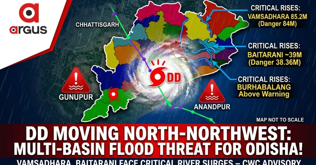
Key Points
Vamsadhara Danger: The Vamsadhara river at Gunupur is forecast to surge to around 85.2 metres, crossing its 84-metre danger level and causing severe inundation.
Multi-Basin Threat: Severe flood alerts are active across multiple river basins, with Baitarani and Burhabalang also expected to cross critical danger or warning marks.
Active Deep Depression: The deep depression tracking northwest through southern and interior districts continues to feed heavy rain bands and high-risk runoff across Odisha.
Bhubaneswar: The Deep Depression (DD) that moved inland over southern Odisha is now translating its enormous rain-bearing cloud mass into a multi-basin flood threat, with the Central Water Commission’s September 24 advisoryforecasting critical river surges in parts of the State.
The
immediate danger is no longer confined to rainfall. Vamsadhara
at Gunupur is forecast to rise to around 85.2 metres, well above its
84-metre danger level; Baitarani at Anandpur is projected to touch
around 39 metres against a 38.36-metre danger mark; while Budhabalang
at Govindpur has already crossed its warning level and is forecast to
approach the danger mark.
At
the same time, the flood picture is sharply uneven. The Brahmani at
Jenapur remain below their respective warning levels.
DD Now Over Southern Odisha: The State Has Another 24 Hours Of High-Risk Rain
The DD is currently positioned inland near the Malkangiri-Koraput area, after moving past Padmapur, and is tracking north-northwest towards the Chhattisgarh border.

📱 Get Argus News App
✨Its passage through Odisha is expected to continue through September 25, with the system moving through Rayagada, Nabarangpur and Kalahandi before crossing into Chhattisgarh. The CWC flood scenario therefore overlaps with the period in which the DD's rain-bearing circulation is still active over the southern and interior districts.
The immediate movement window is:
|
District/zone |
Expected DD passage |
Main threat |
|---|---|---|
|
Rayagada |
Sept 24, afternoon/evening
Heavy rain, strong winds, river rise
Nabarangpur
Sept 24 night–Sept 25 morning
Extremely heavy rain, flash flooding
Kalahandi
Sept 25 morning–afternoon
Intense rain and flash-flood risk
Koraput-Malkangiri belt
Current/next phase
Heavy rain, runoff, local flooding
The table elaborates Rayagada's impact through Thursday evening, Nabarangpur's peak window from Thursday night into Friday morning and Kalahandi's major rain phase from Friday morning through afternoon.
Why The Rain Is Not Ending With The Centre's Passage
The satellite/cloud structure is particularly important to understanding the flood risk.
The DD has an asymmetrical cloud canopy, with the densest and most opaque clouds wrapped around its southern and eastern quadrants. A continuous moisture band is also being pulled from the Bay of Bengal into southern and interior Odisha.
That means the heaviest rain is not necessarily confined to the location of the circulation centre.
The rain-bearing convection is concentrated towards the right and rear/eastern and southern side of the track, allowing districts already passed by the centre to continue receiving heavy rainfall from trailing bands.
This is crucial from a flood perspective: the rain may persist over catchments even after the DD's core moves away. Runoff generated upstream can then reach rivers later, creating a delayed hydrological peak.
3 Southern Districts , 1 Western Under Direct Heavy-Rain Sweep
The core-track zone comprises Kalahandi, Nabarangpur, Koraput and Malkangiri, where IMD and other weather models indicate the possibility of extremely heavy rainfall exceeding 200 mm.
The eastern/trailing quadrant includes Rayagada, Gajapati, Ganjam and Kandhamal. These districts remain under the moisture-rich eastern arm of the circulation and therefore face continuing heavy rain, with the additional risk of landslides and river rises.
This creates two simultaneous flood mechanisms:
Direct rainfall flooding in the districts under the DD's core or heavy cloud bands.
Riverine flooding downstream as accumulated catchment runoff reaches rivers and raises gauge levels.
CWC's Extreme Flood Signal: First Godahada River in Ganjam District
The unprecedented rise of the Godahada River has primarily threatened the southern pockets of Ganjam:
The hydrograph shows a minor rise on September 22, which turned into an exponential surge starting mid-day September 23.
HFL Breach: Around 06:30 AM on September 24, 2026, the river officially breached its historical Highest Flood Level (HFL) of 32.1 meters.
Current Peak: By 12:30 PM, the level plateaued at ~32.84 meters, nearly 0.74 meters above the previous HFL. This marks a severe, life-threatening extreme flood situation demanding immediate emergency intervention.
Impacted Places: Patrapur Block (including Turupi and Kyagura villages), Kurula, and low-lying areas near the Ghodahada Reservoir. Landslides have also blocked the Tadakasahi-Ankuli road.
People Impacted: The administration has issued urgent alerts and initiated evacuations for thousands of residents across vulnerable riverside communities to safe shelter
Second: Vamsadhara River At Gunupur
The sharpest warning in the CWC advisory comes from the Vamsadhara at Gunupur.
The river is forecast to cross its 83-metre warning level and 84-metre danger level during September 24–25, with a projected peak of around 85.2 metres.
That would put the forecast peak more than a metre above the danger mark.
The CWC-based assessment therefore points to widespread inundation of low-lying areas around the affected river corridor, particularly as intense rainfall continues across Rayagada and Gajapati catchments.
Vamsadhara flood timeline
Sept
24–25:
rapid rise
Warning
mark:
83.0 m
Danger
mark:
84.0 m
Forecast
peak:
~85.2 m
Threat:
severe inundation of low-lying areas
The river is expected to gradually fall back below the warning level by Day 3.
Baitarani To Rise Aggressively: Anandpur Faces Flash-Flood Threat
The next major flood pulse is expected in the Baitarani basin.
At Anandpur, the CWC forecast shows a sharp rise beginning early on September 25, with the river projected to cross its 37.44-metre warning level and breach the 38.36-metre danger level.
The forecast peak is around 39 metres on September 25–26.
That represents a rise of roughly 0.64 metre above the danger mark.
The CWC assessment describes the expected event as a sharp and severe flash-flood episode before the water moves downstream.
Budhabalang Already Above Warning: Nearly 72 Hours Of Concern
The Burhabalang at Govindpur NH-5 Road Bridge is already in a stressed position.
Its observed level is around 7.4 metres, above the 7.21-metre warning level. The short-range forecast keeps the river on an upward trajectory, potentially taking it to or marginally above the 8.13-metre danger level during September 24–26.
Unlike a brief spike, the river is forecast to remain above the warning threshold for nearly 72 hours, creating the possibility of prolonged flooding in vulnerable low-lying locations.
Rushikulya: Warning-Level Crossing, But Not A Danger-Flood Scenario
The Rushikulya at Purushottampur presents a different picture.
The forecast peak is around 16.1 metres, marginally above its 15.835-metre warning level, but below the 16.835-metre danger level.
The river is expected to recede below 15 metres by September 27.
Therefore, the CWC-based assessment points towards localized agricultural inundation, temporary waterlogging and possible disruption on low-level roads and causeways rather than a widespread catastrophic flood.
Nagavalli Also Shows A Double-Peak Inflow
The Nagavalli system at Narayanpur Anicut/BG is showing another important signal – a double-peak inflow pattern.
After an initial surge, the second and stronger peak is forecast around September 26, reaching approximately 1,500 m³/sec.
The implication is the need for rapid downstream gate adjustments to manage localized flash-flood risk.
Brahmani: Rising, But Still Below Warning
The Brahmani at Jenapur is also forecast to rise, but remains within its warning parameters.
The river is projected to increase from around 19.5 metres to 21.8 metres, against a warning level of 22 metres and danger level of 23 metres.
The CWC-based assessment places this station in the safe category, with the river expected to plateau below warning.
Where The Ground-Level Impact Could Be Felt
The flood risk is not uniform across the State. The vulnerable locations identified in the source material include low-lying settlements along affected river corridors.
Ganjam
Around the Rushikulya/Godahada system, areas identified for close monitoring include:
Purushottampur town and low-lying suburbs
Pratappur
Chadhiapalli and nearby riverside hamlets
Singipur and adjoining panchayats
The Godahada corridor also includes Kurula, Turupi, Kyagura, Ankuli and Tadakasahi, with the source specifically identifying Kurula as being at the CWC gauge location and vulnerable to the reported high-flow situation.
Malkangiri
The Potteru Vagu corridor is another vulnerable zone.
The identified settlements include:
Poteru
Padganpalli
Kangrukonda
Maharajpalli
MV-79
MV-90
MV-96
Binayakpur
Alama
Peta
The river status also indicates with high possibility of road-submergence vulnerability along parts of this river system, particularly around the NH-326 corridor and low-lying settlements.
Odisha's Flood Map: Extreme At Three Rivers, Rising At Others
The CWC advisory produces a distinctly mixed flood map rather than a uniform State-wide flood.
|
River / system |
Station |
Forecast situation |
Flood implication |
|---|---|---|---|
|
Vamsadhara |
Gunupur |
~85.2 m; danger 84 m |
Severe inundation risk |
|
Baitarani |
Anandpur |
~39 m; danger 38.36 m |
Sharp flash-flood risk |
|
Burhabalang |
Govindpur |
Above warning; near danger |
Prolonged flooding risk |
|
Mahanadi inflow |
Hirakud |
~8,000 m³/sec |
Major reservoir inflow surge |
|
Nagavalli inflow |
Narayanpur |
~1,500 m³/sec |
Double-peak surge |
|
Rushikulya |
Purushottampur |
~16.1 m; below danger |
Localized flooding/waterlogging |
|
Brahmani |
Jenapur |
~21.8 m; below warning |
Steady but safe rise |
|
Mahanadi |
Naraj |
~24.3 m; below warning |
No immediate delta threat |
The distinction is critical: not every river in Odisha is heading towards a flood emergency, but several basins are simultaneously entering critical stages.
What The CWC Forecast Means On The Ground
For communities living beside the Vamsadhara, Baitarani and Burhabalang, the immediate concern is inundation as rivers cross or approach danger levels.
For southern Odisha, the concern is more immediate rainfall runoff, flash flooding and possible landslides as the DD continues through the interior.
And for smaller rivers such as Rushikulya, the danger lies less in a major riverine catastrophe and more in localized waterlogging, agricultural inundation and temporary road connectivity disruptions.
The CWC advisory therefore points to a highly localized but serious flood calamity: extreme river behaviour in some basins, above-normal or warning-level rises in others.
Also Read: EXCLUSIVE| Deep Depression Cloud Structure Revealed: Check How Your District Will See Heavy to Very Heavy Rainfall in Odisha
Related Topics
Explore more stories