



EXCLUSIVE| Cyclone Arnab to form past midnight: Which Odisha districts will its 'Muscular Right Arm' pound? Timeline inside

Key Points
Landfall Targeted Near Kakinada: Cyclone Arnab is projected to make landfall southwest of Kakinada on October 28 with gusting wind speeds reaching up to 140 kmph.
Red Alert for Coastal South Odisha: Ganjam and Gajapati face extremely heavy downpours (>200 mm) starting October 27 midnight as outer storm bands move inland.
Benign Mid-Level Shear Drives Tight Core: Exceptionally weak mid-atmospheric shear (5 knots) has allowed the system to rapidly consolidate strong northern and southern arms over open Bay waters.
Bhubaneswar: TWELVE HOURS to go for the Cyclone Arnab to take birth over bay waters. Latest satellite images show the system’s two arms (northern and southern) developing strong muscles as the consolidation of the cloud bands begins.
As the consolidation phase has started, the system from its earlier east-southeast drift has started tracking the west. It is now punching ahead with an increased wind speed.
As
the system chugs along its westward track, it confirms the IMD's initial
forecast. (see
the image below).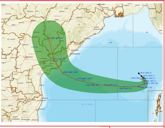
An analysis of the IMD track shows Cyclone Arnab making landfall with a gusting wind speed of 140 kmph just to the southwest (left) of Kakinada and Yanam. After crossing the coast, the track line advances northwestward, cutting directly through:

📱 Get Argus News App
✨o Eluru district
o Alluri Sitharama Raju district (western section)
o Crossing the border into eastern Telangana (near Bhadrachalam/Khammam regions) before curving up toward Chhattisgarh.
Why Zeroing on Kakinada: Steering holds the Clue
The meteorological dynamics at play over Bay of Bengal and mainland of India scripts the Cyclone Arnab’s destiny and mainland tracking. Data with CIMSS shows the mid-level shear is exceptionally weak. The storm center is locked in at a very benign 5 knots.
The Impact: Because the middle layers of the atmosphere are completely calm and moving in tandem with the low levels, the storm has been allowed to build a compact, tight core over the open water, explaining why its northern arm is developing dense muscles so quickly.
Given the mid-atmosphere is clam, it is the lower and upper level winds that are now guiding the Cyclone Arnab on its journey towards mainland. The CIMSS data portrays a locked-In Westward Path.
Since the atmospheric wind data suggest high vertical wind shear along the eastern coast of India, its long north arm would get sheared towards east dumping heavy rains over Odisha.
Based on the ECMWF model mapping and the official IMD multi hazard color-coded alerts, the region-wise time line breakdown has been organized below for precise citizen warnings:
South Odisha (Interior & Coastal)
The core landfall zone of Cyclone Arnab is projected to be at the left to the Kakinada (between Baptala and Vizag).
· Places Mapped: Ganjam (Berhampur, Chatrapur, Gajapati (Paralakhemundi), Rayagada, Koraput, Malakangiri
· Rain Commencement: October 26 night (from 9PM onwards), starting with sporadic rainbands from the outer rim of the cyclonic system.
· Heavy Rain Peak Window:
o Coastal South Odisha (Ganjam, Gajapati): Continuous heavy rain intensifies by October 27 morning (09:00 AM). Extremely Heavy Rain (>200 mm Red Alert) will slam these coastal areas from October 27 midnight through the entire day of October 28 as the eye of the storm nears the coast.
o Interior South Odisha (Rayagada, Koraput, Malkangiri): Heaviest downpours hit on October 28 early morning and persist until October 29 morning.
North Odisha Places
Northward moisture incursions will interact with continental air to bring heavy rainfall to coastal and interior northern districts.
· Places Mapped: Jagatsinghpur, Kendrapada, Bhadrak, Baleshwar, Jajpur, Mayurbhanj.
· Rain Commencement: October 27 morning (08:00 AM).
· Heavy Rain Peak Window: October 27 night through October 29 morning. Pockets in Jagatsinghpur and Kendrapada will experience Very Heavy Rainfall throughout October 28 due to proximity to the outer maritime storm wall.
West & Interior Odisha Places
As the cyclonic system recurves and moves inward, the remnants will transfer severe weather westward.
· Places Mapped: Kandhamal, Kalahandi, Nuapada, Balangir, Boudh, Sonepur, Samabalpur, Bargarh.
· Rain Commencement: Late afternoon on October 27.
· Heavy Rain Peak Window: Rain shifts deep into the interior, turning into a heavy downpour window between October 28 noon and October 29 late night. Interior catchments should monitor river channels for sudden surface run-offs.
IMPORTANT: Citizens should keep
emergency power backups ready and cross-verify local situational updates
directly with the IMD Bhubaneswar.
Also Read: EXCLUSIVE| Inside Cyclone Arnab’s Machinery: Why Ocean Dynamics Are Drawing Very Severe Storm to Andhra Coast over Odisha