



EXCLUSIVE | Cyclone Arnab Cloud Structure Revealed: 'Right Arm' to Bring Lashing Rains to Bhubaneswar, Cuttack – Check Timeline to Stay Safe

Key Points
Asymmetrical Cloud Topography: INSAT data reveals Cyclone Arnab has an elongated "right arm" that will continuously pump Bay moisture directly over coastal Odisha.
Core Winds vs. Rain Impact: The cyclone’s high-wind eyewall (up to 140 kmph) will hit Central Andhra Pradesh, leaving Odisha at risk for severe urban waterlogging rather than structural wind damage.
Peak Downpour Window for Twin Cities: Bhubaneswar and Cuttack face an Extreme Waterlogging Alert from October 28 morning to evening, with up to 120+ mm rain expected in a single 12-hour block.
Bhubaneswar: The cloud structure of Cyclone Arnab revealed. Currently in the East-central Bay of Bengal, the system exhibits a highly asymmetrical and sheared cloud topography. It has an "Elongated Right Arm."
With Cyclone Arnab having started gaining muscles late in afternoon, it seems by October 28, 2026 as it reaches its landfall window between Bapatla and Visakhapatnam on the morning of October 28, the cloud architecture will undergo a complete transformation:
· Core Consolidation & Symmetry: As the system rapidly intensifies into a Very Severe Cyclonic Storm (VSCS) over the Westcentral Bay of Bengal, the atmospheric spinning energy (vorticity) will force the sprawling "right arm" to tightly coil inward. The cloud pattern will shift from an asymmetrical comma-shape into a tightly wound, compact circular vortex.
· Formation of the Central Eye: The core will attempt to clear out a central, cloud-free eye structure, completely ringed by a dense, towering wall of convective clouds known as the Eyewall. This eyewall will hold the maximum core winds of 115–125 kmph gusting up to 140 kmph.

📱 Get Argus News App
✨· Odisha Rainbands: While the compact, destructive high-wind cloud core will be slammed directly against the Central Andhra Pradesh coast, its outer spiral rainbands – the remnants of that massive northeastern moisture field – will stay sheared to the north and east.
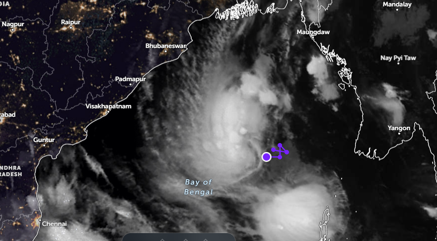
These dense, slow-moving outer cloud bands will remain draped over from Berhampur, Puri, Bhubaneswar, and Cuttack, and beyond, functioning as a continuous atmospheric pump that dumps heavy to extremely heavy rainfall across coastal and interior Odisha without bringing the core cyclonic winds up north.
The arm will behave like a rotating spiral band. Instead of a single brief shower, it will continuously feed moisture from the warm Bay of Bengal directly over coastal Odisha.
As a consequence, the primary operational risk for Bhubaneswar, Cutttack, Puri and Bramhapur is flash waterlogging and urban flooding. Because the system’s center will cross deep into central Andhra Pradesh, the cyclonic winds will stay far to the south. However, the elongated, moisture-rich northeastern cloud arm mapped by INSAT will continuously feed heavy rainbands directly over these key urban catchments.
Cyclone Arnab Rainfall Timeline For Twin Cities
To give the denizens of the twin cities a precise window for packing, cleaning yard drains, and planning safe indoor presence, the precipitation stages translate to the following timelines:
|
City / Location |
Rain Starts (Light/Scattered) |
Heavy Rain (>65 mm/24hr) |
Very Heavy Rain Window (>115 mm/24hr) |
Key Precaution Target |
|
Berhampur |
Oct 26
22:00 IST (Late Night) |
Oct 27
08:00 IST (Morning) |
Oct 27 Night – Oct 28 Noon |
Direct flash flooding risk; clear neighborhood exit routes. |
|
Puri |
Oct 26
23:30 IST (Midnight) |
Oct 27
14:00 IST (Afternoon) |
Oct 27 Midnight – Oct 28 Night |
Coastal waterlogging & high wave action; stay clear of sea-facing areas. |
|
Bhubaneswar |
Oct 27
03:30 IST (Early Morning) |
Oct 27
16:00 IST (Late Afternoon) |
Oct 28 Early Morning – Oct 29 Noon |
Severe street flooding; move vehicles to elevated/secure indoor parking early. |
|
Cuttack |
Oct 27
04:30 IST (Early Morning) |
Oct 27
18:00 IST (Evening) |
Oct 28 Morning – Oct 29 Evening |
Prolonged arterial road blockages; charge devices & secure power backups. |
6-Hour Rain Accumulation & Waterlogging Risk Tracker
Bhubaneswar & Cuttack (Twin Cities)
The ECMWF and regional models map high-volume precipitation delivered in compact 6-hour windows. Densely built urban zones will face severe stress because runoff cannot escape rapidly enough into natural channels:
· Oct 27 (06:00 to 12:00 IST): 5–15 mm. Low Risk. Mostly localized thundershowers and cloudy intervals. Roads will remain fully navigable.
· Oct 27 (12:00 to 18:00 IST): 20–40 mm. Moderate Risk. Runoff begins filling secondary roadside drains. Low-lying basements should monitor entry gates.
· Oct 27 (18:00) to Oct 28 (06:00 IST): 40–70 mm. High Risk. Continuous moderate downpours overnight. Water will accumulate on peripheral highways and underpasses.
· Oct 28 (06:00 to 18:00 IST) — PEAK DOWNPOUR: 80–120+ mm packaged within this single 12-hour stretch. Extreme Waterlogging Alert. Major urban sectors like Badambadi, Sheikh Bazar (Cuttack) and Bomikhal, Soubhagya Nagar, Old Town (Bhubaneswar) will face severe stagnation. Drains will experience reverse-flow conditions. Do not attempt driving during this period.
· Oct 28 (18:00) to Oct 29 (06:00 IST): 40–60 mm. High Risk Persistent. The cloud arm stays anchored. Even as the rain intensity drops slightly, existing water sheets will fail to recede because main channels remain full.
Puri & Berhampur
· Berhampur Track: The heaviest accumulation peaks early on October 27 evening through October 28 morning, logging over 100 mm in a 12-hour block. Drainage channels feeding away from Gopalpur toward interior low basins will overflow rapidly.
· Puri Track: Steady maritime downpours drop 30–50 mm per 6-hour interval from October 27 midnight right up to October 28 late night. The combination of rain with high sea-tides means storm water outlets at the beach will drain very sluggishly, pushing water back into tourist hotel streets.
Vital Safety Actions for Residents
1. Twin-City Pump Locations: Municipal corporations place emergency dewatering pumps at standard low intersections. Keep your vehicle away from typical pumping pathways so you do not block municipal response fleets.
2. Basement/Ground Floor Protection: If you reside near the Cuttack-Puri road stretches or open central drains (Nullahs), pre-emptively elevate valuable home electronics and documents by October 27 evening.
3.
Utility Disruptions: While structural wind damage is unlikely, heavy rainfall can destabilize
underground cabling trenches or cause sub-station shutdowns to avoid short
circuits. So, fill domestic clean water storage containers completely before
October 27 night.
Also Read: EXCLUSIVE| Cyclone Arnab: 3 Days of Heavy Rain Forecast for Odisha; Bhubaneswar, Cuttack face severe Waterlogging Risk