



EXCLUSIVE| Another Cyclone Titli Loading in Bay; Landfall Likely on Oct 28 Between Macchilipatnam and Vishakapatnam!
Key Points
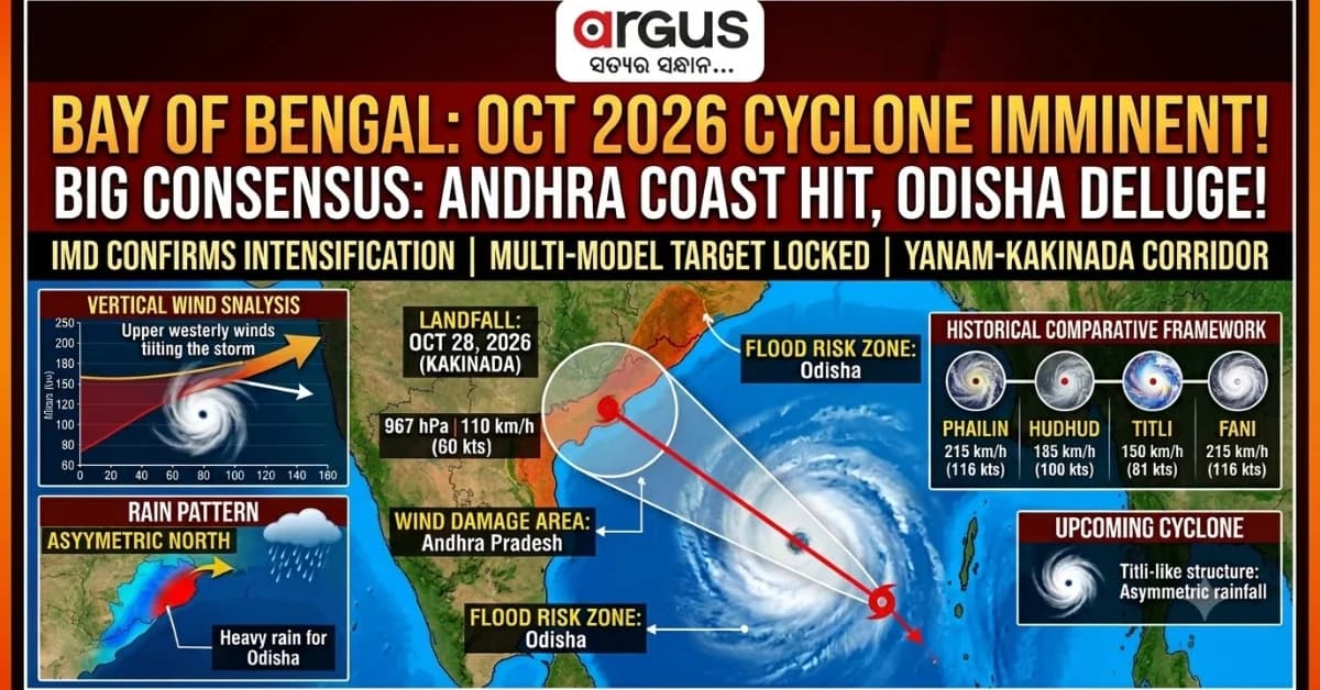
Multi-model consensus points to a direct cyclone landfall over the Yanam-Kakinada corridor (16.7 deg N, 82.5 deg E) on October 28, 2026.
High vertical westerly wind shear will tilt the storm's rain canopy northeastward, bypassing southern AP to trigger severe flooding across Odisha.
Despite moderate surface winds (~110 km/h), an intense central pressure (967 hPa) acts as a powerful moisture pump.
Bhubaneswar: This Morning the upper air cyclonic circulation has moved over to the hot plate of the Bay of Bengal. Within next 12 hours, it will show up as low pressure area in the lower atmosphere. The system will lie in a region with low vertical wind shear, its intensification seems imminent. IMD has also confirmed that the LPA will intensify.
In the context of high-paced
atmospheric transitions over the warm waters of the tropical Indian Ocean, satellite
imagery and upper-air soundings confirm the system shifting rapidly
west-northwestward. (see the image below)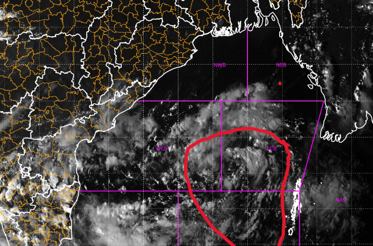 As IMD has stated that intensification
of the system looks imminent, then the process of cyclonegenesis – LPA into a
Depression, Deep Depression, and ultimately into a Severe to Very Severe
Cyclonic Storm – will get unfolded over the bay water from Oct 23 onwards.
As the upper air cyclonic circulation has emerged over the bay water, a rare, high-confidence model consensus has emerged among the world’s premier numerical weather prediction frameworks: the European Centre for Medium-Range Weather Forecasts (ECMWF), the National Centre for Medium-Range Weather Forecasting (NCMRWF) GLB model, the Indian Institute of Tropical Meteorology Bharat Forecast System (IITM CFS), and the Indian National Centre for Ocean Information Services (INCOIS).
While the system is still in its infancy, these advanced physics-based models have converged on a remarkably tight spatial target for landfall.

📱 Get Argus News App
✨The BIG Consensus: The consensus places the eye of the impending cyclone squarely along the Andhra Pradesh coast, targeting the latitude of 16.7°N and longitude of 82.5°E – positioning the absolute centre of landfall directly over the Yanam-Kakinada corridor on October 28, 2026.
INNER MECHANICS OF THE OCT 2026 CYCLONE
To evaluate the true severity of the impending system, we must examine the specific environmental parameters being simulated across the multi-model envelope for October 28:
Hydrodynamic System Profile
Valid: October 28, 2026
- Central Pressure Minimum: 967 hPa (ECMWF)
- Peak Core Wind Velocity: >30 m/s, 52--60 kts)
- Landfall Coordinate Target: 16.7 deg N, 82.5 deg E
- Thermal Fuel Baseline: 29.5 deg C--30.5 deg C SST
1. Central Pressure and Wind Field Discrepancies
The ECMWF deterministic run indicates an intensely deep low-pressure core, with the minimum central pressure dipping to a potent 967 hPa as it nears the coast. Concurrently, INCOIS hydrodynamic models project peak core surface winds exceeding 30 m/s (approx. 60 knots / 110 km/h). Interestingly, the ECMWF surface wind field shows a slightly more conservative 52 knots (~96 km/h).
This structural mismatch – a very deep central pressure paired with slightly suppressed surface winds – reveals a critical diagnostic: the storm will feature an incredibly intense pressure gradient at its core, but its outer wind field is encountering atmospheric friction and vertical wind shear. This indicates a highly compact, dangerous core surrounded by a sprawling, asymmetric envelope of weather.
2. Upper-Level Steering (The 200 hPa Subtropical Ridge)
The NCMRWF GLB and ECMWF 200 hPa streamline analyses show a large, powerful Subtropical Ridge (STR) anchored over northern India and the Tibetan Plateau. The cyclone is trapped along the western and southwestern periphery of this ridge. The clockwise flow around the STR provides a steady northwestward steering current. However, because the system is tracking along the inner flank of the ridge, its translation speed will slow down dramatically as it nears land, prolonging its destructive impacts over the coastal zone.
3. The Mid-level Steering Void
In the mid-troposphere, the environmental steering currents over central India are incredibly weak and disorganized. Without a strong mid-level driver to pull or push the storm, the cyclone's movement is almost entirely controlled by the deep-layer flow between the low-level monsoon winds (850 hPa) and the upper-level ridge (200 hPa). This lack of mid-level control makes the storm highly susceptible to structural tilting.
4. The Vertical Wind Shear Knife
The defining feature of this cyclone is the intense vertical wind shear profile. While the core of the storm sits in a low-shear pocket (~10 knots) over the central Bay, allowing it to intensify, it faces a harsh wall of westerly wind shear (>25–30 knots) closer to the Indian mainland.
As the cyclone climbs northwestward, these high-altitude winds will slice across the top of the storm. Because the storm's mid-level steering is weak, this shear will physically tilt the cyclone's convective towers toward the northeast. This structural tilt will pull the primary rain canopy, freezing levels, and heaviest precipitation entirely away from the physical eye, casting a massive deluge across the entire state of Odisha, while leaving the southern side of the landfall zone comparatively less rainy.
HISTORICAL COMPARATIVE FRAMEWORK (2013–2026)
To understand where this impending 2026 cyclone stands in terms of severity, wind speed, and rainfall distribution, it must be contrasted with the major Bay of Bengal systems that have struck the eastern seaboard over the last decade.
|
Cyclone & Landfall Target |
Key Meteorological Metrics |
|
PHAILIN (2013)
Gopalpur, Odisha |
• Max Wind: 215 km/h (115 kts)
• Min Pressure: 940 hPa
• Rain Pattern: Symmetrical Core Deluge |
|
HUDHUD (2014)
Visakhapatnam, AP |
• Max Wind: 185 km/h (100 kts)
• Min Pressure: 950 hPa • Rain Pattern: Symmetrical Core Deluge |
|
TITLI (2018)
Palasa, AP / Srikakulam |
• Max Wind: 150kmph
• Min Pressure: 970hPa
• Rain Pattern: Asymmetric Northward Rain |
|
FANI (2019)
Puri, Odisha |
• Max Wind: 215 km/h (115 kts)
• Min Pressure: 937 hPa
• Rain Pattern: Extreme Symmetrical Destr. |
|
YAAS (2021)
Dhamra, Odisha |
• Max Wind: 140 km/h (75 kts)
• Min Pressure: 970 hPa • Rain Pattern: North-Heavy Squall Swath |
|
IMPENDING CYCLONE (2026)
Yanam / Kakinada, AP
(16.7 Deg N, 82.5E) |
• Max Wind: 110 km/h (60 kts)
• Min Pressure: 967 hPa
• Rain Pattern: Extreme Asymmetric North
(Odisha Out-Rains AP) |
Cyclone Phailin (October 2013) vs. October 2026
Phailin was an absolute monster that reached Category 5 equivalent intensity over the Bay of Bengal, making landfall near Gopalpur, Odisha with winds of 215 km/h and an ultra-deep central pressure of 940 hPa. Phailin operated in an environment with near-zero vertical wind shear, allowing it to maintain a perfectly symmetrical, terrifying ring of destructive winds and rain right around its eye.
In contrast, the October 2026 system features a much weaker wind field (110 km/h) due to the disruptive westerlies aloft. However, its central pressure (967 hPa) is nearly as deep as Phailin's was near landfall, meaning the 2026 storm will act as an incredibly efficient moisture pump, drawing massive amounts of water vapor off the ocean even if its winds cannot match Phailin's brute force.
Cyclone Hudhud (October 2014) vs. October 2026
Hudhud struck Visakhapatnam as a Very Severe Cyclonic Storm with winds of 185 km/h, devastating the urban infrastructure of northern Andhra Pradesh. Hudhud was steered by a robust mid-latitude trough that pulled it cleanly into the coast.
The 2026 system is making landfall further south (Kakinada, 16.7°N) compared to Hudhud (17.7°N). Crucially, while Hudhud dumped its heaviest rain right along its track into interior AP and Telangana, the 2026 storm’s severe structural tilt ensures its rainfall will bypass southern AP entirely, shifting the flood disaster north into Odisha.
Cyclone Titli (October 2018): The Closest Structural Twin
Cyclone Titli provides the closest historical match for what the 2026 system is preparing to do. Titli made landfall near Palasa, Andhra Pradesh, but surprised forecasters by shifting its entire rainfall payload into the coastal and interior districts of Odisha, triggering catastrophic landslides in the Gajapati district.
Like Titli, the 2026 cyclone is colliding with a strong upper-level westerly shear wall. This will mimic the exact Titli anomaly: the wind damage will be felt at the landfall point in AP, but the actual flood crisis will unfold across Odisha due to the displaced moisture bands.
Cyclone Fani (May 2019) vs. October 2026
Fani was a rare, extremely severe spring cyclone that struck Puri, Odisha with winds of 215 km/h and a pressure of 937 hPa. Fani was a highly organized, tightly wound vortex that brought catastrophic wind destruction to Bhubaneswar and Cuttack.
The October 2026 cyclone will not bring Fani-level winds to Odisha. Instead of a wind disaster, the 2026 system poses a severe water disaster. Fani moved quickly, while the weak 500 hPa steering currents for the 2026 storm mean its rain bands will stall over Odisha for a prolonged 36-to-48-hour period.
LANDFALL MECHANICS AND THE CONE OF UNCERTAINTY
The consensus among the IITM BFS, INCOIS, ECMWF, and NCMRWF models provides an exceptionally clear picture of the landfall timeline and its geographical margins of error.
|
Cone Sector & Bound |
Coordinates & Spatial Impact Details |
|
Odisha Coast
(Adjacent North Sector) |
• Impact: Heavy Moisture Plume / Sheared Rain Canopy
• Mechanism: Upper-level westerly shear pushes cloud mass northward |
|
Northern Boundary
Visakhapatnam |
• Latitude: 17.7 degN
• Role: Upper margin of 5-day landfall probability cone |
|
Consensus Target Eye
Kakinada |
• Latitude: 16.7 deg N
• Role: Primary Track Center Line (Highest probability landfall target) |
|
Southern Boundary
Machilipatnam |
• Latitude: 16.2 deg N
• Role: Lower margin of 5-day landfall probability cone |
|
Andhra Pradesh
(Core Landfall State) |
• Impact: Direct wind core, storm surge, and localized intense squalls |
· The Consensus Target Box: The absolute center of the multi-model track lies at 16.7°N and 82.5°E, pointing to a direct hit on the Yanam-Kakinada coast during the morning hours of October 28, 2026.
· The Northern Bound (Rightward Deviation): If the 200 hPa Subtropical Ridge strengthens over the next 48 hours, it will push the storm along a sharper northward curve. This would shift the landfall point north toward Visakhapatnam (17.7°N).
· The Southern Bound (Leftward Deviation): Conversely, if the system develops as a shallower vortex trapped in the lower atmospheric layers, it will slide further west before turning north, bringing the landfall down toward Machilipatnam (16.2°N).
The Bottomline
The upcoming low pressure area
forming on October 23 represents a complex, asymmetric hazard. Disaster
management agencies must decouple their logistics from traditional track maps.
The multi-model consensus proves that a cyclone's eye is only a small part of
its story. While Andhra Pradesh prepares for the physical landfall and wind
impacts, Odisha must immediately prepare for a major flood-control challenge.
The atmospheric data shows that while the storm may strike the south, its water
is heading straight for the north.
Also Read: EXCLUSIVE|ISRO’s Cyclone Prediction Turning True? IMD Oct 21 Forecast Lends Credibility to NCMRWF, ECMWF ESCS Projections; INCOIS Disagrees
Related Topics
Explore more stories