



Cyclone Akvan / Cyclone likely to cross Andhra coast between Nellore and Tuni on November 20 as very severe storm: IMD
·55 mins ago·3 min read
Key Points
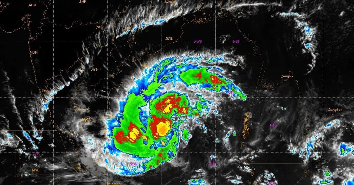
The track and expected landfall location of the developing cyclone over the Bay of Bengal have become clearer, with the system likely to cross the Andhra Pradesh coast between Nellore and Tuni around midday on November 20 as a very severe cyclonic storm, bringing sustained wind speeds of 120-130 kmph with gusts reaching up to 145 kmph at the time of landfall, per the IMD.
Bhubaneswar, Nov 16: The track and expected landfall location of the developing cyclone over the Bay of Bengal have become clearer, with the system likely to cross the Andhra Pradesh coast between Nellore and Tuni around midday on November 20 as a very severe cyclonic storm, the India Meteorological Department (IMD) forecast on Monday.
According to the weather agency, the system is expected to bring sustained wind speeds of 120-130 kmph, with gusts reaching up to 145 kmph at the time of landfall.
The system was moving north-northwestwards at a speed of around 6 kmph and was centred over the southeast and adjoining southwest Bay of Bengal at 8:30 am on Monday, the IMD informed.
It was located around 910 km south of Gopalpur in Odisha and 800 km from Visakhapatnam in Andhra Pradesh.
According to the weather agency, the system is expected to bring sustained wind speeds of 120-130 kmph, with gusts reaching up to 145 kmph at the time of landfall.
The system was moving north-northwestwards at a speed of around 6 kmph and was centred over the southeast and adjoining southwest Bay of Bengal at 8:30 am on Monday, the IMD informed.
It was located around 910 km south of Gopalpur in Odisha and 800 km from Visakhapatnam in Andhra Pradesh.

📱 Get Argus News App
✨📰 60 Word News🎬 Argus Podcast📺 Live TV and Breaking News🔔 Free Notification Alerts
Download Free:
The cyclone is also expected to cross the Andhra Pradesh and Yanam coasts on November 20, according to the forecast details provided.
With the system expected to intensify further before making landfall, coastal districts of Andhra Pradesh are likely to face strong winds and adverse weather conditions.
Odisha braces for heavy rainfall
The developing system is likely to influence weather conditions in Odisha from November 18, with rainfall and strong winds expected in several districts, particularly in the southern parts of the state.
On November 18, light to moderate rainfall is likely at some places in coastal and adjoining districts. The IMD has forecast heavy rainfall at one or two places in Puri, Ganjam and Gajapati districts.
Thunderstorms accompanied by lightning and gusty winds reaching 40-50 kmph are also likely at isolated places.
With the system expected to intensify further before making landfall, coastal districts of Andhra Pradesh are likely to face strong winds and adverse weather conditions.
Odisha braces for heavy rainfall
The developing system is likely to influence weather conditions in Odisha from November 18, with rainfall and strong winds expected in several districts, particularly in the southern parts of the state.
On November 18, light to moderate rainfall is likely at some places in coastal and adjoining districts. The IMD has forecast heavy rainfall at one or two places in Puri, Ganjam and Gajapati districts.
Thunderstorms accompanied by lightning and gusty winds reaching 40-50 kmph are also likely at isolated places.
For November 19, the weather department has issued an orange warning for Puri, Ganjam and Gajapati districts, forecasting heavy to very heavy rainfall at one or two places.
A yellow warning for heavy rainfall has also been issued for Khordha, Nayagada, Jagatsinghapur, Kataka, Jajpur, Kendrapada, Kandhamal, Rayagada, Koraput, Malkangiri, Mayurbhanj, Kendujhar, Baleshwar and Bhadrak districts.
On November 20, rainfall is likely in most places across the state. An orange warning has been issued for Ganjam, Gajapati, Rayagada, Koraput and Malkangiri districts, where heavy to very heavy rainfall is expected at isolated places.
A yellow warning has been issued for Khordha, Nayagada, Jagatsinghpur, Kataka, Jajpur, Kendrapada, Kandhamal, Kalahandi, Nabarangapur, Mayurbhanj, Kendujhar, Baleshwar, Bhadrak and Puri districts for heavy rainfall.
Also Read: Deep depression over Bay of Bengal likely to intensify into cyclonic storm this evening
Fishermen advised against venturing into sea
In view of the developing weather system, fishermen have been advised not to venture into the sea along the south Odisha coast and adjoining sea areas from November 18 to November 21.
Those already out at sea have been advised to return to the coast at the earliest.
A yellow warning for heavy rainfall has also been issued for Khordha, Nayagada, Jagatsinghapur, Kataka, Jajpur, Kendrapada, Kandhamal, Rayagada, Koraput, Malkangiri, Mayurbhanj, Kendujhar, Baleshwar and Bhadrak districts.
On November 20, rainfall is likely in most places across the state. An orange warning has been issued for Ganjam, Gajapati, Rayagada, Koraput and Malkangiri districts, where heavy to very heavy rainfall is expected at isolated places.
A yellow warning has been issued for Khordha, Nayagada, Jagatsinghpur, Kataka, Jajpur, Kendrapada, Kandhamal, Kalahandi, Nabarangapur, Mayurbhanj, Kendujhar, Baleshwar, Bhadrak and Puri districts for heavy rainfall.
Also Read: Deep depression over Bay of Bengal likely to intensify into cyclonic storm this evening
Fishermen advised against venturing into sea
In view of the developing weather system, fishermen have been advised not to venture into the sea along the south Odisha coast and adjoining sea areas from November 18 to November 21.
Those already out at sea have been advised to return to the coast at the earliest.
Related Topics
Explore more stories