He also met several world leaders, including Chinese President Xi Jinping, Russian President Vladimir Putin and UAE President Sheikh Mohamed bin Zayed Al Nahyan on the sidelines of the BRICS Summit on Wednesday.
"PM @narendramodi wraps up an impactful visit to Kazan and emplanes for New Delhi," the Ministry of External Affairs (MEA) posted on Wednesday on X.
He described the BRICS Summit in Russia's Kazan as "very productive".
He thanked Russian President Vladimir Putin, the people of Russia and their government for their hospitality.
PM Modi took to X to share glimpses of his visit to Russia. During his visit to Russia, PM Modi addressed two sessions of the BRICS Summit held in Kazan under Russia's chairmanship.
While sharing the video on X, PM Modi said, "The BRICS Summit in Kazan was very productive. Had the opportunity to discuss diverse issues and meet various world leaders. I thank President Putin, the Russian people and the government for their hospitality. Here are the highlights."
PM Modi said, "In its new form, BRICS is an economy bigger than $30 trillion. BRICS Business Council and BRICS Women Business Alliance have played a special role in increasing our economic cooperation. The consensus reached within BRICS this year on WTO reforms, trade facilitation in agriculture, resilience supply chains, e-commerce and special economic zones will strengthen our economic cooperation. Among all these initiatives, we should also focus on the interests of small and medium-scale industries. I am happy that the BRICS Startup Forum proposed during India's chairmanship in 2021 will be launched this year. The Railway Research Network initiative given by India is also playing an important role in increasing logistics and supply chain connectivity between BRICS countries."
In the video shared by PM Modi on X, he could be seen participating in the BRICS Summit in Kazan.
The video showed PM Modi meeting several world leaders, including UAE President Sheikh Mohamed bin Zayed Al Nahyan and Uzbekistan President Shavkat Mirziyoyev.
On Wednesday, PM Modi also met Egyptian President Abdel Fattah El-Sisi in Kazan. In a post on X, PM Modi said, "Happy to have interacted with President Abdel Fattah El-Sisi in Kazan."
He also held a meeting with Uzbekistan President Shavkat Mirziyoyev in Kazan and discussed ways to boost bilateral cooperation between the two nations.
"Had a wonderful meeting with President Shavkat Mirziyoyev in Kazan. Discussed ways to boost bilateral cooperation between India and Uzbekistan, including trade and cultural linkages," PM Modi posted on X.
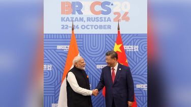
PM Modi met Chinese President Xi Jinping in the Russian city of Kazan on the sidelines of the BRICS Summit.
The meeting marks the first formal structured interaction between the two leaders in five years. The meeting comes after the two countries reached an agreement on resuming regular patrolling along the Line of Actual Control (LAC) in eastern Ladakh.
After meeting with Chinese President Jinping on the sidelines, PM Modi said, "India-China relations are important for the people of our countries and for regional and global peace and stability."
Sharing details about his meeting with the UAE President, PM Modi wrote, "Glad to have met my brother, Sheikh Mohamed bin Zayed Al Nahyan, President of the UAE, on the sidelines of the BRICS Summit in Kazan."
In his address at the BRICS Summit, PM Modi noted that the Summit is happening at a time when the world is undergoing several uncertainties and challenges, including conflicts, adverse climatic impacts, and cyber threats, placing greater expectations upon BRICS.
He suggested that the group take a people-centric approach to tackle these challenges.
PM Modi also underlined the need for early adoption of a Comprehensive Convention on International Terrorism at the United Nations to combat the menace of terrorism.
He called upon BRICS to proactively push for global governance reforms.
Recalling the Voice of Global South Summits hosted by India during its G20 Presidency, he stressed that the group must give primacy to the concerns of the Global South.
PM Modi noted that the regional presence of the New Development Bank including in GIFT city, India, has created new values and impacts.
Highlighting BRICS' activities to foster economic growth, he emphasised that its efforts on trade facilitation in agriculture, resilient supply chains, e-commerce and Special Economic Zones have generated new opportunities.
He underlined the need to prioritise small and medium-scale industries.
He expressed that the BRICS Startup Forum, initiated by India which is to be launched this year, would add significant value to the BRICS economic agenda.
The Prime Minister elaborated on the recent green initiatives undertaken by India, including the International Solar Alliance, Coalition for Disaster Resilient Infrastructure, Mission LIFE and Green Credit initiative announced during COP28. He invited BRICS countries to join these initiatives.
On Tuesday, PM Modi held a meeting with Russian President Vladimir Putin on the sidelines of the BRICS Summit in Kazan. PM Modi invited Putin to visit India next year for the 23rd India-Russia Annual Summit.
The two leaders reviewed bilateral cooperation in various sectors, including political, economic, defence, energy, and people-to-people ties, the Prime Minister's Office said in a press statement.
In a post on X, PM Modi said, "Had an excellent meeting with President Putin. The bond between India and Russia is deep-rooted. Our talks focussed on how to add even more vigour to our bilateral partnership across diverse sectors."
This was their second meeting this year as the two leaders had earlier met in Moscow for the 22nd India-Russia Annual Summit in July 2024.
PM Modi also held a meeting with Iranian President Masoud Pezeshkian and discussed ways to deepen bilateral ties in futuristic sectors.
"Had a very good meeting with the President of Iran, Masoud Pezeshkian. We reviewed the full range of relations between our countries. We also discussed ways to deepen ties in futuristic sectors," PM Modi posted on X.
This visit marked PM Modi's second visit to Russia this year as he visited Moscow in July for the annual India-Russia Summit.
(IANS)
Read more National News