



Vikshit Odisha / NIT Rourkela Patents India’s First Real-Time Land Mapping Drone ‘BHU-MANACHITRA’
Key Points
Lightweight AI model enables onboard processing, eliminating need for external systems.
Applications span agriculture, disaster management, urban planning, and environment monitoring.
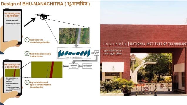
Rourkela, Nov 20: In a groundbreaking achievement, researchers at the National Institute of Technology (NIT) Rourkela have secured a patent for BHU-MANACHITRA—India’s first autonomous drone system capable of real-time land mapping. The innovation combines Artificial Intelligence (AI) with Unmanned Aerial Vehicle (UAV) technology to deliver instant, accurate maps without internet connectivity, external computers, or manual intervention.
A Leap Beyond Conventional Models
Unlike traditional drones that capture images for later processing, BHU-MANACHITRA performs all computations onboard. This allows the drone to recognise land features such as farmlands, forests, vegetation, and urban areas in real time. The system addresses a major limitation of existing deep-learning models, which often struggle to interpret crowded aerial images and produce unstable maps.

📱 Get Argus News App
✨
The Research Team
The patented system (Patent No. 573507) was developed under
the leadership of Prof. Sambit Bakshi, Associate Professor, Department of
Computer Science & Engineering, along with Dr. Tanmay Kumar Behera, Dr.
Debbrota Paul Chowdhury, and Ms. Camellia Ray. The project was jointly
supported by NIT Rourkela and IIT Patna Vishlesan I-Hub Foundation (TIH IIT
Patna), funded through the National Mission on Interdisciplinary Cyber Physical
System (NM-ICPS) of the Department of Science and Technology (DST), Government of
India.
Also Read: NIT Rourkela Advances to 652nd in QS Sustainability Rankings 2026
Applications Across Sectors
The system’s versatility makes it a valuable tool across multiple domains:
• Government agencies can modernise land records, support urban planning, and advance smart city projects.
• Agriculture departments can assess crop conditions, soil health, and irrigation needs instantly.
• Disaster management authorities can access immediate terrain data during floods, landslides, or earthquakes.
• Environmental agencies can monitor deforestation, encroachments, and biodiversity changes effectively.
Lightweight AI for Real-Time Processing
Prof. Bakshi highlighted that the methodology uses a lightweight AI model with only 2.48 million parameters, making it suitable for drones that cannot carry heavy hardware. This ensures long flight times while enabling onboard processing, a critical advantage in remote or disaster-hit areas.
Towards Smarter Governance
The innovation aligns with national initiatives such as Digital India and Atmanirbhar Bharat. By enabling faster decision-making, efficient resource management, and stronger disaster resilience, BHU-MANACHITRA represents a significant step toward smarter governance and sustainable development in India.
Related Topics
Explore more stories